A few guests thought today that I could predict the future as yesterday I explained to them when they could expect the ship to quiet down. I was right within about 30 minutes and that was considered amazing. It was of course not amazing at all, you just need a ruler. You lay that ruler on the chart in the general direction on the swell and move it towards the south side of Cuba. When the ships track comes north (or above) the line of the ruler after the ruler has hit the coast, then you have the probable moment when the swell will disappear. The swell is mostly a bit diffuse as well so you cannot pin it down to the minute but within the hour is possible. Nothing complicated but I will take the credit gladly.
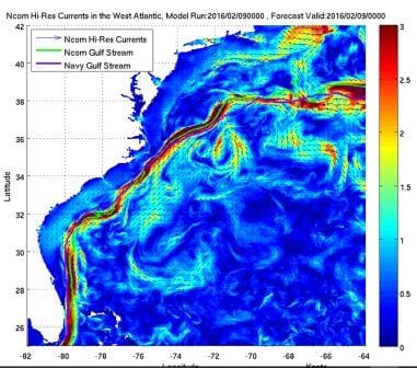
This is an example of a compressed Gulf Stream Chart from the NOAA. The deeper the red the stronger the current.
Early this morning we passed the west point of Cuba and then turned into the Straits of Florida and the Gulf Stream. To attain maximum advantage the navigator will first plot a course which is the shortest between Cabo San Antonio (Cuba’s West point) and the Miami area. That is where the Florida Coast & keys really curve, so the ship has to bend with the coast line. Then the course is adapted to where we think the axis of the Gulf Stream is so we can catch an extra push in the back of anything between 1 to 4 knots. The NOAA makes charts available on the internet with the average axis of the Gulf Stream but these charts are past observations and the Gulf Stream can move very quickly. Sometimes closer to Florida, sometimes closer to Cuba.
Thus we tend to aim and for the average axial line until we get there with the ship. Then we observe of how much more speed we are getting, compared to what we normally get from the engines. And then we try to get the best by steering a bit more one way or the other. If you have to maintain 18 knots and if you can find 4 knots free of charge then a bit of experimenting is worthwhile. Under water the Straits of Florida are in deep part quite a bit smaller then what it looks like on the surface. Water gets squeezed in a bit. So the closer we come to the South point of Florida, the more pronounced the current becomes. Especially if we are in the right location.
The Gulf Stream goes North East and later North following the curve of Florida and the Bahamas. But as water will flow back where it has been pushed away, there are also counter currents. Smaller, but still of interest. One runs along the Florida Keys to the South West, the other one north of the Cuban coast. The Florida Key one is the strongest as it can flow freely into the Gulf of Mexico. The one north of Cuba is less pronounced as it has to push (or try to push) its water around Cabo San Antonio. Still if you have to go that way then you might as well use it. Thus it made sense this morning when we saw a Celebrity Cruise Ship going towards the Caribbean sailing as close as possible to the Cuban coast. Taking advantage of this counter current or at least avoiding going against the edges of the Gulf Stream Looking at its speed it looked like she was nicely picking up a knot of so of this counter current.
This morning the good ship Zuiderdam had the benefit of 1.5 knots and by the evening it had increased to almost 3 knots. the 1.5 knots did not add much to the ships speed but it counteracted nicely to the strong East North Easterly wind that is blowing. For most of the day we had about 45 knots of it in relative speed. Take off 16 knots of the ship’s speed and that leaves around 30 knots of true – opposing – wind. Good enough to slow you down by a knot or so. Thus the Gulf Stream is nicely compensating. This wind is caused by a strong Weather front similar to the one which made us cancel Puerto Limon.
Tomorrow we are back in our home port Ft. Lauderdale but it is scheduled to be a quiet day as far as cruise ships are concerned. First ship in at 04.00 hrs will the small coastal passenger ship Pearl Mist followed by the Costa Deliziosa and the Coral Princess. The ms Zuiderdam will be the last in the line up, coming in at 06.15 to be docked at 06.50 at Pier 26. Ready for another turn over day at 07.00 hrs.
Weather for tomorrow: The wind is supposed to die down to about 12 knots and we are expecting partly sunny skies with temperatures just short of 80oF or 26oC.

March 8, 2017 at 6:09 pm
A fascinating exposition on the effects of currents and wind based on your many years of experience as a Navigator/Captain. I have read this before, but I always love reading it again. Assuming a ship the size of the Zuiderdam, how much difference in fuel costs will a 3 knot following current have (per hour, or per day) assuming you have to make good 18 knots to your destination ?. Thank you as always Capt Albert.
March 8, 2017 at 8:15 pm
Good morning,
the easiest thing to say would be the same percentage of wind towards the speed of the ship. Thus 17%. But it is does not work that way, as the propellors keep turning and the hotel consumption continues. The way it then works is that we can quicker stop an engine and still make it at the same time to the next port as scheduled. So instead of running on 3 engines, we can go down to two engines as soon as we reach the average speed needed which two engines can deliver. I had in the past several discussions with the Ch. Engineer and we tried to calculate it as best as possible, and as a rule of thumb we came to half of the ratio. So if 3 knots against 18 knots is 17% then the fuel saving for the mileage distance we had that happy current is about 8 to 9%. ………… and that still makes a Chief engineer very happy.
Best regards
Capt. Albert