- Captain Albert's Website and Blog -

Ocean Liner History and Stories from the Sea, Past and Present. With an In Depth focus on Holland America Line

Page 77 of 241

01 August 2016; At Sea.

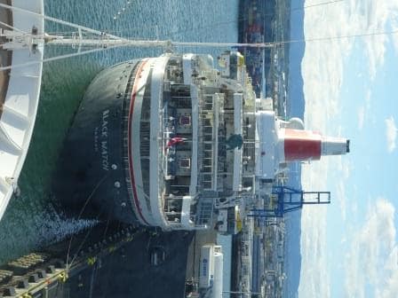
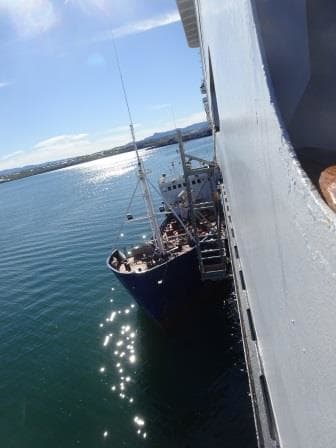
After we left Reykjavik last evening, we sailed around the south side of Iceland. Which is the shortest route to go east while rounding the Island. For our Casino players it caused a bit of inconvenience as the Casino remained closed until close to 10 pm. Reason, the ms Rotterdam remained within the 12 miles zone for about 5 hours.  And nothing the Captain could really do about unless he made a very big detour and then the cost of fuel would never make up for any winnings there might have been. (And as it is a Casino you are never certain that the House would have won that evening)

Thus while the Casino addicts where having withdrawal symptoms the ship curved around the south side of Iceland until it finally got outside the 12 mile zone. Why the 12 miles zone? Most European countries maintain a no gambling rule inside the 12 mile zone. Regardless of whether the ship will call at a port in that country or not. For North and Middle American ports it is normally 3 miles and sometimes you can already open once the ship has let go all the mooring lines.  I have even been in the situation that we were allowed to have the Casino open in port as long as nobody from the outside could get on the ship. So the purser has to carefully check for each destination what the rules are to ensure the ship does not break a rule as the penalties can be severe.

to make things complicated

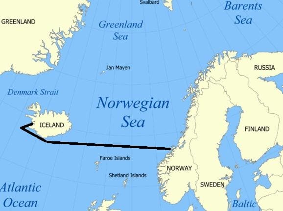
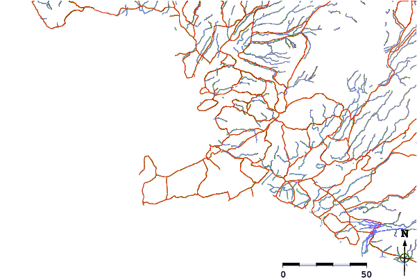
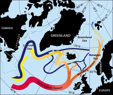
Our route  to Alesund. To make things complicated mankind has decided that the stretch of water between the North Atlantic Ocean and the Arctic Ocean is called the Irminger Sea, the Denmark Strait, The Norwegian Sea, The Greenland Sea and the Barents Sea. And it is all the same salt water.

When we plan a cruise we try the stay outside the 12 mile zone as much as possible. And quite often we can do so, if we just tinker a little bit with making the shortest course line just a tiny little bit longer, but it does not always work that way. And thus the decision is sometimes, the Casino has to stay closed for a few hours until the ship comes outside the magical 12 mile zone.

The shops on board have often less stringent rules. Most of the time they cannot be opened in port with the exemption – sometimes – of the shop which acts as a Drug Store and which does not sell any duty free goods. Then there are situations where a local tax has to be levied onto any sale a shop on board makes if it is within a certain zone. Florida has such a ruling. Within the 3 mile zone from the land, local tax has to be added to any transaction. Whether it is shop purchases or drinks from the Bar. For the shops the situation is we simply keep them closed until we are out of the 3 mile limit. That is most of the time already very shortly after departure and by opening the shops at 18.00 hrs. with a 17.00 hrs. departure we solve all the complications.

Today we do not have that problem. Once we cleared the 12 mile zone we were in normal international waters again and we will remain so until we come to the Aalesund pilot station. During the night we will pass north of Faroe but we will stay well clear of those islands. No extra income for them.

A Map view looking down upon the Northpole with Iceland to the South. The darker the blue color, the deeper the water.

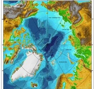
A Map view looking down upon the North pole with Iceland to the South. The darker the blue color, the deeper the water.

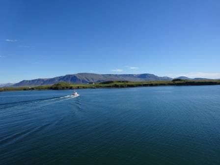
The area we are crossing is part of the North Atlantic Ocean but is called here the Norwegian Sea.  To the North it is bordered by the Arctic Ocean and then to the south by the North Atlantic Ocean proper.   A chance of running aground we do not have here either as the water depth is well over 5000 ft. One of the reasons we do not see any oil rigs here,but something we will extensively see when coming down from Aalesund.   This area has always been water and was never dry land and thus no tropical forest which then through time turned into Fossilized Fuel. From Iceland the depth takes quite a plunge and only rises steeply up when coming close to the Norwegian continental shelf.

Today the weather was typical for this area. Due to the influence of the warmer water from the South which mixes with the colder water from the north, you can get quite unstable weather here resulting in summer storms. There was one here a few days ago and thus we have a slightly moving ship reminding us we are not on a coach trip. Mostly overcast skies although in the late afternoon it started to clear. Temperatures did not come much higher than 9oC/ or 45oF due to the cold wind from the North. Not good weather to sit outside for very long. But for that purpose Trivia Pursuit and Bingo was invented on the ships.

Tomorrow is our 2nd day at sea and to get in synch with the Central European Time we will go one more hour forward tonight and then it is done with moving the clock for the remainder of the cruise.

31 July 2016; Reykjavik, Iceland 2nd day.

 Today was our 2nd day in Reykjavik and we were joined by another cruise ship. The Black Watch from Fred Olsen Lines which is about half the size of the Rotterdam.  It is an older ship and it started its life in the early days of cruising as the Royal Viking Star. She was one of three ships built between 1971 and 1973 for the Royal Viking Line and offered in those days the top level of cruising. This was in the early days when new cruise companies were founded. Royal Viking eventually folded and via a few other owners she ended up with Fred Olsen in 1996.

Our neighbour for today. In the centre of the Lido is a scuplture which is a trademark of Fred Olsen. These are "recycled" Bow figure heads of the old ferries of the the Fred Olsen Lines.

Our neighbour for today. In the centre above the Lido is a green bronze sculpture which is a trademark of Fred Olsen. These are “recycled” Bow figure heads of the old ferries of the the Fred Olsen Lines. Those not in use stand in the garden of the owner in Norway.

Fred Olsen is a 3 star company which mainly sails for the British market and specializes in the older clientele.  I was a little bit surprised to see her here as she was not on the cruise call list we had. Not that is unusual as often the schedules are based on the port bookings made two years in advance and later additions are not always added.  Holland America normally makes their reservations about 18 months in advance, as soon as the go ahead is given to print the brochures. Then a cruise is really set in stone and the cruise schedule has to be backing up the cruise planned. At least for as far as nothing changes in the period until the cruise starts. If we look what is going on in the world at the moment, we know that changes are constantly happening.

The weather turned out better than expected and the rain/showers are now being predicted for the tomorrow. It looks like the weather system expected has slowed down a little bit and that is good for us.

Part of my day today was spent  on training. I finished my ships inspection on behalf of the captain and the various departments are now following up whatever I found. Which was not much in perspective if you take into consideration how many lockers, compartments, nooks and cranny’s a ship has. So when I do such an inspection, then you look at everything you see, from the point of view: is it safe and is it in compliance with the company’s rules and regulations.   As I mentioned before, it is more about providing a fresh view from the outside than there is need, because the ship is having problems. Holland America Line operates on a very high level (even if I say so myself) and what we find during inspection is the really small stuff.  But then, if you catch a small item, it will not grow to it a big problem.

So my small problem catching phase is now over and we move on to the training bit. Every Cruise guest knows about the big drills. They are part of it themselves before we leave port.  Then during the cruise, sometime between 0900 hrs. and 12.00 hrs., there will be bells and whistles and announcements as the Captain and his team are creating / simulating mayhem somewhere. On occasion you might walk right into that mayhem if the emergency is simulated in the area where you happened to be. However those are the big drills where everything comes together. Underlying it is the small – on the job—trainings which prevent at least 90% of what could result in all those bells going off in reality.

We can this First Response Training. And every group on board who works in an –even marginally – challenging location will take part in these monthly trainings. Biggest focus groups are those who have to evacuate lounges such as dining room personnel or those who could create the danger themselves, such as the Galley Staff.  Thus every month we refresh the crew on location about what the routines are, what they have available to control an emergency (we talking fires normally) how to get backup from the Bridge and what to do if the issue is too big to handle by themselves.

Why are these refreshers needed? For several reasons; most of the crew is over 25 and thus we forget, so when we come back from vacation we have forgotten everything anyway (Ask any manager in any ship or in any hotel) and as we rotate from ship to ship where the layout might have been different and often the important buttons are in a different location than what a crewmember is used to. These trainings do not take long, 30 minutes on average and then everybody is back up to par again.

Tomorrow we are at sea and making the 860 mile crossing over part of the North Atlantic Ocean between Iceland and Norway.  It will take us two days to get to Scandinavia of which Norway forms the West side. We will also have two hours forward, which will put us tomorrow on British Time and then the day after on Norwegian or European time.

30 July 2016; Reykjavik, Iceland.

With a bright & sunny sky we approached the pilot station and the pilot hopped on board as scheduled at 07.00 hrs. Then it was only a short distance into the port and by 08.00 the gangway was in. We are using here a shore gangway as it is longer than our own and thus easier for when the tide goes up and down. The longer the gangway, the less steep the incline is when the ship goes up on the tide. The local authorities are prepared for this as the tide here can vary about 15 feet. Today it is not so extreme; the maximum difference is going to be about 9 feet. With the high tide being at 15.30 and the low tide happening about 6 hrs. later. In our case tonight at 10 pm.  That is a little bit more than 6 hours but then local tides always differ from the exact six hour rule due to the layout of the land and the inlets etc.

Looking at the coast around Reykjavik (just above the long finger sticking out) you need quite a few stations to get a good prediction.

Looking at the coast around Reykjavik (just above the long finger sticking out) you need quite a few stations to get a good prediction. The blue stripes are little river and nearly every little river has such a station nearby.

To get this information as accurate as possible, most countries have tidal stations along the coast which measure constantly the exact local tide highs and lows and eventually this results in tidal predictions which are very near what happens on the day for which the prediction is given. It is never a 100% as a bit of wind, or a slight change in current can put the real result a few minutes off, or create half an inch in height difference. That is something we can live with.

Commercial harbor. (Thank you Google Earth)

Commercial harbor. (Thank you Google Earth) The dotted line is the little ferry to Videy)

We are docking today at a dock which has the very Icelandic name of Skaribakki and the port area is called Sundahofn.  This is the outer harbor. If you are on a very small cruise ship you can dock in the old fishing port in downtown. But anything over 15,000 tons is already quickly moved to the commercial port. Makes sense as there is more room here for the buses, for supplies, for gate security and for the obiqious souvenir shop.  (Which is conveniently situated next to Security, so when you come back, you come back through the shop) But the hop on hop off bus stops outside the gate and thus we all should be able to live with it.

Little ferry to Videy. Maybe because of the nice weather but it was full all day.

Little ferry to Videy. Maybe because of the nice weather but it was full all day.

As it is Saturday there is not much going on and thus the port is quiet. The only thing we see on a regular basis is the small ferry boat which goes to the island of Viioey (Also spelled Videy). This island forms the Northside of the natural harbor entrance for Reykjavik. From the ship the island looks just like a grass covered hill with a large house at the west side and a large house at the eastside. But there is more to it than the eye sees. Yoko Ono has a work of art there (Imagine Peace Tower) and the house you see on the photo is the Videy house and this was the first building in the country to have been constructed from stone. I wonder where they got those stones from as Iceland is mainly rock and there is not much clay or sandstone out there.

We bunkered 500 tons of MGO here and it came by a small coaster. With this weather not a bad job to do.

We bunkered 500 tons of MGO here and it came by a small coaster. With this weather not a bad job to do.

As we are here two days, the ship plans accordingly and tries to do most compulsory things on the first day so the 2nd day gives the crew more chance to go ashore. (Unless you are stuck with safety duty of course) Thus we had the bunkering going on and we had the lifeboat and liferaft drills. Today we also have crew change over, witch helps with a  2nd day as well, as it is all much easier if you have a day alongside to settle in.

I do not know what the crew will do in the evening, as transport is very expensive and drinks are even more expensive. But if they do, it will be strange to come out of the Pub or Dancing in the early morning hours and find it is still daylight. At least to a certain extent. We have the mid night summers day here, when the sun does not set and even now in late July (sunrise at 04.28 and sunset at 22.36) it does not really get dark.

So tomorrow we have a 2nd day in port and we will not leave until 17.00 hrs.  Yesterday I remarked that the 2nd day would bring rain but now it has improved to scattered showers with temperatures of 17oc / 57oF.  Thus it should still be a good day to go ashore but I hope everybody went to day as it was a gorgeous day.

29 July 2016; At Sea.

Today we have a day at sea, to get to Iceland and doing so we cross two time zones. So last night we went an hour forward and tonight we will do it again. No doubt the Beverage Manager is not a happy camper as hours forward are not good for the Bar Revenue. (And we get two more between Iceland and Aalesund Norway) This area benefits from the confusion of what it is exactly to be called. The area along the East coast of Greenland is called the Irminger Sea and the area closer to Iceland is called the Denmark Strait. And then the whole larger area is called the North Atlantic Ocean.

The weather has also changed and today it was a dull day with the wind and swell increasing in the afternoon. Whatever the weather here is, it is different to the west side of Greenland. This is mainly caused by the Gulfstream. Although the Gulf Stream predominantly flows at lower latitude across to Europe, and then goes under England along the coast of the lowlands; a smaller branch turns northwards and brings warmer water to the area we are now sailing in. For the time of year this means normally less fog as wind and water do not vary much in temperature. It would need a very cold northerly wind to accomplish something.

A minor branch of the Gulf Stream doubles back to under Iceland.

A minor branch of the Gulf Stream doubles back to under Iceland.

In the winter time the Gulf Stream does have a negative result, and it does that in conjunction with the Jet stream. The Gulf Stream generates about every three days a new storm off Cape Hatteras. It comes up right under the coast there from Florida and then goes across. While the Jet Stream propels these depressions across, their force is being nurtured by the warmth of the Gulf Stream.  Now whether Europe gets a storm or not, depends on where the Gulf Stream is going. If there is a High Pressure ridge over the Azores, the Jetstream tends to bend to the North towards Iceland and then they get the storm.  If this is not the case, then the storm goes straight across and makes a landfall either at Ireland or at the south west area of England.

Most winter storms go the Iceland way. Maybe another reason they do not have much in the ways of trees there. During the winter it blows here quite often (about every three days). If a storm makes it to densely populated Europe then there are fun and games. Especially if the storm arrives in combination with a Spring Tide. Then the water is already high to start with and then an extra push by a strong storm: and along the coastlines of England, Scotland and the Netherlands the alarm bells go off.  In Holland we had a very bad one in 1953 when the (weak) dykes broke through. As a result the Dutch really went to war and now the enormous Dykes and Water Barriers protect the areas where there are no dunes. A lot of tourists now come to see what has been done there and the “Delta Werken” are a standard part of a tourist tour through Holland.

But even in my little English Home town, tucked away in the east corner of England, we had fun and games fairly recently . In 2013 there was a spring tide, the wind was at the right (or wrong angle) and the sea barriers and Beach huts took a severe battering.  And that was away from the full force of this Spring Tide storm. I cannot post any photos of  this as otherwise I run into copyright issues with the English newspapers.

We did not have any bad weather today and the excitement on the bridge was limited to a ship we passed at 10 am. on our portside and which we could not identify. All ships over 300 tons are required to have an AIS on and then it takes one click on the Radar and we know who it is. They did not, naughty boys, and thus the guessing started. First idea was a fish processing plant as the ship was white and sitting just outside the 200 mile zone off the Greenland Coast and thus local fishing rules would not apply. We did not see a net but there was something hanging from the stern. The funnel colors were, yellow, blue grey and those colors I have seen on both USA and Russian companies. So we thought maybe it was a scientific vessel.

The Zeus cable layer for the US navy. I wonder if the US Navy is branaching oout in the TeleCom business.

The Zeus cable layer for the US navy. I wonder if the US Navy is branching out in the TeleCom business.

My guess was the US Sealift Command as that would explain the no AIS signal as military vessels are not required to use an AIS. So I turned to my friend Google and he knew the answer. It was the USNS Zeus (T-ARC-7) a cable laying vessel of the US navy.  As you can see never a dull moment at sea.

Tomorrow morning we should be at the pilot station at 07.00 hrs. and docked about an hour later. We are staying two days as there is too much to see and enjoy in Iceland to cover in one day.

Weather for tomorrow, Sunny with temperatures of 67oF/ 17oC and a bit of a breezy day. For Sunday rain is expected so hopefully nobody will leave it to the 2nd day to go ashore.

28 July 2016; Prince Christians Sund.

As soon as we had left the port yesterday we were enveloped in this white cloud again. But in the early morning it came to an end and we were greeted with a gorgeous view of the coast of Greenland. Clear blue skies and hardly any wind outside and thus no wind inside. Seas flat as a mirror.

Finally a nice big Iceberg for all to see, marking the Western Approaches.

Finally a nice big Iceberg for all to see, marking the Western Approaches.

By 7 am. we approached the Western entrance which was nicely marked by several icebergs which had happily run aground there. Then we sailed in with the gentle speed of about 10 knots which resulted in a schedule of leaving again at the other side around 5 pm.  Our two pilots were in full swing, taking alternative turns in advising the bridge team of what would be the best way of going through. Most of us have been here now several times but pilots are normally crossing this area more often than we do.

Ragged mountains peaks dominate the Western Entrance.

Ragged mountains peaks dominate the Western Entrance. And a sea as flat as a mirror.

On average the water is quite deep but there are a few shallows spots, which are not an issue as long as there is no ice in the deep spots next to it. Then there is one tight and narrow turn where it is easier also not to have an iceberg in the way. Luckily inside the Sund the bergs are normally not that big that it has ever formed a real problem. The real big icebergs are coming down from Upper Greenland area (Disko Bay etc.) and they float down the coast. It has been known to happen that a transit had to be cancelled as a Berg blocked the Western entrance but it is not really common. The Sound or Sund is named after Prince Christian later King of Denmark in the 19th. Century. (I might be a bit off as there one more than one Christian if my memory serves me right and I think was nbr 7 or 8) The Sund has a length of 100 kilometers or about 54 Nautical Miles and that is why we can trundle though at a very sedate speed and even stop at the Glaciers along the way.

View from the Bridge. Two pilots and thus two bottles of water.

View from the Bridge. Two pilots and thus two bottles of water.

The Sund connects the Labrador Sea with the Irminger Sea which is the body of water between Greenland and Iceland. There is one (lonely) village in the middle of the Sund called Aappilattoq, with 132 inhabitants, and it is lonely because all around it the mountains go up to several 1000 feet. They have a helicopter connection with the outside world but for the rest contact is only by sea.  I remember that in the early days a cruise ship once stopped there to land medication, as the village had been cut off for some reason from the outside world for some time.

The Navigation chart of the Sund. As you can see it is not a straight channel but here it almost doubles back on itself.

The Navigation chart of the Sund. As you can see we do not follow the straightest route possible but almost double back on ourself. We follow the deep water & glacier route which results in going around a long island.

As mentioned yesterday, this area is not covered yet by the Electronic charts system and thus the navigators went back to the good old days and verified the ships position by bearings plotted on paper.  The area has some semblance to Alaska with Glacier Bay but the fjord is generally tighter (narrowest point is about 1500 feet wide) and it looks different as the rocks are of a different composition. Here we have mainly white granite which gives the mountains an elephant greyish hue while in Glacier bay it is more black or sometimes red (streaks of iron deposits) It is not a National Park and thus no Park Rangers for the commentary. That is done by our own Travel Guide Barbara who has been here many times and has no problem to explain all that comes floating and flying by.

One of the several Tide water glaciers coming down from the Greenland Ice Cap.

One of the several Tide water glaciers coming down from the Greenland Ice Cap.

The biggest difference between the West side and the East side is the way the mountains are shaped. At the west side they are very ragged and sharp as normal mountains have not been touched by the grinding motion of water or ice. The East side has been and thus the mountains are more rounded and shapely. Greenland is still covered with ice but during the ice ages it must have been very impressive here as even these rounded mountains reach a considerable height.

The mountains on the East side are more rounded courtesy of Glaciers polishing the tops down.

The mountains on the East side are more rounded courtesy of Glaciers polishing the tops down.

This was the best Prince Christian Sund transit I have ever seen and I hope the guests will appreciate it, as it is not always the case. It can rain, there can be no visibility, there can be an un-expected storm, you never know. Or an Iceberg can block the Sund somewhere. Today was really good: 10 points out of 10.

Tomorrow we are at sea, crossing the Irminger Sea on our way to Iceland. There we will stay two days as it takes more than one day to explore this fascinating island.

Weather: We are still close to Greenland so it can be anything. Maybe the captain has to blow the horn again; maybe he will have an un-interrupted nice sleep. We will see.

Close up. Every glacier has a river under it which transports the melt water and also helps it to slide down the mountains. This is a big tunnel / river exit.

Close up. Every glacier has a river under it which transports the melt water and also helps it to slide down the mountains. This is a big tunnel / river exit.

27 July 2016; Qaqortoq, Greenland.

The officers on the bridge are not having an easy time. The nice weather with the relative high temperatures creates prolonged periods of reduced visibility and thus the ships whistle kept going all through the night. Only when entering the bay of Qaqortoq did the curtain suddenly open up and was it clear again. Less cold water enters the bay, the rocks maintaining the warmth overnight and the mountain ridges shelter the area from the cold wind. In the bay it was as clear as a whistle but outside the white wall remained all day long.

This time a shot of the Radar without a chart which shows the area. The red line is the tender route to the dock.

This time a shot of the Radar without a chart which shows the area. The red line is the tender route to the dock.

Greenland has not been much in the picture of the maritime world yet as the area has still not been digitized as far as the sea charts are concerned. We can now sail over most of the globe with the chart on the Radar, so the radar picture overlays the chart (and hopefully merge exactly) but not in Greenland’s waters. To go onto the Radar, the charts have to be digitized and also verified for the correct standard of digitization. Greenland is not there yet and thus for the coming days, we have to pull out the paper charts and do it the old fashioned way with ruler and pencil. But we also had the two local pilots on board who ensured we stayed on the dotted line.

This is as close as we have come to an ice berg thusfar. A poor lonely boy which has ran aground and is now melting away.

This is as close as we have come to an ice berg thus far. A poor lonely boy which has ran aground and is now melting away.

We were supposed to see Ice bergs, but as it was a small white world, we did not. Luckily with the modern radars the larger ones do show up on the Radar and also the pilots have the ice forecasts and they know where the big boys are drifting to. We had no big boys and only saw a few smaller ones which had run aground in the bay and were slowly melting away. The more north you go, the more you see them and on occasion they can block off the complete harbor of a town. Some towns have a tugboat available to pull the Bergs that want to get into the harbor, back to open waters again and then hope for the current to push them away. And maybe to the next town.

The whole village is built against the mountain range so getting anywhere is good exercise.

The whole village is built against the mountain range so getting anywhere is good exercise.

We had a beautiful day here, with the ship being in port from 10 am until 18.00 hrs. As is with most villages and towns in Greenland, Qaqortoq is very isolated. There is an air strip but nearly all traffic along the coast is by means of three ferries which run all the way from Qaqortoq up the coast, via Nuuk the capital, to  IIulissat the most northern harbor which can be reached all year around. We cannot do any tours in Qaqortoq as there is nothing outside the town, unless you want to make a 9 hour trek to a sheep farm further inland. A lot of people do this, but this not a ships shore-excursion you can do.

In scandinavian style, the houses and aprtment buildings are multi colored. The only color I could not find was Orange. (Very disappointing for a dutchman)

In true Scandinavian style, the houses and apartment buildings are multi colored. The only color I could not find was Orange. (Very disappointing for a Dutchman)

Thus the guests had to make do with the town itself. But that is also the attraction here. Greenland is completely different again than Newfoundland, as the houses are more in the Scandinavian style, there is a strong presence of native culture hence the name Qaqortoq, as the Danish name is: Julianehab.(Which means Juliana harbor).The Inuit name for the town means “White” which refers to the white granite of the mountains and hills.

Qaqortoq is the fourth largest town in Greenland with 3,200 in habitants. Nuuk the capital is the largest with 17,000. I find Sissimut (2nd largest city with 6,000) personally the most fascinating one as it manages to have a Coffee museum which might not be the most northern museum in the world but it is certainly one of the most difficult ones to reach. The Danish and as a result the Greenlanders as well, are great Coffee aficionado’s and thus is there a lot of coffee history, folklore and memorabilia to find everywhere. Enough for a Museum, even for a remote place like this.

We will sail at 18.00 tonight and then tomorrow we are to transit Prince Christian Sund. So we have to wait and see if we make it. There are normally three challenges to overcome: one: very bad weather, two no visibility, or an iceberg blocking the entrance or exit. Holland America had it all through the years, so we find out tomorrow how lucky we are going to be. We are not expecting bad weather so we are already up to 33% of going in.

26 July 2016; On our way to Greenland.

After leaving yesterday afternoon we saw a few whales and in the distance a few small icebergs. It looked as if they had stranded on the shore. The ice forecast had given a count of 3 icebergs on it and thus we had all the excitement that was predicted. And then the reduced visibility came in again, in all its variations. Large White banks of them interspersed with clear open areas or what came later in the day a sort of sea haze which made it hard to say whether you could see into the distance or not. The bridge took no chances and instigated watches for reduced visibility and thus the Whistle was engaged again and every two minutes we were reminded about the fact that the captain was hard at work.

By lunch time the ship was out of the official ice berg area and now it will be ice free until we come to the Danish coast line. As for the ice, we will see, what and will be generated by icebergs which are calved off tide water glaciers, in the same way as we see in Alaska. As it now high summer and not sailing far enough to the north, we will not see sea-ice.  Also the amount of glaciers calving cannot be predicted. Most – real large- icebergs come from the Disko Bay area up north and are then pushed southwards by the current.  Local ice will come from the Glaciers around Qaqortoq and thus we have to wait until our approach tomorrow morning to see what is really out there.

sailing to greenlandThus today we had a sea day, crossing the southern part of the Labrador Sea with very little to see due to all this restricted visibility. As it is a long cruise, we have a large number of Lecturers on board ranging from Volcano’s and Ice, to Beavers and Eagles and stories about travelling all around the world. We also have a dance team on board for those who want to spruce up their skills (or show them off………….) and then of course all the regular items which are standard staple of a Holland America Line cruise.

My quest today apart from continuing my ship inspection, to do some refresher training with the crew. We call this First Response Training and it teaches the crew what to do until the real emergency teams arrive. Initial actions have the biggest impact on the eventual control of a situation and is thus of extreme importance. We give these trainings to all groups on board who are in locations where there is a heightened chance of something to happen or where there are larger numbers of crowds around which need support to ensure all remain safe.

Two exits aft, one regular entrance forward and we can also guide an evacuation through the galley if needed.

Two exits aft, one regular entrance forward and we can also guide an evacuation through the galley if needed.

For the latter, the dining room is the largest area of concern. The lower level of the Rotterdam dining room has 384 seats and all these people are sitting down, eating, drinking and enjoying themselves, and are hard to move if something would happen. It is not easy to convince a guest there is something going on and they have to move, while have just starting to tuck into their main course. If there would be an evacuation from both dining room levels (due to smoke, collision, water pipe burst on anything else that can happen on a ship) we have about 90 dining room staff available. That looks like a lot but it is not. Each dining room level has 4 emergency escapes and if you thus divide 90 by 8 you have 11 crew per escape for guidance. Then they also need to help Guests with Special Needs and that means the crew has to know exactly what to do and how to do it, to work efficiently.  If we could use all four exits, then on the lower level each exit would accommodate 384/4 = 91 per exit. They do not all fit through the door at the same time and thus the line – Conga Line- will have to be regulated. Plus people with Rollators, scooters wheelchairs, sticks and oxygen trolleys have to get out as well, while at the same time they should not block and delay the flow of the more ambulant guests. And thus we train and exercise.

For the galley we have different issues. There only the kitchen brigade have to evacuate themselves but as the galley is a dangerous area  due to all the cooking and frying, here the accent is more on instant action to control the issue at hand. For that we give refreshers in using extinguishers and rigging hoses, using fire blankets and being familiar with were all the equipment is located. I never find any issue with the knowledge of the crew, what needs sometimes to be emphasized to them is that they can really take action and do not have to wait for a supervisor to give directions.  So this morning we exercised with fire hoses and one of the new Lady Cooks managed to aim the nozzle straight at the Exe Chef and almost got him drenched. Unfortunately I did not have my camera with me. The Exe. Chef who is a company old-timer (started in 1978) and has a good sense of humor and thought it was very funny. “Attempt for promotion by using a fire hose”. (Pronounced with an Austrian Accent)

So tomorrow we are in Qaqortoq from 10 am until 6 pm. It looks that it is going to be a very nice day. No wind and a lot of sunshine. Temperatures 53oF / 12 oC. The town has two super markets and thus I expect large numbers of crew ashore to stock up on personal goodies as they did not have the chance to go shopping in Boston as we had USCG inspection there. And of course we will then find out if Greenland is really green.

25 July 2016; Red Bay, Labrador, Canada.

When you arrive at Red Bay, you really think, why is this place here? As from the seaside there is nothing but just an outcropping of rocks.  Hardly any trees, just moss and shrubbery so it looks very desolate. Especially as we are arrived on an overcast day. But it did not rain, so it was a good day, or a Grand day as the Irish say, when they have a dry day.  But when you come to the anchorage you start to realize why the whaling ships choose Red Bay as a port of operation and refuge. There is a very nice bay with good shelter tucked away behind the shore line.

Tender sailing into the bay.

Tender sailing into the bay.

We of course were much too large and are having too much draft to go in there so we had to rely on good weather to make the call. Anchoring in 100 feet deep water and no shelter from the elements, you need a good day to call here. And we were lucky. No more than force 3 in wind and from the right direction not causing too much waves and we were in business.

The sheltered bay with the (wooden) ruins still in the middle of the Island.

The sheltered bay with the (wooden) ruins still in the middle of the Island.

Red Bay is not a dynamic town for elaborate shopping (it has just one souvenir shop just out of town and another small one tacked onto the harbor restaurant) but if you want to immerse yourself in the whaling history then it is very interesting as it is one of the most unspoilt whaling villages which has survived into the current day. On the island (Saddle Island) in the bay are the ruins of the processing sheds still visible. Right above on the main land overlooking the bay is a nice interpretation centre which explains what is there to see while you can see it through the windows at the same time.

As apropriate, the church is standing on the top of the hill.

As apropriate, the church is standing on the top of the hill.

Because I could hop ashore my input was required for a medical drill. In the archives you can find examples of the large drills that I conduct on board with 25 or 30 casualties which stretch the capabilities of our medical staff to the limit. But we also do smaller drills, with three or four casualties so the Medical Team can hone their teams skills, do triage and exercise how to cope with a full medical center.

Casualty nbr 3, broken leg and shock, being prepared for transport.

Casualty nbr 3, broken leg and shock, being prepared for transport.

Today we had four crew who acted as casualties; and they simulated having fallen down the stairs together after boatdrill, as one of them one stepped on the strap of the lifejacket. (A very real life scenario and that is why we ask the guests during boat drill not to bring their lifejackets anymore to the drill) The sequence is then; a passerby calls 911, which alerts the front desk who calls medical. The medical officer on Standby (First Call) goes with the first response backpack to the scene. Once they see that it is too much to cope with only one person, they call for back-up by means of a Brightstar announcement. Now a large number of crew is alerted, including the whole medical team, and they all descend on the scene. If they still cannot cope, then we can raise it to another level which brings out all the officers, in deck, engine and hotel and a lot more crew. If needed we can then even ask for practicing medical people among the guests.

Today we stayed with the small alarm and three medical officers had to do the work. While the ships doctor was the assessor.  I was asked to be the 2nd assessor and look at the non medical side of the whole happening. Things went well and it was all followed by an extensive debriefing. Still we always learn something and those details and observations we will then train on during the next drill. The most complicated part is always to make the guests, who are passing by, aware that it is a drill. Nowadays everybody wants to put their photos on Facebook and that is fine but not with the wrong information. So I had to do my P.R thing a few times to inform all who passed by. Even when you train in a remote part of the ship, on a cruise ship there is always somebody around.

I always thought that Labrador was a part of Canada. But obviously it is not, otherwise why would you get a sing here indicating how to get to Canada ?

I always thought that Labrador was a part of Canada. But obviously it is not, otherwise why would you have a sign here indicating how to get to Canada ?

At 15.00 hrs. we sailed again, and our next port of call is Qaqortoq at the South West tip of Greenland where we will be the day after tomorrow.  Was it worthwhile to go there, I think  it is the only way (unless you like a very long car ride) to see how these whaling towns looked liked in the days of Moby Dick.

I will leave you with a few photos from Red Bay.

The church was open for visitors and this is what it looked from the inside.

The church was open for visitors and this is what it looked from the inside.

While sailing out. The part on the left is the harbour with the historic Exhibitions, the part to the left is the main town.

While sailing out. The part on the left is the harbour with the historic Exhibitions, the part to the right is the main town.


24 July 2016; Corner Brook, Newfoundland, Canada.

After safely surviving the 30 minutes forward, the good ship ms Rotterdam approached Corner Brook.  After leaving Sydney we sailed through Cabot Strait (Mr. Cabot discovered the area for the French) and then into the Eastern Fringe of the St. Lawrence Bay. From there the ship entered a fjord, where deep inside Corner Brook is located. It is not really a fjord the area is called the Bay of Islands and it is also the estuary of the river Humber.

A wide screen of Corner Brook with the ever smoking pulp mill in the foreground. (Courtesy Wikipedia)

A wide screen of Corner Brook with the ever smoking pulp mill in the foreground. The dock is right behind the plum of smoke. (Courtesy Wikipedia)

Again it started out as a gloomy day but turned very quickly into a sunny but very windy day. This area is very similar to the Inside Passage between Vancouver and Ketchikan. Same Pine tree forests, same industry (lumber related) and some sort of docks. When I saw the dock I thought for a moment that we were arriving in Ketchikan, but it is a lot less commercial in a tourist way of speaking.  The town of Corner Brook is about 10 to 15 minutes away from the dock itself, nicely sheltered between some mountain ridges. Which of course indicates at once that it must be windy and cold here, otherwise the town could have been on the water front. A large pulp and paper mill takes up most of the area near the water line.

Police like to stand on corners, so they did not come to the gangway.

Police like to stand on corners, so they did not come to the gangway.

We were the event of the day for the town, and they had arranged a person who provided music during the going ashore period. Once he was finished, the entertainment was provided by two mounted police officers who were most willing to provide a good photo opportunity with the guests. They can now proudly go home and show their selfie with a police horse from Newfoundland.  I love these sort of gestures as it indicates a town where policing is still “been seen and being present” and does not entail racing around with sirens solving problems everywhere.

Plenty of Fresh water in Corner Brook, so a good chance to hose down the ship.

Plenty of Fresh water in Corner Brook, so a good chance to hose down the ship.

The weather turned out sunny and warm but windy. For the Bo ‘sun there was the luck that the wind was from the sea side and thus he could setup his sailors to wash down the hull and then paint the cleaned area. For the painting the staff captain had organized a cherry picker to work high up the hull. From now on it will be some time before the gets the next chance.

Ice chart of the area for today. Two icebergs have been counted in the bay. (Chart courtesy, Canadian Coastguard)

Ice chart of the area for today. Two icebergs have been counted in the bay. (Chart courtesy, Canadian Coastguard)

We are now officially in the ice area but so far nothing has been seen. According to the Ice forecast there are 2 ice bergs that made it into the area and maybe we will see them tomorrow morning. It is not usual for icebergs to block the entrance to Red Bay and sit  where the ships normally anchor but with only two around the chance is very small. But you never know.

Red Bay is a tender port as it is much smaller than Corner Brook. As explained yesterday it went back to obscurity once whaling became less important and thus there was never the need for a large dock. Corner Brook has several as it needs the pulps and paper ships to come alongside on a regular basis. Hence it has a large crane on the docks side for those ships that do not have their own loading gear.

Today we also embarked our Greenland Ice pilots who will be with us until we are passed Prinz Christians Sund. They had to board here as there is no pilot station at any of the small Greenland ports except Nuuk the capital. Then they will stay with us until Reykjavik and either take a ship back the other way or fly back home. There are two of them, as the stretch through the Sund is too long for one pilot.

The ms Rotterdam basking in the Corner Brook sun. The blue contraption in the back is the local cargo crane.

The ms Rotterdam basking in the Corner Brook sun. The blue contraption in the back is the local cargo crane.

While the Bo’ sun enjoyed the sun and the wind from the sea side, the captain was less happy as the strong wind of 20+ knots kept the Rotterdam firmly glued against the dock. Departure and with that I mean, getting off the dock, was going to be a challenge. Luckily by 17.00 hrs. the wind just decreased a touch and with all available horse power on the thrusters the ship could just get off the dock.

Tomorrow we are in Red Bay located in Labrador. Weather forecast calls for mainly overcast skies but dry and not too much wind. We are supposed to drop the anchor around 06.30 and be fully in business by 08.00 hrs.  I think I feel the need to inspect the proficiency of the Tender operation so I might hop ashore for a while.


23 July 2016; Sydney Nova Scotia, Canada.

Things did not look too good this morning when we approached the pilot station; rain and wind, and we all thought this going to be a lousy day. But by the time the ship docked it had improved to overcast only and by noon time it was a very sunny and Sydney gave us a perfect summer’s day.  The amount you can do here is limited, if you do not go on a tour. You can march up and down the main street and that is about it and thus the non-tour guests did not stay ashore more than half a day.  The port is trying to make the most of it and for a small place it has a very nice cruise terminal, with shops, a history display, a restaurant and FREE Wi-Fi which is very good was well. To avoid having the ship’s crew sitting all over the place in the terminal using the Wi-Fi they have even created a crew lounge. So well done.

Sydney Cruise Terminal with the large violin, Fiddle ? at the end.

Sydney Cruise Terminal with the large violin, Fiddle ? at the end.

Crew on board has Wi-Fi access as well and though it is not expensive, it is not free. We cannot give it for free because then the whole ship would be busy with downloading movies or all the time on Skype.  The latter is always a problem as skyping takes up so much bandwidth, that the ships really cannot handle it. Whatever we do to improve the bandwidth and the company is constantly working on it we never seem to be able to catch up with the guest & crew demand. I wonder how other ships do it, those who claim that they can offer unlimited as I do not see the technical possibility here, as the more you offer the more is taken. Maybe if you hang a dedicated satellite (foot print) over your 7 day Caribbean run that you can make some inroads but for Holland America line ships that go everywhere, it is difficult. So many areas which are on the edge of a satellite footprint, even so many areas which are barely covered with regular commercial coverage, that it remains a challenge. The only option would be to have a glass fiber cable running behind the ship but the Chief Engineer says that this is not feasible. He should know, he is technical, I am not.

North Sydney to Newfoundland. It is just a hop across. (Courtesy, Google World Maps)

North Sydney to Newfoundland. It is just a hop across. (Courtesy, Google World Maps)

This evening we depart at 17.00 hrs. and then we set sail for Corner Brook Newfoundland. This place is more to the East than Sydney and thus some wise men have decided that they should be on a different time zone. What is so special about it is that it is a 30 minute time change, which is quite unusual in the world. Normally it goes with the hour. The only other place I know of that has the same is Australia. When you sail from Darwin to Cairns and visit ports in between, then there is also the 30 minute hop experience.  In a way I wished that there would be more of them, as a 30 minute time change you hardly notice on your daily schedule. I used to do it on Trans-Atlantic crossings Eastbound. Where possible I would have 30 minutes at lunch time instead on an hour at night, and nobody really noticed it except from not losing any sleep during the night.

The Canadian Time zones.

The Canadian Time zones. Newfoundland is the only area with a 30 minute change. NST or Newfoundland Standard Time. (Map courtesy from National Research Council Canada)

After Corner Brook we visit Red Bay and for that we have to go 30 minutes back again. Then we go east towards Greenland and then we have to go forward again. In total we still have 4 hrs. to lose before we are on Dutch Time again for the home port of Rotterdam. Still it is a lot better than Flying where you get hit with 5 or 6 hrs. or more in one go.

From North Sydney there is a ferry service to Newfoundland and then you have to drive up the coast. So I wonder if there is a big sign at the ferry terminal saying: Now put your watch 30 minutes forward otherwise you might find the Pub closed.  Looking at the chart, Corner Brook is not that far to the East from Sydney, but obviously just enough to warrant this magical half an hour by putting Newfoundland in a complete different time zone.

Thus tomorrow we are in the metropolis of Corner Brook. There are supposed to be showers but for the rest a warm day with noon temperatures of 74oF or 24oC.


« Older posts Newer posts »