Today we are in Bergen after having sailed the Inside Passage between Flam and Bergen with very sunny weather. Although we had a bit of mixed weather this cruise, the sun has been coming out at the right moments with the extra bonus of having sunshine in Honnigsvag. So a very good last cruise for our elegant explorer. While I am writing today’s blog, the weather in Bergen is following the weather forecast. It was sunny in the morning, overcast in the afternoon and it looks like rain in the evening. Weather forecasting for Bergen is not always easy as the port is surrounded on three sides by mountains so only when the weather comes in straight from the west, you can be spot on; with weather from other directions it can be a bit hit and miss as the (rain) clouds can bounce of the mountains bringing more and or stop the rain from coming over. But today it sort of worked out in accordance with the forecast plan. Continue reading
Category: ms Prinsendam (page 2 of 6)
Yesterday we sailed from Geiranger around 16.00 hrs. and made a 360o swing stop at the Seven Sisters waterfall on the way out. As part of the goodbye celebrations for the ship, the company had arranged for a deck party with complimentary drinks. So the deck area around the Lido Pool was packed with guests enjoying snacks such as Dutch Bitterballen and Indonesian Sate and free drinks.
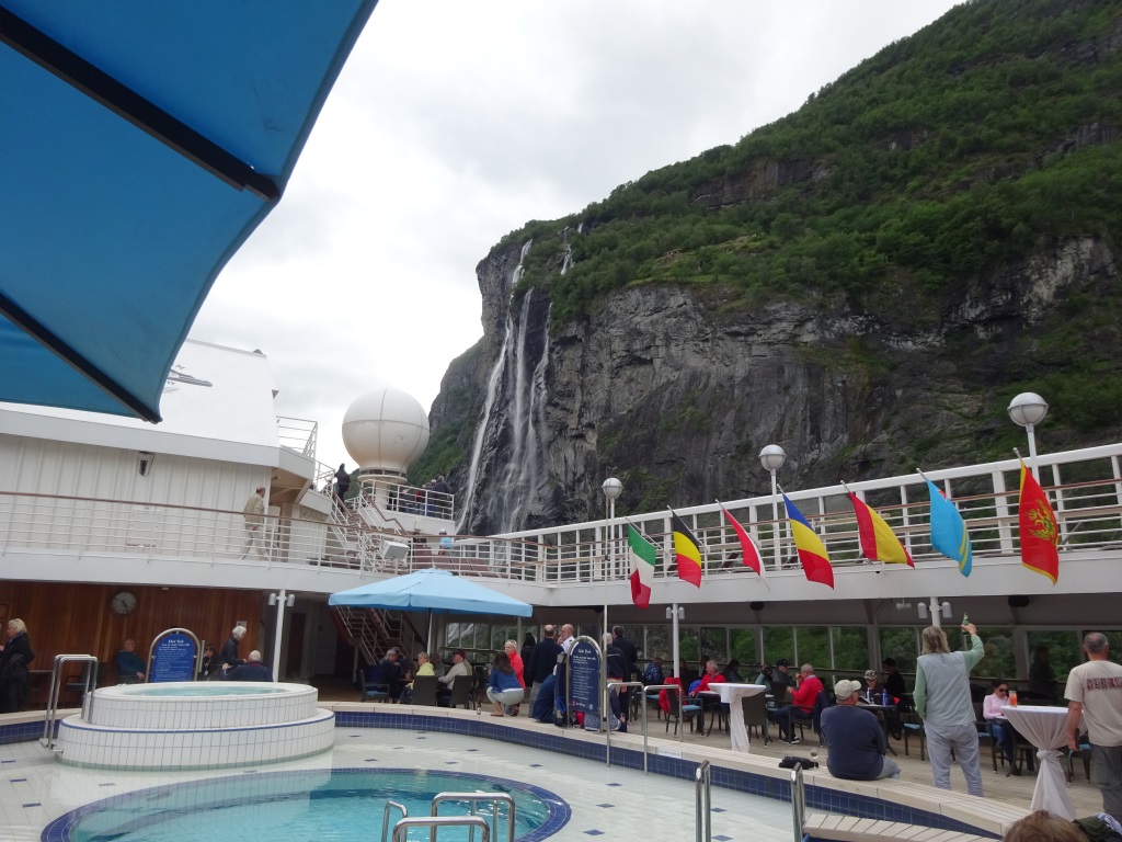
Party on deck with all the flags out, drinks, bitterballen and above it all the Seven Sisters Waterfall
With the ships officers and (guest) entertainers circulating among the guests a good time was had by all while watching the impressive scenery. It was a bit strange for me as I was always on the bridge when we were here but now being a guest entertainer for this cruise, my place was in the bar. I did not need much time to adapt myself fully to the new circumstances…………………. Continue reading
By 07.00 hrs. the ms Prinsendam was at anchor and commenced tender operations. Geiranger does not have docks, except for the small local ferries which maintain a regular ferry service inside the fjord. You can drive all around the fjord, sometimes along the fjord, sometimes high up over the mountains but it takes a lot longer than rolling your car on the ferry. I do not know if it is cheaper to do so but it certainly is quicker as long as the ferry timings connect with your personal schedule I suppose. There are several anchorages available and today all but one were occupied. There is also one mooring location on the buoys very close to town and that is normally reserved for ships willing to pay and use the Sea Walk. This is a floating bridge system (The Sea-Walk) which abolishes the need of running tenders. It is a beautiful solution for the very large ships but there is a price to pay. Today the MSC Poesia was on these buoys and she was also the largest ship in the port with an on board capacity of 2550 lower beds or a maximum of 3013 when all beds are full. Continue reading
Today we are sailing Southbound in the Norwegian Sea. And the weather is not too good but also not too bad. With not too good I mean that for the time of the year it could be full summer in this area with sunny skies and warmer temperatures and that is not the case but it is also not too bad as we do not have storm and a bouncing ship. We have some (cold) wind and some waves but apart from a gentle movement at times the ms Prinsendam is as steady as a rock. And thus we have nothing to complain about.
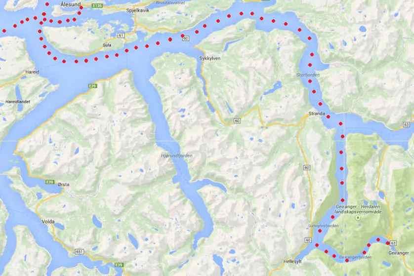
Geiranger Fjord. We will follow the dotted line all the way to the end. Geiranger pilot station both serves Alesund and the rest of the fjord.
Due to angle of the coast, the Prinsendam stays far offshore and will eventually come closer to the coast again when getting near Geiranger Fjord pilot station. That will be 2 am in the morning and then it is another 60 NM. to the end of the fjord. As we cannot race with 20 knots full sea speed through the fjord it will take much more than two hours to get to the end and thus we expect to be at the anchorage position around 07.00 hrs. Continue reading
Last night we sailed through the Inside Passage from Tromso to Narvik. There is an outside but the inside passage is shorter, more sheltered and much more scenic. About 3 hrs. down from Tromso the ship has to go under a bridge and for that you have to be the size of the Prinsendam or smaller. So the big boys have to go back outside if they would have wanted to go to Narvik. That is not often the case and it is also not that often the case with other cruise ships. This because Narvik is not really a cruise port and that is the reason why Yours Truly has not been there either. Nor my Lord and Master, and she has been out there for a long time as well on (really) small ships and she did not make it here either. But the ms Prinsendam is the Elegant Explorer and keeps going to ports to offer the guests something different, even if it is not the wildest thing in life. I am happy as I put another “dot” on my world map at home. Continue reading
Today we are in Tromso docking at the regular cruise terminal from which we can see the town next to us and also the outer part of the town opposite the river. That part has the famous Arctic Cathedral (Domkirk in the local language) and is claimed to be the most northern one in the world.
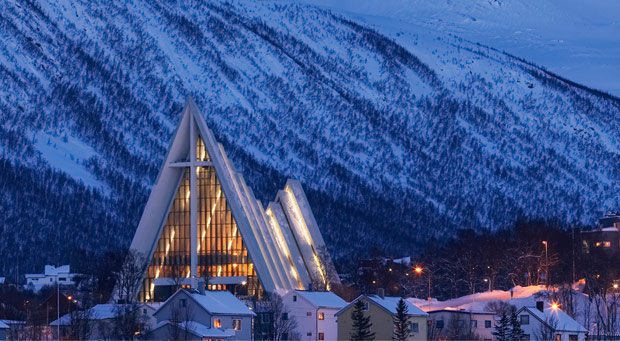
Tromso Cathedral all lit up for the festive season. (Photo courtesy https://www.ishavskatedralen.no/en/the-arctic-cathedral/)
It does dominate the landscape, something that a church normally does but in this case with its modern design even more. Tromso is split up into two parts and they have a modern bridge to connect the two sides. A high bridge so that coastal ships still can go under it. As a result it is not so easy to just walk from one side to the other side as the bridge span is long and drawn out. Hence to see the cathedral you need to take a taxi or go on a tour. Because of the inclement weather (four seasons in the hour, except snow) I decided to stay on board having seen the place in the ancient past. Sun, wind and rain changed the weather by the hour and that made it a challenging day to be a tourist. Continue reading
The wind turned to the North during the night and although that did not help with the outside temperatures, it did do wonders for the visibility at the North Cape. Seeing something here is always hit and miss with my experience being about 50/50 for seeing something or not, either the base of the Cape and /or seeing the top. But when we arrived at 08.30, it was sunny, it was bright, and it was clear. We could see the top with only a little bit of haze around the Globe Statue.
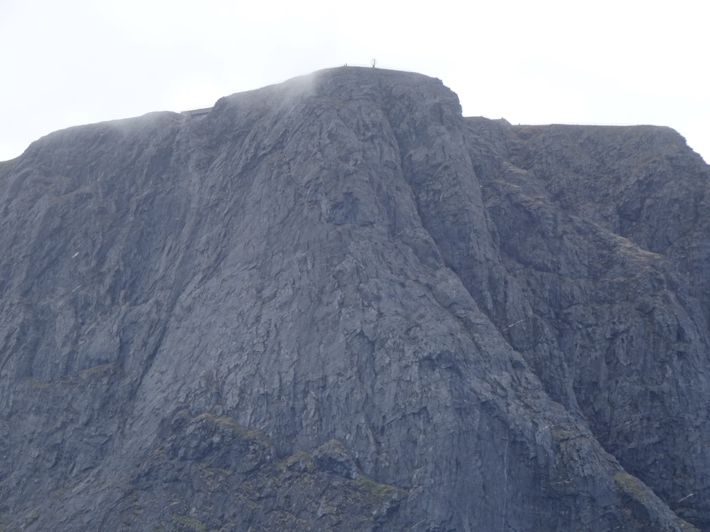
The top of the North Cape from the ship . Even the Globe Sculpture / Statue is clearly visible.
So the Captain swung the stern of the Prinsendam towards the Cape so everybody could have a good look. I was happy with a quick photo from my balcony as how many times can you look at the same Rock? From there the ship continued and sailed around the northern edge of Norway into Honnigsvag which is located in a V shaped entrance quite well protected from the winter weather. Not that it does not get cold here. It must be very cold here in the winter as now on summer’s day, the temperature only just reached 7oC/45oF; due to a northerly breeze blowing while there was not a cloud in the sky. Continue reading
Today is our sea day to get to the North Cape and Honnigsvag. The weather followed the weather forecast and it was nice, quiet and dry for most of the day. In the afternoon we got a bit of motion of the ocean courtesy to a weather front behind us which is creating some waves but the Prinsendam is a good surfer and thus the dis-comfort is very minimal. We are on average sailing a distance 12 miles from the shore. Partly because the dotted line between the pilot station of Trondheim and where we go around the corner of the North Cape makes it so, but also partly to stay out of coastal waters. There is the 3 mile zone (full territorial waters) and we try to stay out to avoid the local rules; and there is the , 12 mile zone, where we stay out of if possible as here the international regulations might vary from country to country. The latter can be quite complicated and brings headaches to every captain. IMO (International Maritime Organization) sets the standards that are approved by every member. But the regulations are allowed to be “amended by the local administration”. So a measure of a Liter of paint in Europe might be a Gallon of paint in North America, and a Jin in China. To avoid going mad and/ or making mistakes we try to plan our courses outside the 12 NM. Continue reading
Trondheim is located in Trondheim fjord which is the 3rd largest fjord in Norway. About 72 nautical miles long and the city named after the fjord is about 40 miles deep into this fjord when measured from the open sea. It is one of the most ancient cities in Norway so old that it takes at times priority over Oslo the capital city. When new Norwegian Royalty ascends to the throne, it happens here and not in Oslo and there are few more of these things. The city has a 2nd name Nidaros and for a brief period in 1930 it was the official name. Then almost a revolution took place and the government put the name back to Trondheim. This must have been a major issue as the attitude of the Norwegians does itself normally not link to revolutions. I have been told that this is still smoldering on but more peacefully as there is a split in opinion about whether the name should be spelled Trondhjem or Trondheim. So maybe one day when we come here during a cruise we will see the barricades up again, dividing the town in a hjem and a heim. Continue reading
Alesund is one of the better ports in Norway at least from a Navigators perspective. It is sheltered from most winds, it has nice docks, we dock with the gangway in downtown and downtown is worthwhile to visit. Most of it is constructed in German Jungendstil style or related to it after a big fire they had here a long time ago. There are some other good ports as far as shelter or docks or downtown distance is concerned but there are not that many Norwegian ports that have it all together. You might think about Oslo but this port is located at the end of Oslo fjord which is so wide that the wind can still blow the ship all over the place or keep it pinned to the dock. So Alesund is very highly rated on the list of ports that come closest to a Cruise Captains dream of having the best of all. And I fully agree as it even has a Big Red Bus for hop on hop off and for an initial exploration of a city it is one of the best ways to go. Holland America also recognizes that and nowadays you can buy the tickets on board. Continue reading
Captain Albert

© 2026 – Captain Albert's Website and Blog –
Theme by Anders Noren — Up ↑