Today we were on our last leg of our North Atlantic Crossing. By 8 pm tonight we will be entering the North East Providence Channel which connects to the North West Providence Channel. Whoever dreamt up those names was not very imaginative as it is basically the same stretch of water. Still it is the only gap through the Northern part of the Bahamas and it forms the shortest route to the coast of Florida and thus we are going there. As mentioned before this gap results in traffic conversing upon it and after five days of seeing barely anything, the navigators had to remember again that the Rules of the Road were there for a reason. We had now firmly the top rim of the North Equatorial current going with us and that gave us about a knot of extra speed. A little bit of free help from Mother Nature for the chief engineer’s fuel budget. It was a beautiful and sunny day with an almost flat calm sea. The stormy day from before was already quickly fading into memory. Continue reading
Category: CaptAlExport (page 127 of 203)
With the stormy day fading into memory we sailed today through the North Atlantic Ocean with sunshine, smooth seas and only a low rippling swell from the North West. We are now south of the 30o Latitude North and that means that we are in near tropical waters. This area is normally reasonably quiet as long as it is out of the hurricane season. CNN just announced that the season is over and thus it must be. So as long as Cape Hatteras is sending its depressions eastwards this area is relatively quiet as just to the south the regular trade winds are blowing. Today there was hardly anything blowing with just a gentle breeze touching the top of the waves. This has the pleasant result that the guests can enjoy two glorious sea days before they disembark in Fort Lauderdale. Apart from have the option of a very full daily program, the outside of the ship is becoming more and more interesting as well. In the past few days there was not much to see at all, apart form the occasional seabird. Now ships are appearing on the horizon again as we are coming closer to the normal shipping lanes. Continue reading
By 3 am. the swell direction did indeed change and then came from a more Northerly direction. So the pitching of the ship accompanied by the occasional banging changed into a more “swaying” movement. Officially it is called rolling, but it did not really do that. The ships stabilizers kept the Prinsendam nicely upright but occasionally a large wave would lift the whole ship up and moved it with her, until the wave rolled away from the ship and the ship would return to its normal position. It gave a sort of a swaying feeling. When the ship then returned to a normal state the bow would dip into the waves and occasionally slam. The issue with this movement is; that there might be prolonged periods of a steady ship in-between. Then there is suddenly this sway, followed by a slam and then it is all quiet again. If the ship has a constant strong movement the guests can anticipate it and prepare for it. With an occasional sway without a rhythm that is much more difficult. Thus I made an announcement at 08.30 to advise all around that this swaying would last into the early afternoon. Reason to be careful and not to be “swayed” into false confidence because of the irregular and long delays between each sway. Continue reading
It is becoming monotonous but again my first action of the day was to check the weather forecast to see how this “Cape Hatteras special” was developing. Especially, how far was the wave field going to come down towards our course line. Well it did not look that good. We were going to have a bit of fun during the coming 24 hours. Based on the projection of the next 36 hours we would have to sail through the 4 meter field. These 4 meters are the significant waves which mean the average wave height. Thus there will be lower waves but also higher single waves in-between. The good news was that my course change of yesterday would keep the ship out of the 5 and 6 meter regions. As already explained that was as much as I could do without loosing too many miles. Based on the swell chart, the waves were going to hit us in the mid to late afternoon and it should last until tomorrow afternoon. I am writing here constantly of waves, as those cost me the most speed and also the most inconvenience for the guests.
However waves are generated by wind and wind we had as well. Lots of it. Continue reading
It was a nice day, although it started with thunder and lighting and clouds that emptied a considerable amount of hail stones onto the ship. Luckily it lasted only a few minutes and then the frontal system was past and the skies cleared. Good timing as well; it cleared the ship from the salt and it was early enough in the morning to avoid guests being affected by it. Although a few guests, having breakfast on their balcony’s, had a wet surprise. Maybe we should install a little red light on the balconies. If it is on, it will indicate to stay away from the outside as wet surprises are on the way. My first chore of the day was to check my weather charts again and this time the picture looked a bit ominous. As expected Cape Hatteras was producing the next storm system but there is a fair chance that it will get pushed downward into the North Atlantic Ocean by the one but last system that is slowly moving towards the Hudson Bay. It looks like it that Cape Hatteras is sending system one straight across, then a system up north towards North Canada and that system is then pushing system number three to the south before it can hitch a hike on the jet-stream which propels it east towards Europe. The un-answerable question for now is, how far will it come down towards us and how much will it deepen in intensity. That will dictate the strength of the wind and that again will dictate the height of the waves. Continue reading
At 7 am. I switched on my computer and all was revealed. In the late afternoon of the day before two bad weather systems, both generated near Cape Hatteras, had merged and its combined force was sustaining the swell running South East over the North Atlantic and in our direction. One system had been moving North West in the direction of the Hudson Bay; it had stalled and the next one travelling east caught up with it and they merged. As a result we travelled for a while through a much stronger and higher wave field than was indicated in the weather forecast. However during the night the ship settled into a more steady movement, a bit wobbly but very good for a North Atlantic crossing especially in November. Now I have to keep a close eye on the next “Cape Hatteras development” and to see if that will affect us as we sail further west. Most depressions generated there go straight across to Europe but the wave fields tend to spread out and also come south. If the storm is strong enough it might reach us and that will cause inconvenience and also affect the ships speed. At the moment the movement is such that I am nicely on schedule but the light pitching does take some of the speed away. That is the amount of speed that normally gives me some “plus” for the case of. I am now waiting for the Azores current to come through as that should give me .5 knots extra. Then later the ship should hopefully pick up the north boundary of the North Equatorial current that eventually becomes the Gulf Stream. Continue reading
Crossing the North Atlantic means a whole change in the way of looking at the navigation. Instead of little stretches between ports, where you have to go weather or no weather; the vast expanse of an open ocean gives more options. Decision number one to make, how will I cross the ocean? There are basically two options. Via a straight line, called a rhumb line, or via a curved line, called a great circle line. The last line is the shortest route as it carefully follows the curvature of the earth. The rhumb line is the longest route but can have the advantage that you stay at a lower latitude and thus a larger distance away from bad weather. When we crossed with the Prinsendam in spring 2009 from the USA to Europe, I used the Great Circle route as Cape Hatteras was fairly quiet and there would be only following winds if something would happen. Now it is November and we are going the other way. Thus I opted for the Rhumb line as it would bring the ship as far to the South as possible; as far away from the bad weather generated near Cape Hatteras as possible. That does not mean that I will escape it if it comes my way but at least I have then put as much distance between Cape Hatteras and the ship as possible. In this case we will have to cover an additional 39 miles, caused by the longer Rhumb line route. That we can absorb in the six day crossing without much problem as the total crossing distance is 3357 from Funchal to Port Everglades Sea buoy. Continue reading
As part of the continuous upgrade of the Prinsendam, the ship received 320 new cabin chairs during the call at Barcelona on 15 November 2010. The new chairs have a slightly higher back but most importantly are more fire retardant. Chief Officer Ryan Whitaker, in charge of interior maintenance, asked the agent in Barcelona whether a charity would be willing to take the 320 old chairs coming of the ship, which were still in good condition.
The charity that responded was La Nau, which specializes in collecting non-food materials for the socially excluded. Items obtained are cleaned and repaired and then forwarded to welfare organizations. Thus retirement homes, orphanages, night shelters, etc., will now all benefit from our gift. As can be seen from the photos, Housekeeping and the Deck dept. set up a system whereby the old chairs were removed from the cabins and unloaded in the morning and the new chairs loaded and brought to the cabins. Before departure all guests had a new chair to sit on. The carton was recycled on the dockside at the same time and thus did not have to come on board.
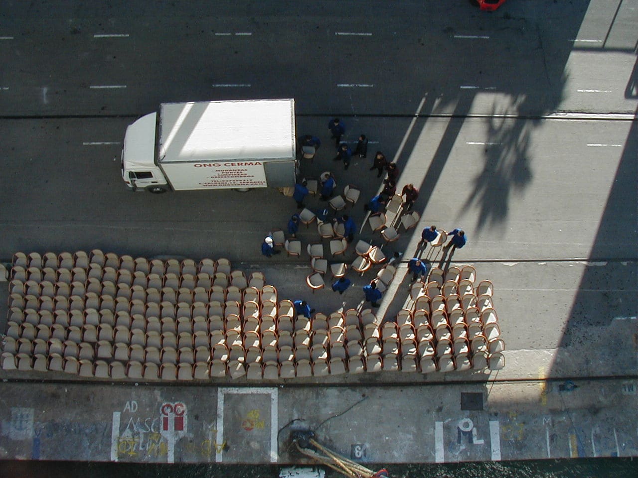
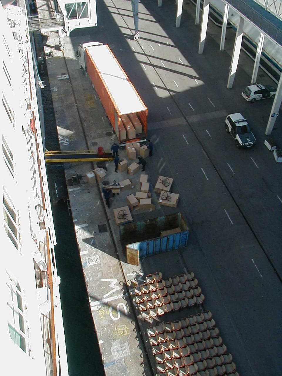
At Barcelona, Spain.
Albert Schoonderbeek is master of Prinsendam.
Funchal is one of the easiest ports to dock at, as long as there is not too much wind. The dock is just an L shaped breakwater sticking into the sea parallel to the coast. Madeira, is nothing else than a mountain top sticking above the sea, it rises very steeply out of the North Atlantic ocean and the area in front of Funchal is just a little platform about 30 meters under water and thus ideal to build a port on. They figured that out already 100’s of years ago and since then the port of Funchal has been the lifeline for Madeira and responsible for its prosperity. The docking is made easy as the whole port area is deep so the ship can approach quite close to the coast and then turn to a westerly course and slide parallel along the dock into position. Leaving is even simpler, if you are docked at the end of the breakwater you only have to go astern the length of the ship and then turn the bow to port over the end of the pier and you are back in 1000 feet deep water and safely clear. Continue reading
Thus we started our Trans Atlantic crossing by leaving Cadiz on a wind still and moonlight night. The Cadiz pilot had already forecast that Cadiz was in for some rain and we saw that rain clouds were gathering at the horizon; early this morning it also came over the Prinsendam, courtesy of the tail end of a weather system that is moving over the North of Spain. However that weather system was going North East and we were going South West and logic demands that eventually you have to run out of it and that we did by noon time. The accompanying winds of force 6 to 7 disappeared as well and by late afternoon it was wind still and sunny. Also the predicted forecast of about 8 feet of swell proved to be true and thus the Prinsendam moved steadily through the ocean with just the slightest hint of pitching. It is always nice when the weather follows the weather forecast especially if it is a good forecast. Continue reading
Captain Albert

© 2026 – Captain Albert's Website and Blog –
Theme by Anders Noren — Up ↑