One of the things that cruise schedules and brochures have introduced is that cruise companies refer to smaller ports of call by the name of the island instead of the name of the place visited. That is nothing new, they already did so in 1900 when the first real cruises were made. (See the story of the Victoria Luise elsewhere in the blog site at: Of Days gone by) When a ship goes to New York or to Charleston, we say that we are going to New York or Charleston. We do not say we are going to North or South Carolina or to New Jersey or to Upper State New York. But as soon as we go Island Cruising it becomes the Island. We go to St. Thomas and a lot of cruise guests do not even know or remember that the ship called at Charlotte Amalie. We go to Barbados but why do we not go to Bridgetown?? I have never figured that one out.
So today we called at Grand Turk Island which forms part of the Turks and Caicos Islands. The name Turks comes from a Turkish cap, called a Fez and that comes from a Cactus whose top looks like this Turkish fez. For the rest it has nothing to do with Turkey what so ever. Contrary the islands are part of the United Kingdom. The main town on the island, just north of the ships docking pier, is called Cockburn town and thus that is officially the place we are visiting. Although a lot of cruise guests did not go there and were quite content to stay in the especially made resort at the end of the pier.
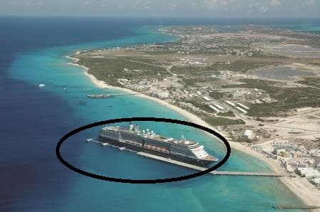
The ms Noordam docked at Grand Turk during the inaugural call for Pier & ship. Note that the encircled area s the only deep water space available for the ship. Not much more than two ships widths.
The pier construction was sponsored by Carnival Corporation and as a result the whole setup looks similar to Mahogany Bay and other Carnival designed or influenced piers around the Caribbean. It was opened a number of years ago with our Noordam being the first ship to call there. The pier can handle two large ships at the same time and then there is room for a 3rd ship at the anchorage but that is really weather – very good weather – depending. The anchorage is very exposed to swells curving around the island from the north and the south and from the Trade wind which blows over the island. This is one of the reasons why the dock is there. It is a nice port of call but for anchoring the weather is often not good enough. Build a pier, send ships with strong thrusters and you have a much higher chance of making it when the weather circumstances are less than perfect.
Today the weather circumstance were not ideal, although the weather guru’s, see my yesterdays’ blog, had promised sunny if windy weather. Today we got a bit of everything as a weather front dipped further down than was foreseen and provided: sunny and calm /early morning followed by rainy and wind /middle of the day and then windy and very bumpy waves near the end of our call. This would not have been a pleasant day if we would have had to anchor here. But we docked and as the rain is not so cold as at home, we could all live with it.
Arriving in windy weather here can be a challenge as they have only dredged a small area on both sides of the pier. No more than a double ships width. Thus there is very little room for drifting and that means you need a lot of power available to go sideways against the wind when you slide a ship alongside. Leaving is less of an issue. While going astern you can keep increasing speed all the time and the more speed, the less drifting and before the wind can get a good grip on the ship it is in open waters again, where drift is not an issue.
And that is what was done this afternoon. With the swell banging under the stern, the Eurodam popped like a rocket out of the docking area and back into open waters. From there the ship sailed around the north point of Grand Turk to the East and then South East, heading for its next port of call San Juan, Puerto Rico. We are scheduled to be docked there by 13.00 hrs. and stay until 23.00 hrs. when will make our hop to next door, St. Thomas. (Officially Charlotte Amalie, Havensight pier)
Expected Weather: Sunny 82oF / 28oC ………………. Although we have to see if that works out. Predicting the weather for San Juan is very difficult. Most of the island is covered with a dense Jungle type rain forest which creates its own micro climate around the port. You never know exactly what will happen during the day. Apart from being sure that it will be warm, a safe bet is always that the sun will shine but there will be at least one moment of liquid sunshine during the day. We just have to hope that that moment will be in the morning when we are not there yet. The weather gurus are predicting mostly sunny skies and a North Westerly wind of 11 knots. Normally the wind is the easterly trade wind but if the wind is still North West, caused by the passing frontal system of today then we have a fair chance that that wind will push all the rain clouds to the south and it will stay dry all day.

February 20, 2017 at 5:38 pm
I a so happy to be receiving your blogs again. I have missed my
Bed time reading, happy sailing
Best wishes Robina