The ship kept behaving quite lively during the night and then during the day. But by mid afternoon the seas settled down somewhat as the winds, which had abated last night, did not provide the energy anymore. We had a nearly windless morning but the still high seas; I saw a few going up 17 feet, and it made it feel like as if we had bad weather. Most of our guests kept a low profile and that gave rise to my cabin steward complaining that he could not get in any of his cabins. Still somehow he managed as he reported that by 14.00 hrs. he had serviced them all. Bad weather makes it hard for the Cabin Stewards as they have to service all their cabins, and work around the different times that the guests are going out. Their break time is at 14.00 hrs. and they start again around 17.30 so if the guests are not leaving, they try to wait past 14.00 hrs. and then it will eat into their break time. Most guests are quite understanding if their – stay in the cabin- results in their cabin not being made up in the morning but not all of them.
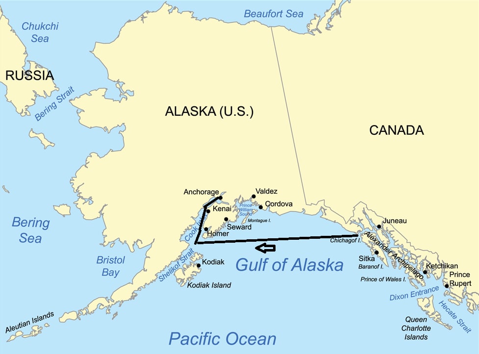
This was our route from leaving Icy Strait Point and sailing towards Anchorage. We had most of the high waves and wind in the area where the map reads “of Alaska” Once coming closer to Kodiak things settled down again. We will visit both Homer and Kodiak on the way down.
We had most of the ships movement while in the curve of the Gulf of Alaska before passing Cape St. Elias. This makes sense as most of the long waves come all the way from Japan and roll in a North Westerly direction towards Alaska. Hitting land in the area of Glacier Bay. If the bad weather has only been near Japan, then the waves are quite sedate by the time they arrive at the Alaskan shores and the ship does not move at all or only has a gentle motion. Very good for taking an afternoon nap. If the wind is also blowing over the Northern part of the Gulf then that wind keeps energizing the waves, and can build them up even higher, then we get the wobbly weather which we had today. The more you sail to the west, the more you get out of that North West wave direction and the quieter it gets. The Kodiak Islands offer quite a nice protection as well.
This does not mean that there is no bad weather near the Kenai peninsula, far from that, it is just that often the waves in the area close to the east side of the Kenai peninsula are a little bit less pronounced as there is some shelter from the land. That is with the waves, read swell, coming from lower parts of the North Pacific Ocean. If you have a full westerly storm thundering over then it is mayhem everywhere. But today we were in the position that the swell slowly started to abate once we came closer and closer to the Kenai Peninsula. And once we rounded the southern point of the Peninsula the swell was completely gone. That was good planning as it gave those who had “been under the weather” to come out and have a good dinner. And dress up at the same time as it was formal night.
The amount of wildlife in the area, as far as whales are concerned, has been less than what we normally see. The bridge officers are reporting that the migration of the whales, either to Hawaii or to Cabo had started a few weeks ago and now most of them are gone. Why, I do not know, they do not always leave at the same time; meaning the same week each year. I have seen large amount of activity until well in October in the past, when my ship was the last one leaving the coast. But I did not see any whales at all today. First of all, they do not seem to like high waves as I have never seen them swimming on the surface when there is a swell running of 15 or more feet and secondly, by yesterday afternoon we were more or less away from their track down to Hawaii.
Anchorage is located all the way up the Captain Cook Inlet and that means that we will stop off at Homer to collect the South West Alaska Pilot who will guide the ship all the way up the fjord to the dock. Because Cook Inlet is a sort of estuary and gets smaller and smaller when coming closer to Anchorage, the water has to go somewhere when the flood comes in and if it cannot go sideways it has to go up and that results in large currents and high tidal differences. Just after midnight tonight it will be low tide and thus the ship has to go upstream against the outgoing flow during the evening. Luckily then we get the flood in the back and that will help with arriving nicely on time.
Weather for tomorrow: Overcast with rain, 11oC / 51o Fahrenheit. No a great day but there is no wind forecast so there should be no wind chill factor to make it worse.

September 18, 2017 at 2:45 pm
Oh, we know that feeling very well crossing the Gulf as we had more of a rolling sensation on Veendam’s south bound run to Vancouver with the wading pool aft giving some lively performances and surprising a few guests. Fun to watch. Thanks for your postings. We are looking forward to the 14 day run hopefully in 2018 if my wife’s health holds out.
September 19, 2017 at 12:10 pm
Captain A,
You commented that the seas were running up to 17 feet and later you said swells at 15 feet. Is there a gauge on the bridge that tells you this or simply a matter of decades at sea and observing from the bridge?
Thanks,
Roger T
September 19, 2017 at 12:51 pm
Good morning,
Good catch. We had the seas and swell combined up to 17 feet, but on average they ran at around 15 feet and of course a few times it was less when the wave patterns cancelled each other out. Swell is seldom strictly from one direction. No we do not have a gauge on the bridge to read anything. I do not think that would even be possible as it would require a stable platform and the ship is going up and down with the waves. So it is a matter of looking out of the window and using your experience. That is something you learn through the years, from older Sea Salts, from the standard classification which comes from the wind that is blowing but also from picture books issued by the various Meteorological Institutions where you can compare wave heights with the height of the masts of the ship in the photo.
Thank you for reading my blog and best regards
Captain Albert