Well this cruise started very well. The sea was as smooth as a mirror when we approached Half Moon Cay and the sun was happily shining with just a few clouds in the sky. I had been told that we would be the only ship here but when we arrived the Nieuw Amsterdam showed up as well. I should have checked myself as it is clearly on the sailing calendar. With two ships in there could be about 4000 guests ashore but in reality probably no more than 3000 as a lot of our guests have been there already a few times and opted to stay on board. And that means that the island is still very sparsely populated and there will be no fights over beach chairs. Continue reading
Page 31 of 240
With so many cruise ships coming in, and so many big ones, the arrival parade started quite early as some ships docked nose in and some ships docked nose out. The choice between one and the other has mostly to do with work that has to be carried out on a specific side of the ship. All captains like to dock nose out; always easier for departing. Most of the time you have sufficient time on arrival to swing first before docking as Customs and Immigration do not start until 07.00 hrs. But captains do not always get their way as work might be needed at a certain side of the hull. Continue reading
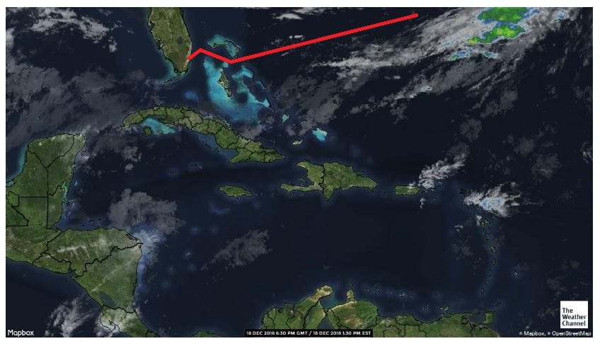
With a brightly shining sun the ms Zuiderdam continued its return part of the voyage to Fort Lauderdale. We have already left the North western part of the Caribbean with the Yucatan Channel and by 16.00 hrs. we were abeam of Havana Cuba in the Straits of Florida. In the Straits the navigators start searching for the most optimum speed by trying to find the center of the Gulf Stream. For this we are aided by current charts which we receive every day from the NOAA and from other Meteorological authorities who collect Satellite Data, then turn the data into charts and beam them on a daily basis to everybody who can receive them. Continue reading
Today we had our first sea day with beautiful weather and it looks like it will remain so. The frontal system of yesterday dissipated and the next one coming will only bring thunderstorms on Monday and we will be in Ft. Lauderdale on Sunday. And that should be a warm day as normally between systems the wind dies down. The route we are taking runs roughly along the east coast of Costa Rica, Nicaragua, Guatemala and Mexico before we reach Cuba and the Straits of Florida. I use the word roughly as it is not a straight course. Continue reading
Puerto Limon is one of the two major ports in Costa Rica. There is a 3rd one Porto Moin but I have been told it is too obscure for cruise ships. One port is located on the west coast, Puerto Caldera with attached to it Punta Arenas cruise terminal and on the East coast there is Puerto Limon. Limon is not really much of a port. It is just a corner of a large bay with a cargo pier at the north side and a newer pier with two berths next to it. The cargo dock is lying inside the natural sea wall and that is not for nothing. The coast here is a real surfer’s paradise with swells that built up very high and then roll freely into the bay. Very exciting for surfers who come in droves to this coast to ride the waves. Continue reading
The Zuiderdam has been sailing on this service for quite a while and hence the Captain and his team have become experts in dipping into the Panama Canal and out again. So today was pure routine, although it was a hot routine. Although it was somewhat cloudy at times, the sun burned down upon us all day and there was not much wind to help cool things down a little bit. That was a pity; but on the other hand it is also good as a cool breeze gives the impression that it is not so warm and then the next morning you find out that it was very warm and sunny when you start to imitate a well-cooked lobster. Continue reading
When there is bad weather in the offing, then as a captain you always have to decide: how much are you going to tell the guests, how much detailed information to be given, what is enough to prepare them without confusing the message. Once you have done that, the waiting game starts until the bad weather comes through and you can find out how good your predictions were and if real life –ship in storm- equates to the guests perspective. The understanding achieved by the warnings given. There is no captain in the world who minds to be called a liar if the weather is less bad than he/she predicted but at the same time there is the nagging feeling of will they believe me next time or will they just think that I am always exaggerating. Continue reading
11 Feb. 2018: At Sea.
Yesterday I boarded the ms Zuiderdam in Willemstad after having been on vacation since December 18 after leaving the ms Nieuw Statendam when it ended its maiden voyage in Ft. Lauderdale.
During my vacation time, the IT gurus of Holland America have been moving my blog to a separate server for operational reasons. It should not have affected anybody as I am still linked through via the HAL blog but you can also reach me via www.captainalbert.com.
Never a dull moment when you work for Holland America. Continue reading
Thus today we have the final day of our crossing and also the final day of our cruise. They say that all good things must come to an end unfortunately, and thus also this cruise. I think it has been a good cruise as the weather was very good for a December crossing and the guests all look happy and the comments are positive. So we can say without doubt that the Nieuw Statendam will be an appreciated new member of the Holland America family for many years to come.
The last remnants of the frontal system of yesterday passed by through the night and today we had a regular nice sea day with partly cloudy skies and pleasant temperatures. The storm chart only gives flat seas; the rain chart does not give any rain at all, except for the system we have already passed. Also Fort Lauderdale is promising to be a dry day. With 25oC / or 73oF. and very little wind.
The Radar chart with the cloudiness in the area. There are some rain clouds far away but they should only reach Fort Lauderdale after the ship has departed.
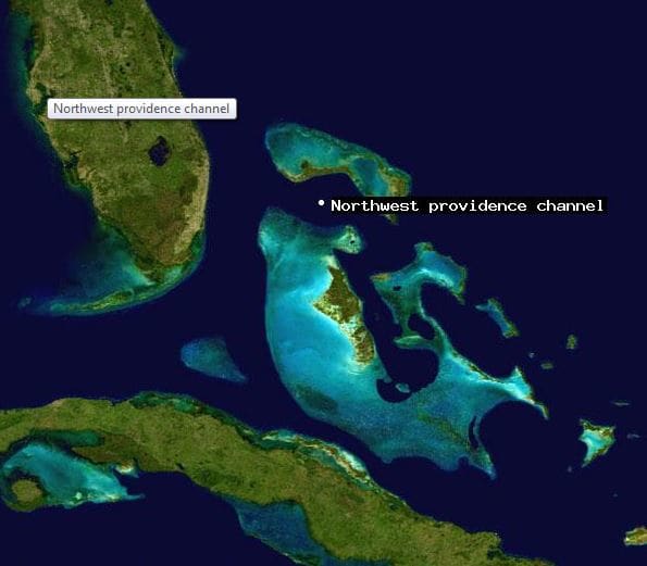
This evening at about 18.00 hrs. we will enter the Bahamian chain of islands and then sail through the North West Providence Channel towards Fort Lauderdale. For that we have to cross the Straits of Florida. As Fort Lauderdale and its port, Port Everglades, lies a little bit south of where we come out of the Bahama Banks, we have a South Westerly course to aim for. That course will become more and more south westerly as we have to compensate for the Gulf Stream which is pushing north. The Gulf Stream is our friend and sometimes our enemy. Depending if we sail with the current or against the current.
Now we are dealing with the current under an angle, so the navigator only has to figure out the right course to compensate for the drift. The second interest is to find out where the axis of the Gulf Stream is located, there where the current is at its maximum velocity. This is called the Gulf Stream axis and if you can find it then you will get the benefit of the “big push” when sailing in the same direction. If you go opposite then knowing the location helps you with devising a course as far from it as possible. The NOAA normally publishes a 3 day update as the Gulf Stream moves on occasion in the Straits and that can really be from all the way up the Florida beaches to all the way against the Grand Bahama Bank. And nobody really knows when it moves and why it moves. If some clever clog would be able to figure it out, then we would be able to get much more accurate data than we have now.
So crossing the Gulf Stream is basically a task of keeping an eye on the ships position and the “set” of the ship to the north and compensate for it accordingly. Normally we are out of the Gulf Stream influence when we are about a mile away from the Port Everglades Sea buoy but I have seen it that the current ran full force just outside the breakwaters and that we went into the port under a considerable drift angle. So much that even the local pilot got nervous. The simplest solution is then to go in a bit faster as that reduces the drift angle. Once inside the breakwater there is more than enough distance to slow down again. The harbor master likes 10 knots in the channel, but if the current or wind is strong, the ship will go a lot faster to reduce the drift angle.
For the purpose of sailing under an angle and remaining in the middle of the fairway, they have installed a set of leading lights to help. The only challenge is they sometimes have parked a tanker in front of it and then the lower light is obscured. When the light was put in, the tankers were not as wide as they can be nowadays. We will be lining up in those leading lights tomorrow around 03.40, a few minutes after we have boarded the pilot. From there it is only a short hop to the dock as the captain has decided to go alongside starboard side, nose in, at Pier 26 and thus we do not have to swing on arrival. Once alongside that whole circus will start which I described a few days ago. I will be helping out to make that all go smoothly by getting off the ship ASAP and thus ensuring that the zero count does not get delayed.
And that brings me to an end of my blogging period on board the ms Nieuw Statendam. I hope you have enjoyed my daily musings about the progress of the ship towards its completion and the first two cruises which proved that the ship is a great success and a genuine asset to the company.
In January my blog will be relocated to a new server. This should not affect anybody at all but in case there is a hiccup you might have to refresh your automatic link to the blog. My first ship in 2019 will be the Zuiderdam which is on the schedule for Feb. 10. and that is also the date that my blog will recommence.
Thank you for your interest and support and Happy Holidays.
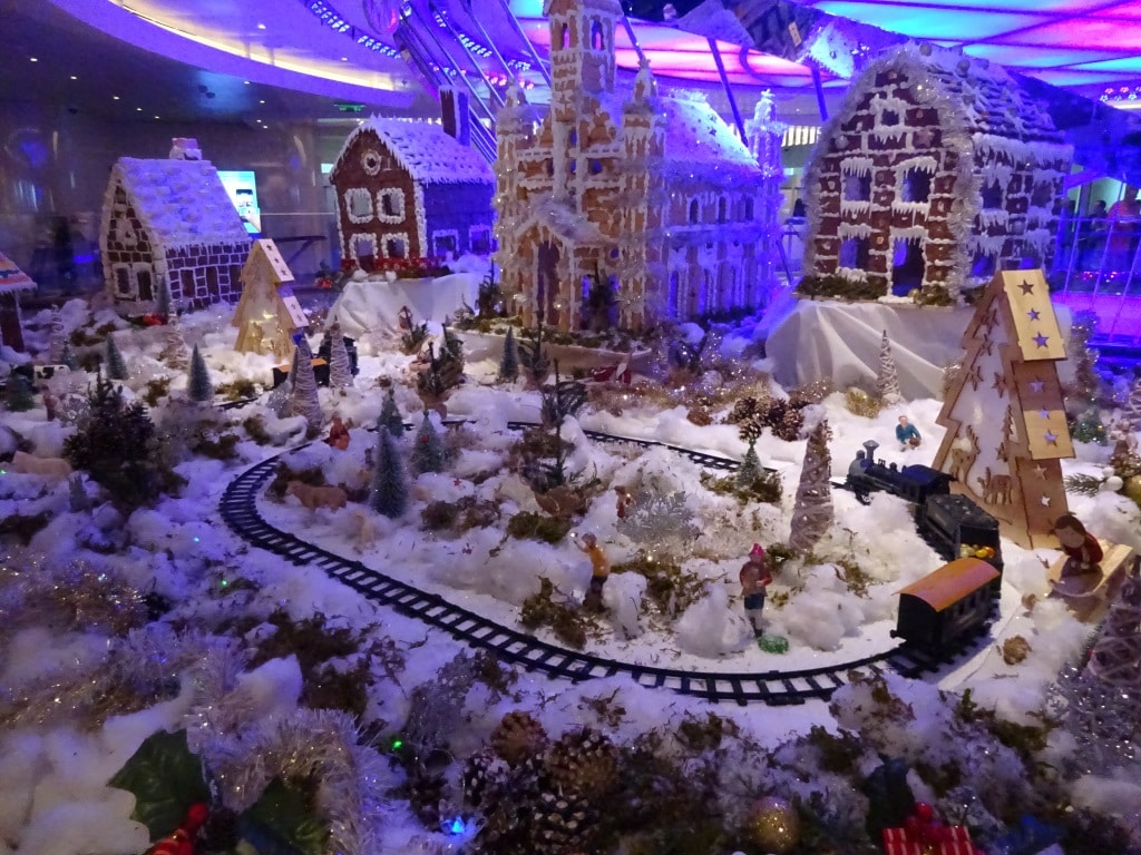
This is the magical piece of Christmas nostalgia which the Pastry Department on board has created. This is only part of the whole display. It is about double the size, including two trains. Setup outside the Grand Dutch Café for all to admire.
Today we are exactly a week at sea and we are almost there. North West Providence channel is now rapidly coming closer and that is where we will see land again for the first time. Bahamian Islands to starboard and to port, visible to eye if the weather is clear.
Here at sea the weather was not very clear and Mother Nature had decided not to listen to what the meteo guru’s in their infinite wisdom had pulled out of their computers. On a wide open ocean, it does not take very much to change a regular pattern of weather. And that is what happened last night. I was bravely hoping for a real Caribbean day, with lots of sunshine, and what we got was still a Caribbean day but the rainy version. A long band of rain had been laying over the east coast of Florida and it was supposed to come over tonight. No problem for us, everybody inside enjoying the music walk and the Bo ‘sun outside enjoying that his ship was de-salted free of charge.
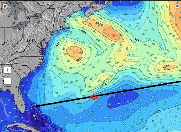
Quiet times at Cape Hatteras. Patches of 12 feet of swell is really nothing compare to what it is capable of.
But the frontal system decided to speed up, most likely caused by the fact that it is unusually quiet at Cape Hatteras at the moment and the weather system was not pulled that way. So it came our way and all morning dark and gloomy clouds were surrounding the ship and on occasion also descending upon the ship. By lunch time it started to clear up but it will not be before tonight that it should all be gone. Unless the weather front decides to stall, then we will still have some of it tomorrow. But still, the seas are fairly calm, we just have some chop and wind caused by the weather front and the ship is riding nicely through it all.
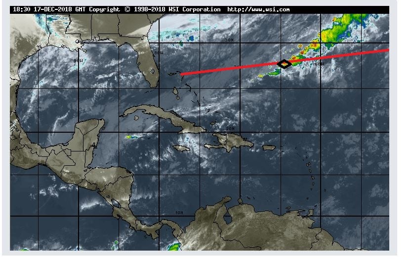
And this is the rain picture we sailed today through the lower tail of the weather system. (Photo courtesy www. Weather.com)
A guest commented today, that he has seen so few ships since leaving Funchal, and he was correct. Although there are plenty ships out there the area is so vast that even if they go the same way, they might just be outside the range of the eye. The earth curves and thus you can only see so far. On the bridge which is about 75 feet above water, we can see between 10 and 15 miles depending on the clarity of the air and the size of the object. At night we can see ships about 6 miles away as that is the requirement for the strength of their navigation lights. On our commercial radars we can pick up a ship at 48 nautical miles and sometimes even up to 96 miles. The Navy has much better gadgets again and can do several hundreds of miles without any problem.
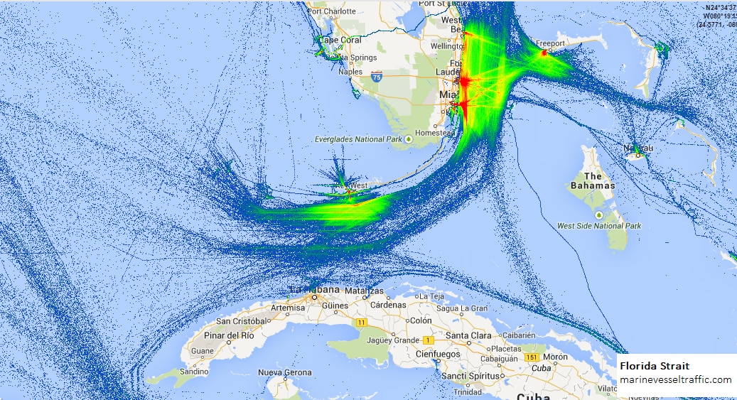
This is a shipping pattern that you can plot if you keep adding the transponder trails to the same route over a period of time. It shows most of the traffic near ports and a general trickle going South East of Freeport, there were we are coming in.
But the main reason for not seeing many ships is, that our route is not a main shipping route. There are not many ships who ply between Funchal and the Bahamas and thus we are really alone. This route only sees traffic in spring and autumn when the cruise ships are migrating. Most ships coming from or going to the American continent, follow the Gulf Stream and make an educated guess between sailing in the nicest weather (and making good speed) or taking a bit of turbulence (and losing some speed) if in the balance they still make the best time. Cargo ship engines are the most efficient when going full speed. So those ships race full speed to their destination and when they arrive, drop the hook if they have to wait for a berth. Then the expensive main engine goes off and a small auxiliary or donkey engine provides the little bit of power that is needed to keep the ship going. So for them it is not so important to have nice weather but combined circumstances that equate to the lowest fuel consumption. The Gulf Stream in the back helps them save a considerable amount and thus they start their crossing most of the time just under Cape Hatteras. That does not give the best of weather but they will have following storms and that does delay a ship much less than have to battle against a storm.
A nice aerial photo which shows the Grand Bahama Bank, the islands and other sandy patches. (Photo courtesy NASA, so I assume this was taken from space)
Tomorrow is our last day at sea. Then in the late afternoon we will enter the Bahamas, between South Abaco Island to the North, and Eleuthera Island to the south. The body of water is called the North West Providence channel and are near the gap on the Abaco Island side is called the “hole in the wall” quite appropriately.
Captain Albert

© 2026 – Captain Albert's Website and Blog –
Theme by Anders Noren — Up ↑