With a brightly shining sun the ms Zuiderdam continued its return part of the voyage to Fort Lauderdale. We have already left the North western part of the Caribbean with the Yucatan Channel and by 16.00 hrs. we were abeam of Havana Cuba in the Straits of Florida. In the Straits the navigators start searching for the most optimum speed by trying to find the center of the Gulf Stream. For this we are aided by current charts which we receive every day from the NOAA and from other Meteorological authorities who collect Satellite Data, then turn the data into charts and beam them on a daily basis to everybody who can receive them.
Most of the charts are free and in the public domain but some of the highly detailed ones are by subscription only, as somebody has to pay for this vast array of satellites that are being used to collect weather data. Some of these companies have the option to collect information data (because they also pay for it) from all sorts of sources, American, Russian, Chinese, and European without politics getting involved. Holland America also subscribes to some of these organizations and we have more than one as each of these companies has special expertise in certain areas. The most important one is WRI or Weather Routing Incorporated and the subscription we have with them, enables us to import the planned ships track straight into the routing program, so the ship sails through the actual weather chart. I cannot put a current map on the blog, copyright is a hot potato here, but the below gives a good idea.
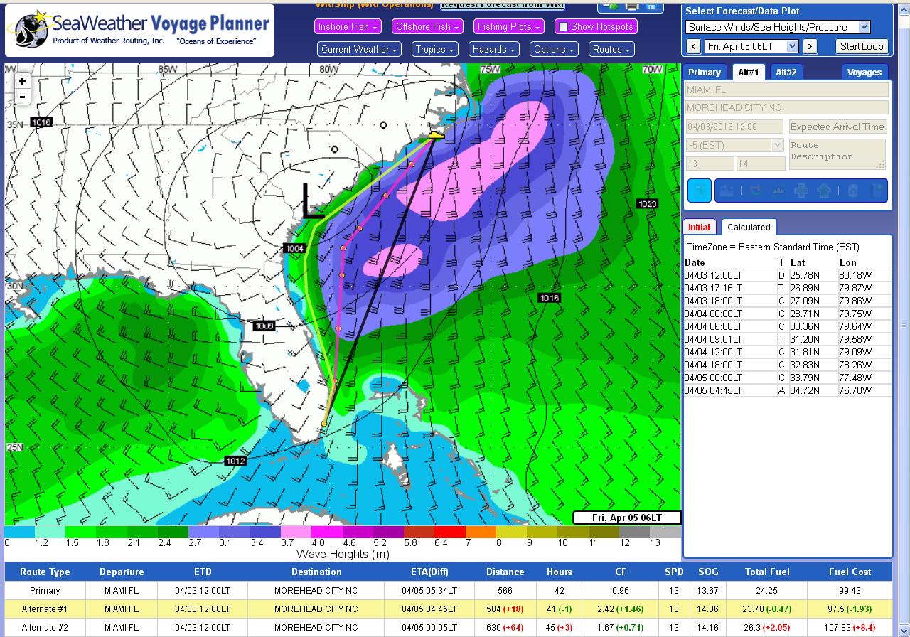
A sample page of the weather services offered. The black line is the intended course. The pink line is the advised route to avoid most of the bad weather. It is a longer route but as the ship will not be slowed down by the bad weather it might still be faster. Plus there is the bonus of a little extra push from the Gulf Stream.
This is a routing map from Florida to the New York area. And apart from the weather, they also predict ocean currents. So yesterday the captain could play on the computer screen with the intended route of the Zuiderdam and by moving the route a little bit to the West or to the East catch the best current for approaching Cabo San Antonio, the west point from Cuba. This is a feature called Cruise Surveillance and that gives 24 /7 actual weather and current information. Plus the system rings the bell, if there is something nasty coming with options to do something about it.
It all helps to keep the guests safe but also happy as we get real time information provided by the constant stream of Satellite data. That does not mean that we do not rely on our own observations anymore. The navigators look out of the window and when possible do something that is peculiar to the cruise industry; we sail around rain clouds. Nothing is more irritating for guests if they sit happily in the sun and then suddenly get drenched by a rain shower. In the Caribbean Sea that rain might be warm but it is as wet as it is at home. But while at home your house is stuck and you get what Mother Nature pushes your way, at sea we can see the edges of the rain down poor and if the width of the cloud is not too much, we can sail around it.
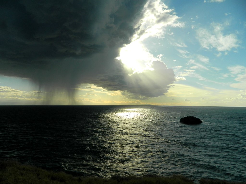
A rain shower somewhere in the Mediterranean. The edges of the rain coming down are quite well defined so depending on the direction the rain clouds is traveling the ship can go to port or to starboard to avoid all of it or at least most of it. (Courtesy, unknown photographer on the internet who took this photo near Lipari Italy)
When I started sailing in 1981 for Holland America things were not yet as strictly regulated as today, so we had a lot of leeway to play around with the ship. And we developed a sort of competition between the watches to see how close we could sail past a rain cloud without getting the ship wet. The first prize was for the navigator who stayed dry but with sticking his arm out, outside the bridge wing, could feel the rain. To ensure that there was no cheating or telling fibbies, the Quartermasters (our helmsmen) were the official referee’s. Still it was a bit of luck if you managed to achieve that as rain clouds move as well and not always with the same speed; and there is always wind in the clouds and that can change the equation also. But it was a nice diversion in the days that the Statendam IV plodded happily on 10 day cruises from Miami down into the Caribbean.
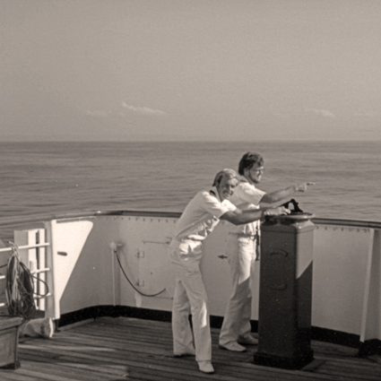
The good old days. Yours truly with colleague, navigating. No radar or electronic chart. We used the bearing compass and a paper chart. SS Statendam IV Feb. 1982.
We are sailing for Port Everglades Pilot for just after 06.00 hrs. It is going to be a whole parade of ships again. In port we expect the Majesty of the Seas, the Regal Princess, the Harmony of the Seas, The Nieuw Statendam, the Nieuw Amsterdam, the Celebrity Edge, The Celebrity Summit and our good selves. That is well over 20,000 guests, not counting any crew. Somehow I am quite happy that I do not have to fly from Ft. Lauderdale tomorrow.
Weather: As predicted, a sunny and warm day 28oC / 83oF with a gentle breeze.

February 17, 2019 at 3:24 am
Great post, Captain. Thank you. Your blog has taught me so much, especially about navigation, wind and currents. I was a career firefighter so I have always been interested in your safety training throughout the fleet. My first cruise was on the Statendam IV from NY to Bermuda in 1977. I had a great time. Did not return to sea until my honeymoon in 2000. We met on the Maasdam in 2004 during your command tour when the line used Norfolk as a departure port.
We look forward to our second honeymoon in November on the Nieuw Statendam. Continued safe sailing. Hope changeover goes well on 2/17 with a full port.
February 17, 2019 at 10:42 pm
Saw you this morning as we were leaving the Zuiderdam after a great 11 day cruise. I called over to tell you how much I appreciated your blog as we scrambled for a cab. Sorry that I never saw you when we were aboard but very happy that you are back.
February 17, 2019 at 11:34 pm
Thank you for reading my blog
and thank you for the compliment.
I had just come out of immigration, and yes the ships is too big to see everybody during a cruise.
Best regards
Capt. Albert