- Captain Albert's Website and Blog -

Ocean Liner History and Stories from the Sea, Past and Present. With an In Depth focus on Holland America Line

Page 108 of 241

25 Oct. 2014: Georgetown, Grand Cayman… sort of….

Last night we had an hour back because North America is still on summertime (GMT – 4 hrs.) and the Caribe stays on GMT – 5 hrs. all year around. But by the end of the month they should be in synch again when winter time comes. With the hour time change it was day light a little bit earlier than yesterday and it also helped that we sailed towards the East of cause. Daylight revealed a situation that we had hoped would have gone away already.

Yesterday I blogged about waiting to see if there would be wind enough to keep the ship at the anchorage but I was not expecting that the swell & wind were still completely from the wrong direction. The wind had not turned at all back to the normal North Easterly Trade wind direction. The wind and waves where still coming in from the S.E. and slightly more from the South than from the East and that was bad news. If it was wind only then the ship could stay on the engines and float with the nose in the wind and maintain position without drifting onto the island.

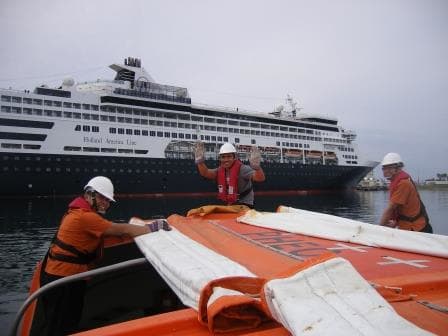
But SE swell is another story. It does not have to be an issue for the ship but it can be an issue for the port. And today it was. The long swell was running straight into the port and while going over the shallow area in front of the port, building up even more and then crashing into the dock walls. The captain sent a tender out to check on the Pilots reports and the crew reported in & concurred with the pilot, saying that things were not looking good. While alongside the tender rose and dropped constantly 3 feet and more and was not steady for a single moment. Imagine trying to step out of an elevator where the threshold is constantly going up and down by three feet. Not safe to do …………….and that we do not do. Hence the only decision that could be made was made, cancelling. Not nice for our guests, not nice for the shopkeepers, but safety comes first. The only good thing about sending the tender ashore was that it picked up lost luggage from Ft. Lauderdale. So we will have some happy campers on board.

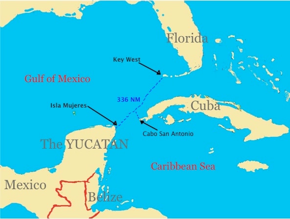
For Grand Cayman there is no plan B. If the downtown docks are too dangerous then it stops. And as long as Cuba is not open to us, we cannot dash over for an alternative port. Thus the only option is to stay at sea, sail a bit slower and enjoy a sea day onboard. The Cruise Director came up with an alternative program and I helped out with doing my HAL history lecture in the show lounge, which with careful planning, I managed to finish just before Happy Hour started in the Bars. By the time we sailed away the wind already started to breeze up. It might still have been from the wrong direction but it already followed the Trade wind patterns of increasing in strength during day light hours.

At sun rise it was a light Air, when we lowered the tender it was a gentle breeze, when we picked the tender up it was a moderate Breeze and by the time we sailed it was a Fresh Breeze (16+ knots) and the normal Trade Wind strength. If the direction had just been a little bit different……………………….  we would have made the call.

This wind business might need a little explanation. Although navigation is nowadays a highly technical operation we still keep the old traditions and names alive. Although this might come to an end as well eventually as the Beaufort Scale is less and less learned nowadays. Mr. Beaufort was an English gentlemen who in the 18th. Century invented a scale to classify wind strengths. It was his aim to ensure that when captains were talking to each other, when they boosted about surviving the same horrible storm, that they would at least be able to describe the correct storm force to each other.

So he came up with a scale of 12 steps and a description of each step in wind force, and sea state. 0 for no wind and flat calm seas and 12 for: such winds that no canvas can withstand. That corresponds with hurricane force winds. Nowadays we can measure winds way over wind force 12 (75 knots) so a wind force 16 would be possible but we do not do that. It stays with force 12………… as it is already bad enough. Apart from a wind meter you can see at the sea state what sort of wind is blowing.

beaufort

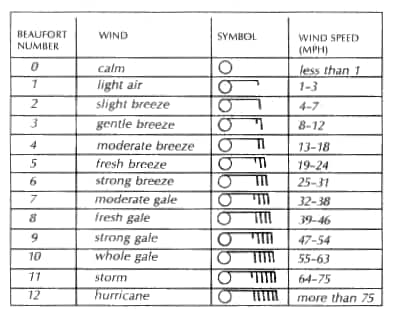
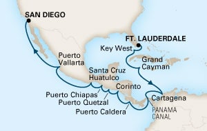
I still prefer to hear” it is blowing wind force 3” than to hear it is blowing 8 knots. 8 knots is a more precise measure but the force number indicates to me more what the wind is doing to the sea than anything else. Thus the remainder of today we are at sea and tomorrow we will be as well. Then we visit Cartagena for just over a half day. Staying longer is a problem as it endangers the timely arrival at the Panama Canal. And that is a no – no, because if we miss our slot, we might have to wait a long time for a next opening.

24 Oct. 2014; At Sea.

The route that we take today is a sort of Cruise ship highway. For all the ships that come and go to the Caribbean, the island of Cuba is very much in the way. And as the Cubans have not yet dug a Cuban Canal right through the middle all ships have to go around it. That means either on the West side (Cabo San Antonio) or at the East side (Cabo Maisi).  As we are coming from Key West and are going to Grand Cayman, we sail around Cuba via the West side.

cabo saThat means sailing all the way against the Gulf Stream which comes up along the East coast of Mexico and then moves into the Florida Straits. That is not good for making speed and thus the challenge is always to deal with the adverse current in such a way that it affects you as little as possible. Option one is to stay right under the Florida Keys as long as possible and then cut straight across, option 2 is to cut across and sail right above the coast of Cuba and option 3 is a combination of the two. It all depends where the axis of the Gulfstream is located. As mentioned in an earlier blog, we have charts that indicate where the Axis was located – recently – and hopefully it is still in the same position when you have to sail through the area. The axis can move considerably in a fairly short time and thus there is always a little bit of a gamble.

That brought us abeam of Cabo San Antonio around 7 am and from there we entered the Caribbean Sea. The current will remain against us, as it is supported here by the Trade Winds, which blow from East to West. Although today there was not much trade wind to be seen as it was almost wind still, courtesy of the frontal system that is now slowly pulling away. It will take a day or 2 before the trade winds are back to their normal strength.

The distance Key West to Gr. Cayman is such that it is too long to do it in one night and too short to really need to spend two days at sea. But if we would go full speed we would arrive around 11 pm in the evening and the night life in Georgetown is not such that it would make sense to do that. Thus we trundle along with a sedate speed so that we have a nice day at sea and then arrive at the decent time of 08.00 hrs. in the morning.

We will be at anchor there as the island has no docks yet. There are plans in development, varying from mooring buoys to a complete dock, but it is a careful process that is applied as whatever decision is being made, it affects the coral coast in one way or the other. Currently the ships are assigned to four anchorages and if there are more ships, then they stay on there engines and drift on location.

However no worries about that tomorrow.  We will be in on a Saturday and that means no other ships. Grand Cayman is mostly frequented by 7 day or 14 day cruise ships and they sail from Florida either on Saturday or on Sunday. Based on 2 days from Miami or Fort Lauderdale means that they can only make it there by Monday or Tuesday.  Thus we will have the whole place to ourselves and anchor at the most convenient spot.

That most convenient spot is anchorage number one as it has the best balance between good swinging room and a short tender distance.   All anchorages rely on the fact that the trade wind is blowing the ships away from the island and the anchor keeps them in place. As there is little wind at the moment it will be interesting to see if the little wind that there currently is will be enough to carry out a regular anchor maneuver.


23 Oct. 2014; Key West, Florida, USA.

In the dark of the early morning the Veendam arrived at the Key West pilot station after a breezy night at sea. But the weather did not throw a spanner in the wheel and on arrival at the dock there was hardly any wind. Wind is an issue in Key West, as the houses are barely built above sea level and there is no shelter anywhere in the port apart from those houses and three story apartment buildings. If I am not mistaken, the highest mountain in Key West is about 20 feet above sea level.  There are three docks in Key West, Mallory, Pier B and the Navy dock. All the ships want to dock at Mallory or Pier B, at least the company’s that is, but most captains prefer the Navy dock as it has much better bollards and more of them to hold the ship if a sudden squall comes through. The problem with the navy dock is that it is far away from town and has a long pier so they use those sjoek –sjoek trains there to get the people to the Gate.

Mallory is the most limited dock as far as bollards go, and if there is also a ship at Pier B then the ship at Mallory has to go forward as much as possible, to enable both ships to get their gangways out.  Today there was an Apartment of the Seas at the B pier and thus the Veendam had to move forward. That means that forward there are only spring lines that hold the ship. Some lines you could call breast lines (normally under 90o to the ship) but they were also sort of leading aft. Not nice if you expect a rainy day with the chance of an occasional wind burst. With the ship so far forward, the gangway is laid out in the Marshalling area of the ship (where we load the luggage and the provisions) and thus the guests have to walk through the crew area. Everybody finds that fascinating as you can peek into the crew mess rooms while walking by. We have guards along the route to stop the guests straying to where they should not go and we always have to get a few back on the right track. Some try to stray off on purpose but some just don’t pay attention and happily follow a crewmember who happens to walk in front of them………. and he or she also happens to be on the way to C deck and their Cabins.

The Captains have been lamenting about the lack of bollards along Mallory and B pier for a long time, but not much is happening to improve the situation. There has been for a few years a fierce debate going on about: more cruise ships, less cruise ships, bigger cruise ship, not bigger cruise ships.  It seems that the pro and con groups are more or less in balance and thus we wait for further developments. In the meantime the captains worry about being blown away from the pier during wind gusts. But I do like Key West, I greatly admire the groups of people there who woke up in 1968 and decided to remain in that year and who are very happy with that lifestyle. It must be a serene feeling to have your main concern of the day to make it to Mallory Square on time for the sunset.

I (finally) finished my training class for lifeboat attendants today with the much anticipated exam. I am very happy to announce that all but one passed and that one is getting a second chance. As I am now staying until Nov. 08th. for the 3 alarm system, I have the chance to give a 2nd training class and thus he can have another go at it.

Getting ready for Sunset in Key West from a 2012 photo

Getting ready for Sunset in Key West from a 2012 photo

Sunset at Mallory Square. Highlight of the day and on occasion a cruise ship blocks the view. To please again both parties (those who want to see the sunset and those who want to keep the tourists in port as long as possible) there is a permit system that allows a certain numbers of stays after sunset. Today there was no sunset as dark clouds were gathering at the horizon but also nobody had any reason to be upset with the Veendam as we sailed at 1600 hrs.

Tonight we will sail SW against the Gulf Stream and then tomorrow we come around the West Point of Cuba = Cabo San Antonio.  There is a large frontal system laying over the Caribe which is bringing all that rain to Key West but it is supposed to start moving away.

22 Oct. 2014; Fort Lauderdale, Florida, USA.

It was still dark when the ship arrived in Fort Lauderdale, courtesy of the fact that the distance is not that far from Port Canaveral and it is nearing winter and thus the days are getting shorter.  But it turned out to be a similar day as yesterday, overcast, hardly any wind and warm.  Today we embarked the remainder of our guests and that means that our voyage is now well and truly underway with a full house of eager cruisers. Not only North Americans, but also Australians, British, Germans and I heard a few far Eastern languages from Korea, Japan or China.

The ship has currently a visit from our Designated Person or D.P.  This is a compulsory function under the Safety Management System under which we operate; and as do all other shipping company’s as well.  Within this system a function was created to act as a bypass of the regular chain of command. Normally if something is wrong, in the area of Health, Environment and Safety or Security (HESS) then that is played up the chain of command until a solution is reached.  Now there is always a possibility that something that has been reported, is not reaching the level where it can be resolved.  This can be for various reasons, varying from just having forgotten about it, to not understanding the issue, or even unwillingness to give follow up.  In the unlikely event that this would be the case, the person onboard who does not get his/her situation followed up upon, has the option to contact the DP directly.

The DP then takes it up with the ship or within in the office, with the department that bears the responsibility for the area of concern reported and that department then HAS to follow up and report back to the DP. If that department or person would refuse to do so then the DP has the right and the obligation to march straight into the office of the CEO and Chairman to report and to seek a solution. Our Safety Management System is in the end the responsibility of the CEO who has signed off on the system. That document is called a Level 1 document and from there onwards the Safety Management System is sub divided into Level 2, Level 3, and Level 4 documents and procedures.  Level 1 is the cover letter where it all starts, the bottom line of the system, coming down from the top and hence the DP has to right to contact the person who signed off on at the top level of the system. Contacting the DP is not something that is being done lightly as you bypass the regular route of reporting. If it is done, then alarm bells go off well and truly as it indicates that somehow a reporting and correcting process is not working.  A well-organized company such as Holland America Line ensures that the system is working properly and that makes the life of a company D.P. not that exciting.

As far as I know, the DP of HAL has had in all the years that the system is in operation not really any calls that necessitated him to go directly to the top. Also he only deals with issues in relation to the safety of the ships and the company.  It has not much use to call him about your salary of your love life as that is not in his purview.

Part of the function is also to stay in contact with the fleet and that means a yearly visit. Either the DP or his designate (with 15 ships it is already impossible to do the visits in one year by one person) will go around the fleet to verify if the procedures for this “bypass” system are in place and if everything on the ship is running in the general accordance with the company’s Safety Management System.

Thus the Veendam now has its yearly visit and this time it is the DP himself. (It does not have to be a him it could also be a her).  Between now and Grand Cayman, he will nose around, do spot checks and will review the procedures to get a general impression of how well the System is applied onboard the ship.

Tomorrow we will be in Key West, docking at Mallory square from 0800 – 1600 hrs.  The weather looks a bit unsettled and it might be rather windy.

21 Oct. 2014; Port Canaveral, Florida, USA.

It was dry but overcast when the Veendam arrived at the pilot station of Cape Canaveral. The port is located just south of Cape Canaveral of NASA fame. As a matter of fact you can see the launching hangar with the naked eye just to the North. The pilot was even a bit earlier than scheduled, something we always like about pilots, and by 7 am. the ship was well and good lined up to enter the port. I assume that there was a sort of port originally created by Mother Nature, sometime in the grey mists of time, but if there was there is not much left of it. Everything has been re-sculpted and that is still going on, on a grand scale. The port hopes that eventually one of the Oasis Class ships, there are some under construction, will home port in Port Canaveral. Thus they are widening the entrance channel and a new passenger terminal is being built, located just off the harbor masters office.

The leading lights which the pilot uses to keep the ship in the middle of the channel is inside the little black circle that I have drawn in the photo

The leading lights which the pilot uses to keep the ship in the middle of the channel is inside the little black circle that I have drawn in the photo

The main fairway is straight in on a course of 270o and then ships move sideways to one of the inlets, dug off the main fairway. Currently all four cruise terminals are in the Northwest Corner and today all 4 were in use. Veendam on 1, Disney Wonder on 2, Norwegian Breakaway on 3, and the Europa on 4. (When counting from South, to West, to North) If all ships were full then there would have been 8,400 guests in port today. But for the Veendam that is already not true as we will get the balance of our guests onboard tomorrow in Fort Lauderdale. The funny thing to note when there are more cruise ships in port is that they do not all park in the same way.

The Veendam was nose in and the other three nose out alongside. You might think that how you dock basically depends on if the captain slept on his left side or right side the night before, but unfortunately that is not the logic behind it. It is all being dictated by the shore gangways. And if you want to use those, then you have to dock accordingly. Most shore gangways can only go up and down and that means that the ship has to park, often on the inch, with its access door lined up with the gangway.

In Port Canaveral these gangways are not jet walks and not regular gangways either but something of a mixture and for the Veendam to fit, it meant docking nose in. As predicted, the weather was overcast and not too warm, so we had perfect weather to lower the lifeboats for training. Due to our stay in Philadelphia – out of the water –it had been impossible for me to get lifeboats – into the water- with the result that all my training classes had to be put on hold until today.

Playing around with lifeboats is fun

Playing around with lifeboats is fun

Today was messing around with boats and it was as if we were all going on a school trip. So all day the lifeboat went up and down with small and very excited groups who were all inducted in the secrets of how to operate and drive a lifeboat. Not easy; lifeboat are designed to be full of people and when not they float very high on the water and the wind can blow them all over the place. Today there was no wind and that made it a little bit easier. We will leave tonight at 8 pm and then it is only a short dash to Fort Lauderdale. The entrance there is similar to Port Canaveral but once inside some of the docks are on the Inter coastal and that makes it a bit more complicated to get the ships lined up properly at their respective docks. And also the sailing course is different, can you do 270o in Port Canaveral, it is 267o in Ft Lauderdale.

The port of Cape Canaveral in the nautical chart.

The port of Cape Canaveral in the nautical chart.

20 Oct. 2014; At Sea.

During the night the winds subsided to almost nothing, much less than predicted and if it is better than the prediction, then I am all in favour.  Also the swells disappeared with the wind and now there is only a very low swell left coming in from the mid ocean. Looking at the direction I would say that this swell is a left over from our friend Hurricane Gonzales who after making life miserable in Bermuda is now getting people in the UK excited.

We are still on the way South, staying out of the Gulf Stream and the Captain is telling me, that it even looks like that we have a small counter current with us. At least we are going faster than the engines can move us forward so there must be something there.  We are roughly in the area of the North and South Carolina’s working our way down to Florida.

HAL's new cabin steward design.

HAL’s new cabin steward design.

We had some excitement today in the Housekeeping Department on board as the cabin stewards were issued new uniforms. Holland America tries to keep the image of those on board fresh and contemporary and started a new uniform project about 18 months ago. First the Lido stewards, then the dining room stewards and now the Cabin Stewards.  Also the uniforms of the Guest Relations Attendants were changed some time ago and that change included the Canaletto Manager.

Canaletto Managers uniform which is a regular crème suit with yellow tie.

Canaletto Managers uniform which is a regular crème suit with yellow tie.

I wonder if they will ever get around to the bridge uniforms. Always fancied myself in one of those Star Trek uniforms.

In some other ways, the uniforms have seen a reduction. Sailors wear more and more utility coveralls in the color brown instead of the blue uniform with the tally-wacker on the back. It makes sense as paint and grease show less on the coveralls and the coverall material lends itself better for cleaning out grease and paint than the blue uniform material.

With a sea day, going around everybody is catching up with paperwork and the planning for this Trans Canal cruise. I have been busy with plotting in all the drills, trainings and other stuff that I get myself involved in so that we get the most out of what is available. Due to our dry dock we could not finish the implementation of the 3 alarm system here and thus we will do it shortly after the Panama Canal. Then by the time we reach San Diego everybody will be very well drilled and settled into the new routine.

Tomorrow morning we should be docked at Port Canaveral by 08.00 hrs. and then stay until 20.00 hrs. The ship will get about 1300 tons of fuel onboard to make the coming voyage and then the day after in Fort Lauderdale, there will be heavy storing with provisions for the remainder of the voyage.

The weather forecast for tomorrow is not bad at all. Mainly overcast with temperatures just touching the 80’s. A good day for messing around with lifeboats.

19 Oct. 2014; At Sea.

Today we are sailing southwards towards Florida and we are about 40 miles off the coast of New Jersey. The reason that we are so far out is to avoid the Gulf Stream which lies currently fairly close to the coast. When you are in it, and it is against you, you can have an adverse current of anything between 1.5 and 4 knots and that slows the ship down considerably. Then to maintain the schedule, you have to go faster and that costs more fuel.

The darker the color, the stronger the current. Black indicates about 4 knots

The darker the color, the stronger the current. Black indicates about 4 knots

By sailing outside the Gulf Stream you solve that problem and you might even enjoy a bit of counter current; getting a free push in the back. It might cost a few miles extra in the distance to make but it only takes a quick calculation to decide what works the best. The NOAA and the Military publish charts with the latest location of the axis of the gulfstream but the charts give the situation that has already occurred as it take some time to correlate all the measurements taken into a decent chart. Thus looking for the edge of the Gulf Stream is a sort of quantified gamble. You have the best information available but nothing you can do about it if Mother Nature suddenly decides to shift the Gulf Stream a few miles one way or the other.

By tomorrow lunch time we should have a good idea of how good the plan worked. In the meantime the weather is very wobbly and the ship is quite lively even with the stabilizers working overtime. Hurricane Gonzales has moved away and only a few remnants of the swell it caused are still there, but its space has been very quickly taken up by a frontal system moving in from the shore. The Weather people have very nice descriptions for it but I just keep it simple. You should see a hurricane as a vast rotating vacuum cleaner that sucks everything away that is close enough to its vortex. That leaves a void that has to be filled somehow and thus somewhere a weather front will gather momentum and comes charging in. That has happened here was well and this morning we had 35 to 45 knots of winds blowing. A good gale in other words. Nearly full on the starboard side beam but with pumping water over you can keep the ship nicely up straight. However, the longer the wind blows the more grip it gets on the waves and the higher it will whip them up.

Since the late morning that has been happening and now the waves are on occasion too big to be fully handled by the stabilizers and that makes the ship move a bit. Stabilizers normally filter out 90% of a roll and that means that things would be very unpleasant if they would not be working. The forecast has been predicting about 30 knots but there is at least 10 knots more out there and thus there is also more swell, and movement…than anticipated . But it is not a heavy storm and the outside decks are open for all to enjoy and the relative wind on the deck is less due to the ship moving forward under an angle to the wind. Still being out there means that it is bracing. Most guests get back inside fairly quickly as they find it too bracing. Luckily there is enough to do inside the ship with presentations, shows and all sorts of gatherings.

I normally do not get the chance to nose around during a sea day but today I am in between all sorts of things and mainly cleaning up my administration before the head office gets going again tomorrow. So today I had a look at the Art Auctioneer who had her first show day of the cruise. I was impressed how busy it was. Either we have a lot of Art Connoisseurs on board or it was the free champagne that did it. Tomorrow is our 2nd sea day and, again if the predictions hold, by midnight the winds are supposed to ease off to about 20 knots and that means that the seas & swells will start to subside as well.

18 Oct 2014; Boston, USA.

Last evening we arrived in Boston and this morning the ship was ready to receive the guests.  For a cruise ship it is always peculiar when there is only crew onboard. First there is always the sigh of relief of having a day “without” guests; a day where you can do things that you cannot otherwise catch up with when there are guests onboard, but very quickly everybody starts to feel ill at ease as nobody can do the job they are here for: serving the guests. So this morning bright smiles on everybodies faces: we are back to being a cruise ship.

We actually start from Boston as the ship had been cruising in Canada before, but I was too late to copy it from the Hal website, so this was the nearest I could find.  Our first calls are Port Canaveral and then Fort Lauderdale where we pick up the remainder of our guests.

tc veendam

This cruise is officially labeled a Panama Canal reposition cruise as the ship will sail cruises to Hawaii in the winter. To get there we will create a three week cruise out of it, calling at some ports at the Atlantic side of the Canal and then hop along the West coast, calling at ports in Guatemala, Nicaragua, and Mexico. That will bring us on 08 November in San Diego from where the ship will start the cruise to Hawaii. There I will leave the ship and after a short spell in the office, hop onto the next DAM ship. I was supposed to have left from here on the 4th.  of October so this has turned into something of an extended stay. Not that I mind, the Veendam is a nice ship, I was captain of it between 2004 and 2008, and I have plenty of things to do to support the Captain and the Officers on board.

blog bye bye bostonBut first the ship has to get on the road and departure was set for 1600 hrs. That was going to be an interesting affair as behind us was docked the QM2.

Boston cruise terminal is located in a side bay of the river and to get out you have to back the ship, (go astern) back to the river.  Plenty of room to do it but once passed the QM2 there was a container vessel docked at the other side and thus the had the Veendam to make a small swivel movement. First hugging the far side of the channel and once clear of the QM2, hugging the near/dock side to give the container ship with its overhanging cranes a good clearance.

One can just see the QM2 sticking out from behind the Veendam and in the distance the MSC Stella at the container terminal

You can just see the QM2 sticking out from behind the Veendam and in the distance the MSC Stella at the container terminal

Maneuvering with a ship is all about having a plan B. In other words having something up your sleeve in case the plan A that you had in mind does not work out for whatever reason. In the early afternoon it was blowing 20 knots and gusting higher and the thrusters can handle about 26 knots if the ship is sitting still in the water. As soon as it moves, the flow/thrust gets diluted by the ships speed and then the effective output is less.  If plan B consists of gently drifting back to the dock in case of a squall or wind burst then that is a good option. If there is a ship at that berth then it is not. as even “gentle drifting” tends to create damage.

Thus Plan B today was to have a tugboat on standby.  Captain Chris Norman had looked at the weather when it came close to the dead line of ordering a tug, and as at that moment the wind was still too strong, the decision was simple to make. As is often the case, then just before departure the wind died away, and then comes the thought, I could have saved that money………………. But you don’t know and thus better safe than sorry.

Clear of the Queen Mary 2

Clear of the Queen Mary 2

By 1530 all the guests were on board and they all had attended the Emergency Drill so the good ship Veendam was cleared and ready to sail south.  We sailed astern out of the slip and exchanged greetings with the QM2. I was a bit amazed at her whistle. The law stipulates that a certain size ship has to have a whistle with a pitch that decreases in tone height, the larger that ship gets. Well I am very happy to say that although the QM2 is 2.5 times the size of the Veendam, her hoot & toot was not any more expressive than the Veendam’s.

Over Boston dark clouds were gathering and it smelled distinctively wet in the air, it looked like we were gone just in time.

Tomorrow and the day after we are at sea, sailing along the East Coast of the USA, and then on the 21st. we will visit Port Canaveral as out first port of call. The weather forecast is a bit unsettled as our Hurricane friend Gonzalez still has some influence on the weather so it might be overcast tomorrow or it might start to break up already. We will then also find out if the swells created by the hurricane have reduced themselves according to the predictions of yesterday. We should have about 6 feet and makes for a very smooth ride.

17 Oct. 2014; At Sea.

Today is our sea day before we arrive in Boston to get back in the cruise schedule. As the  hurricane of the day is creating havoc about 700 miles away, we have no issues with the wind but the swell is coming all the way to us; and the ship is quite lively even with our stabilizers working full time. By tomorrow evening that swell should start to subside and if the predictions turn out to be correct then the guests will have a smooth ride down to Port Canaveral. Of course it is not good for a cruise ship sailing without guests, it upsets the accountants and eventually the shareholders, but for us dealing with safety, it is quite handy.

We can do drills to our hearts content without having to worry that we reduce the guest’s satisfaction. So today I facilitated a fire drill which came into the guest areas. Normally the fire crews might have to go through guest area’s to get to the location but having (stage) smoke billowing through the corridors is another matter of course. But now we had the chance, so we took it. Switch the A.C. and pump out enough smoke so that visibility is reduced to less than 5 inches. (We have a very good smoke machine!!!)

The philosophy between shore side firefighting and shipside is completely different. If needed shore side they can keep everybody at a safe distance and then control the fire. We do not have a safe distance; we are on the ship so we have to go in at all times, to stop it from being a local fire, to shipside fire. While the shore side can call in much more resources than we do and have much more extensive equipment available we have the advantage that we are always “on top” of the fire, or under it if it is on the higher decks.

Also we know exactly what is in which locker so we can plan better than shore side, who seldom knows what they might come across when they attend a fire at a house or factory. They have to tread very carefully as they never know if there are gas bottles or other explosive devices located inside. Very scary and very dangerous. The owner is not always there, nor does an owner always realize that his barbeque, or drums with chemicals, can be the cause of instant death of a firefighter, and might just forget to mention it. We know where everything is, it is all on the fire-fighting plans and thus we can attack much more specifically. It is standard in the ships fire fighting business that you have to get to the source of the fire within 10 minutes otherwise it is getting difficult to control it. You might still be able to do it but a larger area will be affected and it will be harder to extinguish it.

The teams, we have four of them, two deck and two engine, are trained in rapid dressing up and should be fully dressed up with breathing apparatus (SCBA) operational in about 5 minutes. That gives them then 3 minutes to get to the staging area (from where the attack starts) and then they should be on location, safely behind two hoses within the next 2 minutes. From then on it depends on the location of the fire, how extensive it is, and if there are casualties inside that have to be evacuated.

The bridge is guiding the process but the attack is being orchestrated by a First Officer, who is called the OSC – On Scene Commander – who sets up “The Box”. This means that as quickly as possible the area concerned is surrounded – boxed in – by the fire teams. Then one team attacks and a second team is ready to help. Sometimes they both go in, sometimes one team can do it if it is a smaller problem. Then there is a whole slew of supports troops. Medical with a stretcher team, Security with an evacuation team, Hose handlers, SCBA refill team, 2 man who carry the thermal imaging camera’s, a Passenger Assist Team that evacuates the nearest guest cabins, a Passenger Notification Team who are ready to answer any questions from the guests, etc. etc.

The initial evolution gets about 80 crew on the move and if things are not settled quickly that goes up to about 200, if the captain starts considering getting the guests to the lifeboat stations or completely to the other side of the ship. So we had our fun this morning. The only one who might have been a bit unhappy about it all could have been the Exe. Housekeeper, because when you mess around with charged fire hoses, you get water everywhere. But we have those beautiful industrial size vacuum machines that can take care of it very quickly………………….. so why not use them once in a while?

Tomorrow life will return to normal and we will start our Trans canal.  We embark the first group of guests and then the rest is coming in Fort Lauderdale for a cruise which will end in Sand Diego on the 8th. of November. It will be interesting to see how far they have progressed with the Panama Canal. They had some set backs but I think they are rolling well forward now.

16 Oct. 2014: At Sea.

Well dry dock work was completed today so the good ship Veendam left the dock and sailed down the Delaware River back to sea. Yesterday I blogged about the Holland America cargo ships calling at Philadelphia on a regular basis but I did not mention the passenger ships. Well there weren’t any.  In the days that HAL ran the Trans-Atlantic service, calling at Philadelphia meant a longer sailing time on the ocean and then another 80 miles on the river with slow speed. Landing passengers in NY was thus faster and with the rail road connections, the number of people going in the direction of Philadelphia could easily be accommodated by train.  Thus it remained a cargo only port.  It might be possible that the passenger ships have called there in the past occasionally but I have not found any dates yet.

The reason I know the dates mentioned yesterday is that I am busy with trying to record every voyage, each HAL ship has ever made. Starting in 1872 until the present day.  I am now up to just over 8000 entries and more or less complete until 1922. That means that I have another 90 years to go.  The information about all the voyages can be found in the HAL archives in Rotterdam. Most offices, both in Rotterdam and New York, kept what they called Movement Books in which they noted the ports of call during each voyage, the number of passengers on board, the value of the cargo and the use of coal and or fuel oil. That way I also find the names of the captains as it is one of the ways that they are recorded.  The challenge is, and it is a real challenge, is that the archives are not complete.  The company was not always focused on keeping material for their historical records and then there was the great flood of 1953. The archives at that time were stored in the basement which is not a good place in a country that can flood easily. During the Feb storm of 1953 the water was pushed so high up the Nieuwe Waterweg to Rotterdam that it came above the dock edge and washed into the cellars of the Head Office. A lot of material was lost.

It means for me and other historians it is a puzzle to find out details of the company’s past.  Fascinating but time consuming. Thus during each vacation period, I spend at least a day in the archives and photograph the books that survived. Then, when at sea, I spend one hour each day transcribing the voyage dates from the books. It is a slow process but eventually everybody will be able to see the complete records on the blog site. Both of the captains and the voyages of each ship.

Western shore with the Philadelphia airport in the distance

Western shore with the Philadelphia airport in the distance

With slow speed going down the river means that it takes approx. 6 hours from sea buoy to the dock and vice versa. The Delaware River is, at least at this stretch not very scenic and we mainly sail past industrial complexes. The river remains fairly wide until past Philadelphia upstream and anything that might be scenic is not so easy to see.

It is wide but not deep. The central fairway has to be dredged regularly to keep it open to deep drafted ships. Necessary as deep laden tankers travel all the way up to Philadelphia.

Same view but now on the Radar. The airport are the two beams near the top. Light blue indicates shallow water, black the dredged fairway.

Same view but now on the Radar. The airport are the two beams near the top. Light blue indicates shallow water, black the dredged fairway.

What was of interest were two things.  One, just past Wilmington, they are building / creating / constructing a mountain and when just passed by that location, there is a bridge, high enough to let a  ship of the Veendam size pass under.

Delaware Memorial Bridges

Delaware Memorial Bridges

The mountain is of course the local garbage dump and what was special about this one was that it was nicely covered over. While we saw the garbage trucks rolling in and out, behind them rolled trucks with soil covering the slopes of the mountain straight away. I did not see a recycling plant there for separation but maybe that is at another location.

Up and down the river, the pilots conn the ships by keeping it in the ranges. Using green leading lights that are kept in line – Green above Green –

And the same bridges but now in the chart

And the same bridges but now in the chart

When in perfect alignment the ship is exactly in the middle of the fairway. A ship that comes the other way is doing the same thing and then the pilots talk to each other to make passing arrangements. Most of the traffic on the river is with barges and the tugboat skippers that push or pull the barges are tuned into this as well.

As these barges can come from all over the States a rich variation in accents can be heard over the VHF; and sometimes you wonder if they can all understand each other.  Some accents can be quite heavy and those from Alabama do talk slightly different than those from New Jersey.

We will now head for Boston for a timely arrival so we can get back into the cruise schedule. Our next cruise is the Panama Canal, ending in San Diego, and I will be on board as dry-dock also curtailed my activities.  The weather at the moment is not that great out there so we will have a bit of a wobbly ride.

« Older posts Newer posts »