The more you sail on a route, the easier it is to predict what you can expect in a certain area. At the same time you question yourself more if what you expect does not happen. Before we left Puerto Caldera the bridge team had discussed the weather that was to be expected during the next stretch of the cruise while sailing towards Huatalco. We were going to pass two areas with strong winds. The first one, while sailing past Lake Nicaragua, the 2nd one, while sailing through the Gulfo de Tehantepec. In both areas’ the winds are caused by gaps in the mountain range that divides the Caribbean Sea from the Pacific Ocean influence area. If you know the average wind and direction in the Caribbean Basin, then you can quite accurately figure out what the wind will be on the Pacific side. Not within one or two knots but definitely in the 5 to 10 knots margin. That helps with the planning and we can in advance select the tanks that we can fill with sea water to keep the ship upright from being pushed over by the wind. Continue reading
Category: CaptAlExport (page 93 of 203)
We arrive here very early due to the tight schedule between Puerto Caldera and Huatalco and that means a pilot station ETA of 05.00. As the port itself starts working about an hour later, when it gets day light, we always have a challenge to contact Port Control to confirm our arrival time. We already have the confirmation from the agent that all has been arranged but you have to make sure that pilot and port control also gets the confirmation from our side. This means that the officers on the bridge start calling on the VHF about an hour before arrival to see if anybody is awake. This time is was about 20 minutes before 05.00 when somebody suddenly woke up and in rapid Spanish started to create some excitement on the radio waves. My Spanish is not that good but I could easily follow the gist of the conversation; being that this gentleman was rather shocked to suddenly to see the Statendam looming over the breakwater. I had simply parked the Statendam on the pilot station and that had the desired result. If that does not help, then there is always the option to start blowing the whistle. Continue reading
One thing I have not mentioned very much is one of the traditions we have in the Panama Canal. And that is serving Panama Rolls during the morning. We have them around the ship for the guests, we have them on the bridge and most important we have them on the mooring stations. For us that is important as it keeps the Panama Canal crew happy. When going through the locks we get 19 Panama Canal crew on board, 12 forward and 7 aft for handling the wires of the locomotives. We have more of them on the bow due to the fact that with the flare of the bow, the area that needs to be covered is larger and thus more men needed to handle the wires at the same time. On the stern, the aft mooring station is more compact as it is the blunt bit of the ship and thus 7crew suffice. Each group has a bo’sun who is in contact with the pilot on the bridge, on the same VHF channel as the locomotives. As soon as the locomotives have been connected they are on standby, waiting for them to be disconnected again. To keep them quiet and happy in the interim, we fill them up with Panama Rolls (http://recipes.wikia.com/wiki/Panama_Cinnamon_Rolls) and Orange juice. They get through a lot of that stuff as they tend to stack up for home as well. I have attached the recipe, although on the ship we do not always include cinnamon. Continue reading
It was extremely busy at the West Anchorage of Cristobal with a large number of ships waiting for a canal transit. On the East side were a number of containerships waiting to dock at Manzanillo port, just east of the Canal. They cannot anchor because it too deep there and that creates a problem. They drift all over place and of course also onto our course line. As explained in my last Canal blog, they are not regulated by the Panama Canal as the East area is out of their jurisdiction. So we had to wriggle our way through the accumulated drifters to get to the breakwaters for a 05.00 arrival. We work that sort of thing into our voyage plan and thus we had extra time on our hands for that wriggling and that meant that the bridge sailed through the breakwaters at 05.00.14 and I could not make it more precise. Continue reading
After leaving Aruba we sailed west, keeping a large number of those waiting tankers on our portside. They were drifting with about 1.5 miles in the hour to the west due to the current that flows under Aruba. We had that current to our advantage for a few hours as well and a free push in the back is always appreciated. We lost that current around 9 pm. and from then on we just had our ships speed with a following wind. We will keep that following wind until a few hours before we reach Cristobal as the weather chart is indicating that it will be wind still in the Panama area.
The moment you talk about Aruba, the first thing a sailor asks is “how is the wind” because it can blow there…. considerably. Even with the port located on the south side of the island it is still a windy happening as the island is basically flat. There is one real hill, called the Hooiberg, or “Hay Mountain” rising up from the flat land but it does not offer any protection to the ships entering the port. Thus the wind is of great interest to any ship’s captain coming in and certainly to captains coming in with floating apartment buildings that seemed to have been constructed to catch even the slightest breeze and turn it into a challenge. So I keep a close eye on the expected wind in the local forecast and when we arrive we check with port control whether the “Forecast” is indeed also happening in the port. Continue reading
By the time I received my wake up call, the mountains of Haiti were clearly visible on our portside. The ship had just sailed by Cape Tiburon, that is more or less the most South western point of Haiti, at least the one with the most recognizable name. The weather forecast was not indicating any surprises apart from a large wave field in the late afternoon and early evening. That wave field was slowly moving to the West and by the time that we went through it, we skirted the edge and not the centre area and that caused a bit of movement but nothing to be concerned about. Continue reading
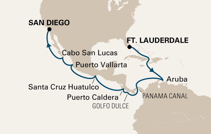
Our final westbound transcanal cruise for this year.
By midnight we had left the Florida Strait and sailed into the Old Bahama Channel. Because the strong, cold front wind was pushing the Gulf Stream towards the coast of Florida, it squeezed the width of the Gulf Stream a bit as well. That caused a sort of build up against the Cuba coast and as the water has to go somewhere; it flowed quite strongly into Old Bahama Channel. That gave us at times about 2 knots of current with us and that helped gain me back some of the time lost yesterday, waiting for the C.Eclipse to sail. The average speed to make to Aruba was 17.9 knots and we topped the 20 knots on occasion and that helped balance the books a little bit. Continue reading
Apologies for the late posting, but the satelite guru’s in Miami have had us switch to different satelite reception and our big funnel was in the way for most of the day while sailing close to the coast of Cuba . Changing course was not possible as we are not allowed to go to Cuba yet.
It was extremely breezy when I came on the bridge at 04.30 so much that I decided to call out a tugboat, as a safety precaution, especially as we had to back up the Intracoastal, past the Celebrity Eclipse and past a bunker barge. Bumping into another ship is never a good idea but bumping into a fuel barge is an even worse idea, thus a tugboat for peace of mind. All the ships were nicely on time and so the whole parade could enter as planned by the harbor master. Then 30 minutes before the pilot station, the wind suddenly moved to a North Westerly direction and as it was now blowing overland it lost most of its ferocity. Which meant it could have easily done it without a tugboat. But we cannot predict what the weather is doing and thus we get it wrong sometimes. (If I could predict the weather correctly, then I would be working for CNN and make real good money) Continue reading
The cold front did come down faster than expected and instead of having a nearly wind free day while sailing towards Ft. Lauderdale, it blew 25 knots from the North East and it kept doing so for the remainder of the day. And what happens when it blows from that direction; it changes the current in the Old Bahama Channel, from one that goes with us, to one that goes against us. So instead of getting a free push of .05 to 0.75 in the back, we got it against us now, which makes a difference of 1.5 knots. Over 24 hours that is a nice bit of fuel that could have been saved. Continue reading
Captain Albert

© 2026 – Captain Albert's Website and Blog –
Theme by Anders Noren — Up ↑