Today we were sailing along the coast of Namibia towards Luanda in Angola. Around 7 pm this evening we passed the border between the two countries, although today there was very little to see of the coast. We are staying about 12 miles out and cloud formations over the land make it not so easy to see the low lying coast land. We are at least 12 miles out, to stay out of any form of territorial waters, and that might need a little bit of explanation.
The world Seas and Oceans have been parceled up and allocated to the surrounding countries to ensure that everybody knows what belongs to whom. The system is not completely fail safe and we read regularly in the newspapers about countries quarreling over miniscule islands that are hardly big enough to pitch a tent on. However if the island is miniscule, the territorial sea around it makes it interesting to get even very small bumps of land under control.
Who has the right to own what is governed by UNCLOS, the United Nations Convention on the Law of the Sea. Every country who has signed this treaty is bound by the boundaries it sets. Which means that you can only bicker about what land (Island) is yours in order to extend the area of sea under your control.
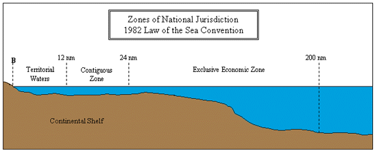
There are several boundaries, called Maritime Zones.
1. Where the land ends. This is the base line and that is normally the low water line of a state. Everything inland of that line are the inland waters of a country.
Example: for deep sea ships here inland water way rules apply.
2. Then the next line can be 1 kilometer away or 3 miles and defines where certain Local and National Laws are still applicable.
Example: Florida has a sales tax on drinks. It applies also to cruise ships when they are within the 3 mile zone of the Florida Coast.
3. The next line is the 12 mile zone line. This is called the territorial sea. Here a country can apply all its National laws.
Example: A country would have the full right to erect a windmill park, without needing permission from anybody else.
A ship has the right “of innocent passage” through this area, which means that the local state cannot stop the vessel unless it is violating safety or pollution rules.
4. The next line is the 24 mile zone line. This is called the contiguous zone. The adjacent country has the right to exercise supervision. Also here the law guarantees freedom of travel.
Example: if two fishermen would be fighting over a catch in this zone, then the country attached to this zone could dispatch a fisheries inspection vessel to see what it was all about.
5. The final zone line is the EEZ. The Exclusive Economic Zone. Here the adjacent state has the exclusive right to “explore and exploit, conserve and manage natural resources”. If it allows an oil rig in this area, then it also has jurisdiction over that oil rig.
6. Beyond the EEZ is the “High Seas” which is in principle not governed by anybody.
Of course some countries are closer to each other than 12 miles, (think about the USA and Cuba) and then local agreements are made about where the dotted lines run.
 As a ship we can sail basically anywhere outside the 3 mile zone without having to deal with the Country along which coast we sail. However every country has the right to apply all sorts of law up to the 12 mile zone. As it is impossible for us to know what every country is up to, we tend to stay away for this distance to avoid any hassle. Sometimes we can’t and then we have to go closer.
The quarreling that we read about in the newspapers is caused by point 4 and 5. If you can extend your zones a little bit by claiming a reef or something as being part of your country then you can extend you EEZ and you might get control over a large oilfield that you could then explore and exploit.
Tomorrow will be another sea day and then we will call at Luanda in Angola for one day. The outside temperatures keep climbing and are supposed to reach the 70oF tomorrow, up from the mix sixties of today. However it still felt chilly today courtesy of a fresh breeze blowing from the south and bringing cold air from the Antarctic.

November 22, 2014 at 4:31 pm
You certainly have to know a lot of things I have never thought of, very interesting as usual all
Those zones in the Sea etc: amazing Knowledge you have, I am very impressed,
Thank you again for taking me into new territory once more
Best wishes Robina Herrington UK
November 22, 2014 at 5:05 pm
Very interesting and concise presentation of confusing territorial rules. Thank you Captain Albert…..Ruud
November 24, 2014 at 10:00 am
I’ve said this before, but I sure hope you will be one of the presenters/featured (guest??) speakers on a grand or world voyage. If you do it, it should be advertised with the initial offering of the particular cruise… I think it would be good for sales. Or maybe you could be the feature of a shorter cruise where you are the “draw” (main attraction). I realize this is expensive… not sure how to get around this for HAL. Maybe combine it with a HAL personnel training assignment….
November 25, 2014 at 1:12 am
Thank you for reading my blog
The only thing I can say at the moment, is watch this space……..
Capt. Albert