Tropical Storm Sean is still active in the North Atlantic Ocean but moving very slowly and I do not expect that it will have much effect on the weather around Florida. It will be a breezy day but that is nothing to worry about. For the time being, the weather is great, we are sailing between the Bahamas and Cuba and the numerous islands, reefs and keys are really doing a good job with taking the momentum out of the windy weather coming from the North. The only thing that I do not like is that the wind has already turned to the NNW. And that means it is a head wind and I am losing the free knot of pushing current that I had hoped for. The area North of Cuba normally has easterly winds, part of the flow generated by the trade wind system. If that flow is not interrupted it nicely starts to push the water to the North West and that gives the ship a knot to 1.5 knots of extra speed in the back. As soon as that wind stops, the current diminishes and if the wind then turns to the West or North West, it falls away completely. The ship loses that free speed and instead has to start heading into the wind. This was the case today and now I was not saving fuel but spending it, as the ship now had to push harder while going against the wind. Hopefully I will get some extra free speed tonight when we enter the Straits of Florida, although with the NNW wind blowing there, the Gulf Stream might not be running that fast as with following winds. Continue reading
Page 153 of 244
We had everybody back on time and thus we could sail as scheduled from the pier. As we were departing in the middle of the afternoon we could see the port at its busiest. Containerships were coming in and going out, or shifting berth. The latter was done by a Hapag Lloyd container ship and meant that she was moving about 300 feet forward along the dock. For that reason a tugboat was used to pull the stern off the dock while the bow came off with the bow thruster, all lines were let go and so I thought that she was going to leave at the same time as we did. That might mean delay; not good for us. However the pilot confirmed that the ship was only shifting. I have done that in the past as well but we just pulled the ship along by moving the lines along the dock. That reduces cost as you only have to pay for linemen. Here in Cartagena they are afraid that you will damage their dock fenders and thus they require you to have a pilot on board and come completely off the dock. Without a stern thruster you then need a tugboat and that makes it a very expensive 300 feet. On the way out we saw even more discolored water from the rain fall of the night before and I really wonder if one day that whole bay is not going to silt up. There is some tide in the bay but the current that sustains it is not really strong enough to churn the mud away and carry it to open sea. So there is reason for concern. I will have to ask the pilot next time if they are dredging here on a regular basis, as I did not see any dredger in or around the whole bay area.
From the Panama Canal exit at Cristobal to Cartagena Pilot station is almost one straight course with just a small knick north of the San Blas islands. As soon as you are 30 miles from the Panama Canal you do not see much traffic anymore as there are no significant ports in the area except Cartagena and although a busy port it does not generate that much Panama Canal bound traffic. Sometimes you come across a cruise ship on a similar run as we are doing but that is about as much excitement as you will get. The sea area here is called the Columbian Basin and is basically the extreme South West part of the Caribbean Sea. The moment you come away from the coast the depth increases dramatically, down to 4000 to 5000 feet, only to rise sharply again when nearing the Columbian Coast. Then, when it approaches Cartagena Bay it becomes extremely shallow. So much that it makes me wonder sometimes. The draft of the Statendam is not that much that it becomes a problem but it must hamper the ports capabilities with not being able to have the big container ships or big tankers coming in fully laden. Also the width of the entrance channel is not that great and again it must put a limit on what can go in and out of the port. Still, we knew that we fitted in with our draft and that was all that counted. Continue reading
No changes were received to the schedule that I was originally given and thus the good ship Statendam started to raise the anchor at 0300 in the morning. It was indeed a very muddy anchorage and it took us over 30 minutes to raise the 400 feet of chain and anchor that we had paid out. Normally we do that within 10 minutes. Then we slowly steamed to our designated 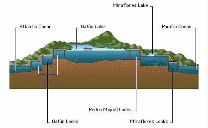
Panama overview. courtesy: unknown source on the internet.
waiting area which was in the middle of the normal Canal anchorage. A lot of cargo ships crews suddenly and un-expectedly had a fully lit up cruise ship steaming by. Always a nice thing to liven up your boring anchor watch. The pilot hopped on board shortly after and then it was time to locate the Panama Canal Clearing Agent to get the paperwork done that would allow us to enter the Canal. As was the same last time, he was stuck on another ship and thus we steamed slowly towards the Canal while awaiting him. He finally showed up on time and we just got the final stamp placed before the whole circus started with 2 more pilots coming and the Panama Canal crew for the first locks. In the meantime we sailed under the Bridge of the America’s in the dark but as the bridge and the whole port of Balboa next to it was lit up as a Christmas tree, it provided a very scenic panorama. With this early start we had the first locks just before sun rise and the next locks before it was getting real-Panama-hot. The sail through, through the lake, you can then see from the leisure of your chair. Either on the balcony or from a public room or the Lower Promenade deck where we have the steamer chairs. Continue reading
You will notice that I have uploaded a bit later than is normal for my daily addition to the blog. Normally I write this during breakfast but as I spent most of the night and day on the bridge today; I could only compose the yesterday’s blog during dinner time this time. Yesterday the 5th. was for me a sort of important day as well, although I had almost forgotten it. Same as I tend to do with my birthday, my wife tends to remind me. But yesterday I was 30 years with the company and I celebrated that appropriately with the cup of green tea. I do not drink during sailing, so there was little use to pull open a bottle of wine. I will postpone that until I get home. So now I am having to make up my mind if I want to do another 10 years with HAL, to make my forty years, or two years less, which will make it 40 years at sea. I did my cadetship with Incotrans (the old HAL cargo side) so it does not count towards my HAL years. We will see. God giving and good health might make me decide to do the other 10 years but Big Boss will have a big say in that as well of course. Continue reading
After leaving Puerto Quetzal we sailed on a straight south easterly course towards the most south western point of Panama. As can be seen on an atlas, the whole area of Middle America is very crooked and that meant that we were sometimes close to land and sometimes quite far away. Around 0400 we were passing the border between Guatemala and El Salvador, followed around 0630 by El Salvador and Nicaragua and then by 0930 Nicaragua and Costa Rica. Due to “the bend” in the land Costa Rica has a large coast line and it will take us the remainder of the day to pass by there. No wonder that the coast line is mentioned in the name of the country; Rich Coast. By noon time we were abeam of Golfo de Nicoya which gives access to Puerto Caldera where we call at on the way back instead of Puerto Quetzal. Our Westbound cruise is slightly different to the eastbound cruise to give guests who are doing a “Back to Back” cruise something new to see. This cruise we have about 20 of them on board. Some of them because they do not want to fly, some of them because they simply like to be at sea as much as possible and some of them to clock up a few extra days to get them over the next Mariner level. Continue reading
At 4 am. my wakeup call came and 15 minutes later I was on the bridge seeing that all was well in the world. No wind, low swell, all navigation lights (buoys and leading lights) were working and visible for over 10 miles away. It was a chilly morning for local standards with a temperature somewhere in the low seventies. When the pilot came on board he complained about it. It did not help him either that he came on the bridge of the Statendam which is chilly at all times, as that is what all the electronics like. This time we had a very chatty pilot who kept talking about having been to Holland, England and all over the place during the time he was in the navy. It made it somewhat harder for me to concentrate on bringing the ship in but at least he did not interfere with the process itself. Continue reading
It is always nice when a theory works out in reality. By adding my “Tehuantepec off shore correction” to the local weather forecast, we did indeed get the wind that we were expecting. About 40 knots of wind was blowing for a short while, mostly in the late evening. To be on the safe side we had the ship prepared for much more wind, as the weather forecast for the tehuantepec area can be notoriously wrong but in this case it was more or less correct, as long as we applied the offshore correction. Continue reading
It is only because of to the scheduling but I like the fact that we arrive at this port at a decent time; just after breakfast. No reason to get up early and hoping that the pilot has not overslept; no we can first get the early morning work out of the way and then approach the port and be docked just before coffee time. It cannot be more pleasant. It also means that the pilot is up and about as even if he overslept, he would still be around woken up by the sun and the whole port community, who needs him to get the ship in. Pilotage is compulsory here, as is in most other places, and I need the man because he communicates with the linemen so the ropes go on those bollards that we want. We have sometimes great challenges as in some ports the linesmen put the mooring rope on the nearest bollard so they do not have to walk any further. The nearest bollard is not always the best one, as we like the ropes to run long, so they can take the strain of the ships weight in the best way. Here in Mexico the pilot directs the linesmen and that is really handy. I wish it would be the same in the rest of the world. So by the time we arrived, the pilot was bobbing up and down in his pilot boat and 45 minutes later we were safely docked at the cruise ship pier. Continue reading
Another peaceful day at sea, while we cover the 700 miles between Puerto Vallarta and Huatalco de Santa Cruz. For most of the day we can see land on the portside as we are sailing roughly between 10 and 14 miles from shore. The only thing is that the weather has been so nice in the last few days without any wind, and that creates very hazy skies and thus the shore line is not very clear. Only the outline of the inland mountain ranges shows up in a sort of darkish blue. We passed Acapulco around 1900 hrs. today and even its lights were only just visible. Still we cannot complain and if we can keep this weather for a while longer than I will take the haziness in my stride. Because it was so wind still, it was fairly windy on deck. Now the real wind did not blow, everybody could feel the wind created by the ship. As we were travelling with a speed of 17 knots, it meant that we had a wind force 5 blowing over the decks and that keep the outside temperatures quite pleasant. Noon temperatures rose to 29oC or 84oF and that is nice and cool compared to tomorrow when we are docked in the sheltered bay of Huatalco when it all will go up to the low 90’s. Continue reading
Captain Albert

© 2026 – Captain Albert's Website and Blog –
Theme by Anders Noren — Up ↑