It is a distance of 879 nautical miles (0r 1011 land miles or 1628 km) to Amador from Puerto Quetzal. That makes a timely departure necessary and then all the way we have to keep up the speed to ensure that we arrive on time for the evening tours in Panama. On the way we have the current against for the last part of the voyage, plus we can have the wind when we sail of Nicaragua. When you look at the map you can see that Nicaragua is located in this recessed section of Middle America. We are sailing on a straight course and that means that we have a large open water area to the port of us until we reach Costa Rica. Nicaragua is a low lying country with a large lake in the middle so Caribbean Trade winds can easily blow through to the other side. It is never as bad as in Tehantepec where the gap in the mountains is much smaller, but still it can be very windy here. The problem is you never know from which side it will be blowing. This time we were lucky, the wind was with us and that might have even helped with the speed. But at least it did not slow us down. It is very peculiar to see this phenomenon, at 11.55 it is blowing a good wind force 7 and then 10 minutes later it is wind still when the ship has sailed passed the windy area. It looks indeed as if somebody just switched the wind off. It caught my fourth officer completely off guard. He is preparing my daily voice from the bridge and takes great pride in having the figures exactly right. Thus it was a bit startling for him when he gave me the paper, and then to turn around and see that wind force 7 had just changed in a wind force 0. Continue reading
Category: Captain’s Log (page 37 of 128)
It was an early morning and it looked like it that we were the only ones awake in the port. As a matter of fact we probably were, as we could not get any answer out of Port Control. So we called, yelled and screamed for over an hour on the various VHF channels but deadly silence remained. The only thing that really helps then is to park the ship squarely in front of the entrance so that nobody can get in or out. That always makes a lot of people nervous and nine out of ten times it results in very quick action from the other side. And so it was this time; with the Statendams well lit “bulk of superstructure” suddenly looming over the breakwater, the VHF spluttered into life and port control had an AHA Erlebnis as the Germans say. A lot of incomprehensible Spanish spouted forth and the pilot boat came racing out of the port. By the time a highly flustered pilot had made it to the bridge, I was already on the way in. Still the whole affair cost me half an hour, so I was very happy with myself that I had set the arrival time a bit on the early side. We have to be docked in Puerto Quetzal by 05.50 to get the flight tours off at 06.00 hrs. We just managed that. The gangway was pushed ashore by 05.51 and at 0600 the tours were streaming off the ship. I was not a happy camper of course with this delay and let the whole wide world know about it. But Puerto Quetzal is a cargo port and they have a hard time understanding the clockwork operation of a cruise ship. And what Port Control does during the night is everybody’s guess. Continue reading
The Golfo the Tehuantepec indeed behaved itself and we observed no more than 20 knots of wind, a nice and quiet day for that area. By the time were past it, the wind dropped down to nearly zero and we knew that the weather forecast had been right. Our pilot was on time and he was a very proud man, showing off his new pilot boat. It was even equipped with flashing lights so from a distance it looked like it as if it was an American police car, half submerged, going through the water. Sailing into Puerto Chiapas is always an event, it looks so simple; just keep the ship in the middle between the breakwaters and you are in good shape. But things are not that easy here. There is always a little bit of swell which makes it difficult for the Quartermaster to steer as it pushes the stern off the intended course. That means that you have to give rudder orders and anticipate where the ship will swing to. It is MUCH easier when there is a lot of swell, then you simply cancel the port as the swell reduces the depth at the entrance too much. Continue reading
There was no sign of any earthquake damage when we arrived at Hualtalco so the information provided by the agent was correct and we could look forward to a very nice day in his port. A very nice day but also a very warm day. Huatalco is basically a small bay with a large cruise ship dock in it. It is a resort created especially for the cruise ship business. With high hills surrounding it on three sides it provides shelter from wind from all sides except the south west, as there is the entrance to get in and out. That is very nice for me but it also means that the cooler sea breeze cannot enter this bay easily. If the temperatures in open waters are around 75oF then in Huatalco you can easily add another 15oF to it, bring the noon time temperatures up to the low or mid 90’s. If there is a South Easterly wind coming in, then that is quite often accompanied by south easterly swell and then captains already start worrying about whether they can still make the call, as you cannot dock with too much swell running along the dock here. Continue reading
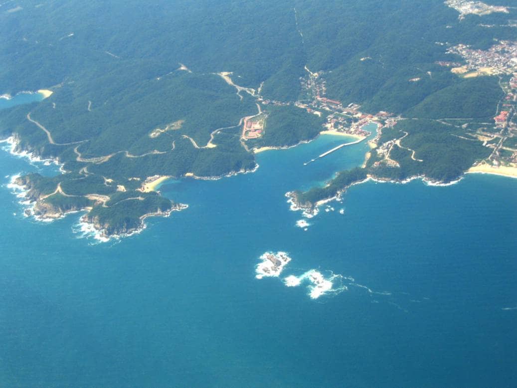
Sailing from Puerto Vallarta to Hualtalco is basically following the coast line of Mexico. By staying at least 4 miles off the coast we are in deep water all the time and the meandering of the coastline itself might increase that distance on occasion. When we pass Manzanillo it is about 6 miles and by the time we reach Acapulco it has increased to about 18 miles and then it becomes less again. With beautiful weather and hardly any traffic the navigators were really enjoying themselves and also the bo’sun was a happy man, as with following wind you do not have brown boobies circling around the bow area and bombarding the bow with “white splashes” They prefer that the ship creates an up wind around the bow and for that it needs to go faster than the following wind, or have the wind against us, or wind still weather. With a wind force 5 in the back and the ship doing the same speed more or less, there was no updraft around the bow and thus no birds circling around. Continue reading
It was a beautiful morning by the time we approached the pilot station. Still dark, but clear skies and no wind. The temperature was a very cool 61o F/16oC; a good sign, indicating that it would not be a too warm a day. So it was to be as by lunch time the air temperature peaked at 75oF instead of the 90oF it can reach. Perfect weather for sightseeing and lingering around the pool on board. The pilot boat came out early and my fears about the party hangovers from the day before did not become reality. There was some effect though, because when we were docking it was clearly visible that the linesmen pulling the ropes ashore, were not as eager and spritely as usual. We were the only cruise ship in port and thus assigned to dock number one. If there are more ships, then there is a pecking order with the biggest ship being assigned to dock one and the others to dock 2 or 3. It is assumed by the authorities that dock 1 is the most preferable one. No doubt the shopkeepers in the flea market, just outside the gate agree with that but I prefer dock 2 as it is opposite Wall Mart and I know the crew love to go there. Continue reading
Today we noticed the change in temperature, both air and sea water when we passed Cabo San Lucas which is called the Cold Cape for that reason. Until noon time we had been sailing in the California Current, which comes from the North and thus transports colder water towards the Equator area. That gave us a nice push in the back and saving fuel is something that always makes us happy. The colder water (around 55oF/13oC) also keeps the outside temperature down but that all starts to change when you come to the end of the Californian Peninsula. Here the California current turns away from the coast and start flowing to the West towards the mid of the Pacific. Its place is being taken by the North Equatorial current, which comes up from the Equator area and thus transports warmer water towards the North. That means we will be sailing against it for the coming days. That will cost more fuel and makes my chief engineer very unhappy. Continue reading
From San Diego to our first port of call Puerto Vallarta it takes two days as we have to cover a distance of 1036 nautical miles. If we would run full speed, then we would arrive around midnight, so we run at 75% capacity and that will get us there by sunrise which is a perfect time to enter the port. No glare from the sun, no land wind generated by the sun and no “Sunday sailors” to sit in the way of the ships approach. These two days at sea we simply follow the coast line of Mexico at distances of anywhere from 3 to 20 miles, depending on where the coast moves away from the ships course line. We try to sail straight course lines where possible and as the coastline is not exactly straight, the distance to the shore varies. Our highlight tomorrow will be when we pass by Cabo San Lucas. If there is not too much traffic in the way then I will do some sightseeing. Continue reading
And so real life started again, after vacations visiting Holland & Malta, honey do lists and lots of Holland America hobby work, I returned to the Statendam today. As we are on a regular run where there are not that many changes in the routine of the ship, so after 3 hours of hand over my colleague could give me his pager and he went off for a well earned vacation. I will see him again on 17 June in Vancouver. The schedule of the ship is that we will continue Panama Canal Cruises until the middle of May and then move up to Vancouver for the Alaska season. That will last until the end of September after that we return to the Panama Canal run and a 30 day south Pacific cruise in December. As is normal, the ship captains split up the Alaska season and thus I am doing the beginning and the end and my colleague the period in the middle. I will be back again on the 16th of September and that will mean that I will do that 30 day cruise and then will be off for Christmas again. I have updated my sailing schedule (under the tab Notes for the Reader) accordingly. Which can of course be subject to extremely much change. Continue reading
Good morning,
Currently at home and enjoying my leave. I am spending a lot of time digging through the companies history. I have now found sufficient information to upload the biography of Captain Bonjer, the first company’s commodore. I managed to trace a nephew who is now alerting the other relatives so hopefully the bio can be expanded in the future. I am currently working on other bio’s as well, so hopefully I will able to add some more in the coming month.
Capt. Bonjers bio can be found under the Captains from the Past listing on the right hand, drop down box, side of this posting.
Best regards
Capt. Albert
Captain Albert

© 2026 – Captain Albert's Website and Blog –
Theme by Anders Noren — Up ↑