Departing Ponta Delgada is always a sort of non-event. Give the ship a kick ahead, make sure the pilot gets off as soon as possible and then sail straight out. Because the island of Sao Miguel makes a sort of nick in the middle we have to sail for a little while on the slight south easterly course and then we can turn to the North East once clearing the island. We followed the Royal Princess out and then left her to starboard. She is going to Lisbon and that is more to the south than Brest and thus we are heading on a steep North Easterly course directly for our next port. That keeps us well clear from our next weather hot-spot, the Bay of Biscay. For those who think that the weather is only bad in the Bay; that is not correct, it can be bad on the whole ocean, it is just then a little bit worse in the Bay itself. Why is that?
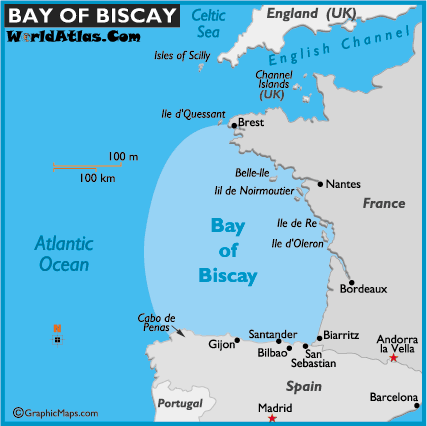
Really it is much more than a bay. It covers more or less the whole west coast of France. The bad bit is the South East corner starting at Cabo de Penas. (Courtesy map Worldatlas.com)
Because the storm rolling in from the north Atlantic gets in stuck in this corner called the Bay of Biscay. The wind can continue overland but not the waves. They are forced to run ashore, have nowhere to go, bounce back and build up in height. So the ripple that wants to continue “rippling” through the ocean cannot do so and some of its energy ripples back again, and hits the ripple coming in next. This gives a sort washing machine motion with very high waves which are not all of the same length and same height and that can make for a very unpleasant ships movement if you get into a storm here.
Not the entire bay is deep and over shallow area’s the waves can build up even more, sometimes resulting in a port being closed. Then even during good weather, the swell of a past storm can still remain and create a very unpleasant situation when you leave the port of La Coruna (or A Coruna in Spanish). I have included below one of the very famous photos of the Fred Olsen cruise ship Balmoral who left La Coruna and met these high and irregular waves. There is not much you can do about it except either stay in port and wait for the swells to subside or sail against the waves very slowly so you ride them but not hit them. I have done that in the past with the ms Prinsendam a few times where we just sailed out of port with 3 knot speed until we came in deeper water where the swells were less steep. Once in a bit of deeper water you can start edging up the speed and try to find the right balance between the ship not moving too much and still getting some mileage made to get to the next port.
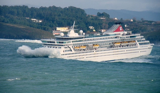
Very nasty if you get into something like this. Important to sit down, hold onto your drink and wait for deeper water. (Photo courtesy via www.captaingreybeard.com)
As a result of this nasty weather we see it often for the French port of Bordeaux that the pilot will arrive by helicopter because the seas are too rough for the pilot boat to come safely alongside. Sailing to Bordeaux you need to enter the river Gironde and there where the sea and the river meet, things can also be extremely nasty at times. Only smaller cruise ships go up river to Bordeaux as they have to fit under a bridge and be able to turn upstream for the downward journey again. Somewhere in the year 2009 in the blog archives you will find my exploits about going to Bordeaux with the Prinsendam. You go up the river with the rising tide and you can only come down again when the flood brings enough water to the port and the ebb has not taken too much water away yet. And then you have to go over the bar at the estuary back into the Gulf of Biscay. Luckily it is not all bad and in the summer months and into early autumn it is normally quite peaceful here.
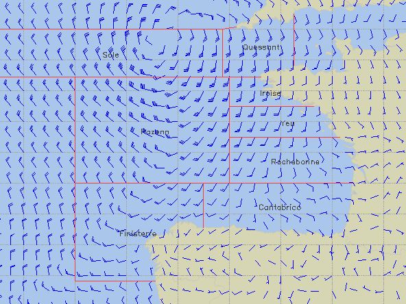
This is the weather forecast for 27 April which shows a small but intense pressure system laying at the edge of the English Channel. It will cause some windy weather in Brest. Unless it clears up or fills in tomorrow.
Our course keeps us will in the open area of the Bay of Biscay and even when we approach Brest we are not in the really “exciting” area of the Bay. Our course keeps West of Cape Finisterre on the North West point of Portugal and then we will approach Brest in open waters, directly heading for the pilot station. At the moment it is extremely calm in the Bay and will remain so for the next two days. But the weather gods are not doing the same off the coast of Brittany. The day we are in Brest a small depression is scheduled to pass over bringing a very windy day to Brest and then a calm day the next day for Cherbourg.

April 25, 2018 at 2:07 pm
Seeing the photo of Balmoral causes me to ask — have you ever had to deal with “rogue” waves? I remember seeing videos of a wave coming through the front lounge on a cruise ship (Norwegian Majesty as I recall) creating all sorts of havoc. Best to you on your travels and thank you for your informative and entertaining blog.
April 26, 2018 at 11:23 am
Thank you for reading my blog.
The last one I remember that a company ship encountered was on the old ss Rotterdam where it shattered bridge windows
75 feet above water. Since then nothing. Luckily nowadays with infra red satellite. wave heights can be measured and
thus everybody has a pretty good idea where they are, and when, why and where they are formed. The Norwegian Majesty
was quite unfortunate that it came very un-expected.
Best regards
Capt. Albert
April 26, 2018 at 9:43 pm
Thanks, I bet you have seen some pretty nasty weather in your career — probably avoided most of it except when caught by surprise by mother nature, who can be wicked.