Today we have our 2nd day at sea and we are sailing with a speed of 15 knots towards Half Moon Cay. We have outrun the bad weather and now we have just the regular Trade Winds blowing, although they are quite strong ones, reaching wind force six at times. Normally for a Trade Wind is a strong wind force 4 or a small 5. Still the sun is shining and that is what counts, the decks are open for the guests, much to the great relief of the Cruise Director. Because today was the “Walk for the Cause” and that is something you do not want to cancel. Thus far the company has raised over $ 6 million in funds for the Cancer Fund (and part of it goes to the Cancer funds in the home countries of our crew members) and a lot of good work can be done with that money. So by 11 am. we had about 40 quite excited guests getting ready to make the rounds on deck after having bought the T shirt. They had the additional benefit of seeing Cuba on the portside as we were just sailing into the Windward Passage.
Holland America Line has 15 ships and if you add the 5 of Seabourn to it, then it is a 20 ship fleet and they are sailing everywhere. In the old days that was fine and as we called it “a ship would go under water at Lands’ End and would re-surface at New York pilot station” and in between only the Captain knew where the ship was. With the arrival of modern technology this started to change and the first thing was that various Coastguards started to monitor ships sailing along their coasts. A good example was Seattle Traffic, which monitored the American side of Strait Juan de Fuca and the Pudget Sound. (The Canadians did their side with Tofino Traffic for the approaches and Victoria Traffic for the Canadian Inside Passage) In the beginning it was VHF only and the movement of all the ships was plotted on a big table chart and by actually moving little ship models or that chart. Then came a better quality radar and the ships received AIS transponders (Automated Identification System) and now everybody can see where a ship is where it is going and what sort of ship it is. Dedicated Websites on the internet.
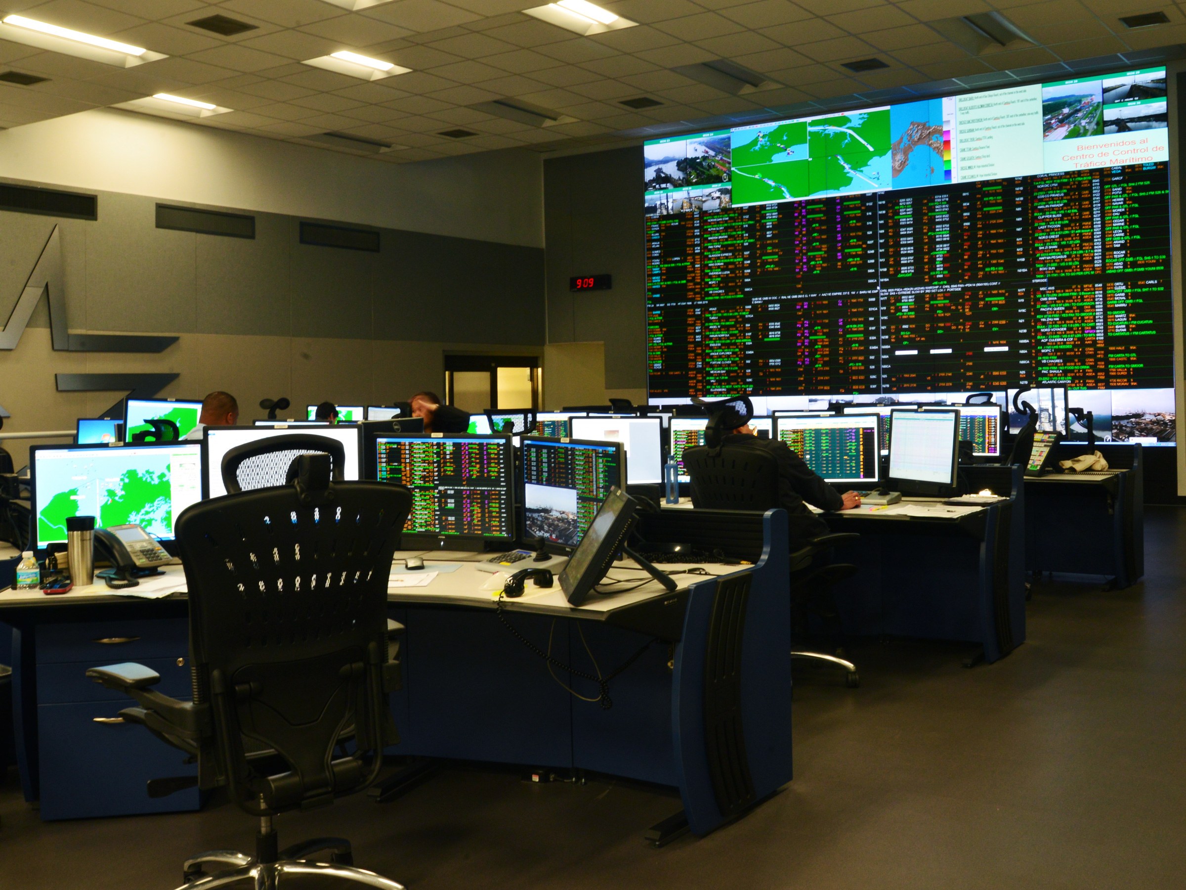
This is Traffic Control of the Panama Canal. Keeping all those ships efficiently under control is no mean feat.
That left the situation of How a Ship was going where. It was up to the Captain’s responsibility to do that safely. Fast Forward to 2012 and the Costa Concordia. Then we learned that Captains were not always doing it safely and sometimes squeezed the margins a little bit too close. As a result Carnival Corporation decided to beef up their Emergency Response Centers (An Existing system to support a ship if something had happened) to Fleet Operations Centers so they could follow the ships 24/7.
Carnival has one in Miami (https://www.youtube.com/watch?v=1G_DkLDF-rE), Holland America/Seabourn in Seattle, Princess in Santa Clarita and Aida/Costa in Seattle. For the smaller company’s such as Cunard and P & O, Miami acts as its operator. And in case of a major catastrophe, Miami can also take over for the whole fleet.
Our Fleet Operations Center (FOC) is in our Head office in Seattle and they have a 24/7 watch system there manned by navigation officers who came shore side. (Mostly because “she who shall be obeyed said so”) Apart from following the fleet, they also help if we cancel a port or to find another destination or if the captain needs more in depth weather information then they try to find it. If for a Medical evacuation the ship has to deviate to another port, they will also help with arrangements. Thus each cruise, each ship uploads the voyage plan and then the FOC follows the ship according to this voyage plan. If the ship decides on a major course change (say going around Hawaii on the opposite side than planned) then the captain will give them a call to advise what is going on. This is called passive monitoring. There is another option, which is called active monitoring, and then the ship has to call before it plans something major.
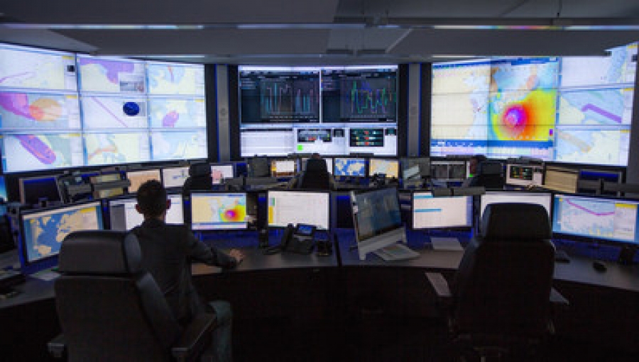
This is our Seattle Fleet Operations Center. The place is manned 24 hrs. a day 7 seven days a week with operators out of the cruise industry so they understand the circumstances in which a Captain will call. If a crisis starts to develop then stakeholders from the various departments in the office will join in.
What is something major? That is in the voyage plan. When we sail we design a Path width, a sort of private highway on which we will stay, taking into account expected course changes for collision avoidance etc. That path width depends on where the ship is sailing but the logic shows a boundary/ borderline that normally you do not go outside of, unless something drastic is occurring and then the FOC needs to know. The captains in general do not mind this constant monitoring / scrutinizing very much as the FOC has opened up the option to push a lot of organizing work to them, work a captain otherwise had do himself when it comes to cancelling ports etc.
If a major incident would happen, then the FOC changes into an incident / crises center and all the movers and shakers, read vice presidents, are coming in to provide expertise. PR, Technical, Nautical, Hotel Operations, Environmental; all to support the ship and to communicate with the outside world. For the latter the President will needs to be briefed and Carnival Corporation, so the right information is disseminated to the right channels.
So the FOC knows that we will be at HMC at 08.00 hrs. tomorrow morning and they will see two voyage plans merging there as we will be together with the ms Koningsdam. They will have looked at the planned weather to see if they need to advise the Captains and /or if they can expect the captains to phone in with the decision that they are cancelling. For tomorrow the weather looks good, sunny and warm, only the wind is expected to be just a touch too much to the south for a perfect anchorage day, but then life is never perfect.

March 17, 2019 at 11:18 pm
Captain Albert:
I find your posts to be informative and educational. Thank you for all your good work!
March 18, 2019 at 4:41 pm
Captain A
I may have asked this before, if so forgive me. Can you translate wind force 4, 5 and 6 into miles per hour please?
Thanks and regards,
Roger T
March 22, 2019 at 6:49 pm
I am especially interested in the information you have shared in this post. Our Prinsendam voyage in December had a scheduled Dominican Republic port primarily for beach time. The weather forecast indicated an all-day rain in that area so our captain announced a different port also in the Dominican Republic where we enjoyed a wonderful blue-sky day at a lovely beach resort. I wondered what effort it took and who managed all the planning to make it happen.
March 22, 2019 at 9:24 pm
Thank you for reading my blog.
if the weather turns for the worse in a local area we have already a plan B up our sleeve. The plan B possibility really depends if the port or anchorage can handle the size of the ship. The smaller the ship the easier it is. and of course our little Prinsendam has much more flexibility than an Apartment of the Seas. Thus the moment the captain makes the decision it can take only 30 minutes or so to move all the needed infrastructure around the corner if it is not too far and in the same country. If the ship has to sail to another country it is often between 2 and 4 hours to get the authorities going. Some ports are standard prepared for it. As an example Cherbourg. On a regular basis the ships have to cancel Guernsey if the wind is from the wrong direction. 3 hrs. later the ship is docked in cherbourg and all new tours and buses and the local shuttles are waiting. If you want to dig in the archives of the blog. Look at 26 December 2011, boxing day. We were scheduled for St. Barts but Ambramovich’s yacht had pinched my anchorage (his yacht is about the same size as the Prinsendam………..) so I sailed on to Antigua. The whole story of how we did it is in the blog for that day.
The Prinsendam guests thought it was wonderful, they did not care where we were going, they were all placing bets of where I would be going.
Best regards
Capt. Albert