What the English language calls the Baltic is called by the Dutch and the Germans the Oost zee, or OstSee, or translated the East Sea. Logical as it is to the East of those countries. But it causes confusion sometimes when a Dutch sailor in his best English advises a Harbormaster in an English port that he came with his ship from the EAST SEA. But for the international world the word Baltic is used and it is a bit uncertain where it is derived from. Wikipedia gives at least four options, but to me it seems that Sea behind the Balts = the Belt Islands between Demark and Sweden is closest to the most viable options.
So we plunged last night into the Baltic Sea after we came out of the Kieler Kanal and had sailed through the Kieler Bight. The Baltic Sea is a shallow sea and if they would close the entrance to the Baltic off at Helsingborg and Helsingr then you could have extended valleys of dry land here, interspersed with mighty rivers carrying all the drainage water from the various countries. The mind boggles what would then happen to the ships, the local infrastructure but also to the boundaries of the surrounding countries. For that reason there is a description in the Finnish language of the Baltic being the “Peace Sea” as through the centuries it kept the various warren factions somewhat apart. It did not always work but the water required those who were intent on conquest to build ships and others to spend their money on forts to protect them. If the sea had been dry land, then any major army could have just marched south or north and things would have been greatly different.

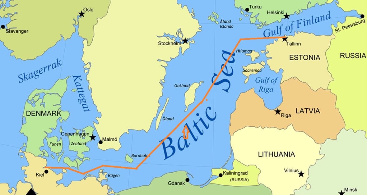
Our Route through the Baltic Sea. Going North we are favoring the Polish side; coming south we will favor the Swedish side.
The Baltic Sea has always been an important trading route from spring to late autumn. Then the sea would freeze over and all the ships would have to wait until the next spring. Nowadays the icebreakers are so powerful that the ports can be reached all year round as long as the ships are following the exact track made by the icebreakers. For the cruise ships that is not much of a challenge we are only here in the summer time. But we still pass the islands that were important points and landmarks for the old navigators in the sailing days.
One such is the island of Bornholm. Located halfway between Poland and Sweden. In the Dutch language we have a saying “achter Bornholm liggen”, to lay behind Bornholm. This referred to what the ships would do if there was a storm blowing. You can shelter behind the island in all directions so where ever the storm is blowing from, you can find shelter at the opposite side behind the island. This was done so often that the phrase became part of the Dutch Language and was even used by those living far far from the sea. There are extensive ferry connections with the island and there is the port of Ronne on the west coast. A ship as the Prinsendam is about the biggest size that fits inside but larger cruise ships will have to anchor.
Today we did not have to lay behind Bornholm as the weather was really good. So we kept Bornholm nicely on our port side and sailed further up the coastline, passing Gotland also on the portside around 17.00 hrs. this afternoon. Gothland is home to the town of Visby which we will visit later on in the cruise. Because the Baltic Sea is so very busy there are assigned shipping lanes everywhere and Bornholm is used as a sort of Separation Island. If you are out of the Baltic and up past Denmark to the North Sea then normally you stay north of Bornholm. Coming into the Baltic and going north, you normally you stay south of Bornholm.
Around midnight we will change course to starboard and sail into the Gulf of Finland with the aim to be docked in Tallinn by 07.00 in the morning. Tallinn is on a different time and thus the whole ship will go forward one hour tonight. The port now has two large dedicated cruise piers and the cruise ships do not dock in the old port anymore. That is now reserved for the ferries of which a greater number call in every day. For the guests it does not make much of a difference. The length of the walk into town is the same length and with the modern pavement it might even be easier than the cobble stones near the old docks.
The weather for tomorrow is supposed to be sunny with temperatures in the high sixties. There is talk about a breezy day but I hope it is not too much as I am examining the sailors tomorrow to extend their competency certificate as Tender Drivers so we going to mess around with boats so to speak.

June 7, 2018 at 8:00 am
Great map…helps to understand the Kiel Canal better…and why it is in that location.