It was busy during the night when sailed around the south point of the Peloponnesus. I counted 75 ships on the radar at one given time in a radius of 24 miles. They all behaved as they should but we had a little excitement when 3 miles ahead of us a little German coaster suddenly flipped on all his red lights. Five seconds later a very German accent came on the VHF announcing that he was not under command (e.g. could not control his ship) as there was air in the fuel lines to the main engine. Main engines do not like that very much so his engine had stopped operating. While they were solving that issue, the little coaster was drifting help less right in the middle of the shipping lane. Continue reading
Author: Captain Albert (page 196 of 238)
With a flat calm sea and the sun rising over the horizon we arrived at 07.00 at the pilot station of Katakolon. Ahead of us was the MSC Musica which was scheduled to dock at the outer breakwater. This is a 90.000 ton ship and carries 2500 lower beds and over 3000 when full. That spoiled it a little bit, as Katakolon is a little bit too small to take such an invasion. However she was only going to stay to until 2 pm. and thus our guests had the town all to themselves during the afternoon. The good news was that we, being the smaller ship, could dock at the downtown pier and that meant less then a 1000 feet to walk to the town with it’s shops and tavernas. Katakolon is a very nice place to go to. Continue reading
 Captain Albert Schoonderbeek
With a flat calm sea and the sun rising over the horizon we arrived at 07.00 at the pilot station of Katakolon. Ahead of us was the MSC Musica which was scheduled to dock at the outer breakwater. This is a 90.000 ton ship and carries 2500 lower beds and over 3000 when full. That spoiled it a little bit, as Katakolon is a little bit too small to take such an invasion. However she was only going to stay to until 2 pm. and thus our guests had the town all to themselves during the afternoon. The good news was that we, being the smaller ship, could dock at the downtown pier and that meant less then a 1000 feet to walk to the town with it’s shops and tavernas. Katakolon is a very nice place to go to.
The only thing with the downtown dock is, is that it is sitting on a crack in the earths crust and sulpher fumes come up through the water. Not much, but just enough that when you step of the gangway, you get a whiff of rotten eggs. I announced that yesterday to the guests so that they would know it was not sewage or something. It is a sort of low density sulpheric gas. If you go to thermal bath you have to pay an arm and an egg smell but here in Katakolon you get it for free.
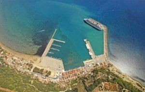
The new pier is one sticking out from the promenade of Katakolon. The bigger ships dock at the inner breakwater.
A peculiar thing was today that my blog was involved in bringing two old friends together. A while a go I received on the Captain Albert email a request from a gentleman who was trying to trace the pilot in Katakolon. He had spent a long period in the town in 1998 when he was there stationed with a tugboat. However he did not know if the pilot was still the same and where he lived. So this morning I gave a print out of the email to the same pilot as then and of course he remembered this particular young man. When the pilot returned to the ship on departure, he told me he had already sent an email to Romania to get in touch again.
As with most small ports, the pilots are multi taskers who run several operations at the same time, just being a pilot does not bring enough money in the kitty. So he has a very nice restaurant in the town on the promenade. He owns the pilot boat and he has a share in the tugboat stationed in the port. The pilot boat can also be used as a ships tender and quite often employed by the cruise ships at anchor. I remember using it with the old Noordam in 2001, when I was pressed for time. I got my own tenders home early and then used the pilots tender for the final run which saved me at least 30 minutes on departure. You have to announce it early though as the pilot has to make sure that his boat driver does not go for a “happy day” ashore. Most of the time a “very happy day”.
I always have to laugh when this pilot is standing next to me, as you can put the clock on it, that by 07.30 his cell phone rings with his wife on the line. Telling him to hurry up with docking the ship as he has to take the children to school and to open up the restaurant. So I try to have the gangway out by 07.25 to make sure that he does not run into a domestic argument with his wife or his mother who is the cook of the restaurant. You can spend a leisurely day in Katakolon but the main attraction is going on tour to Olympia. There is also a good train connection for going in land but while there were close to 4000 people in town, the railroad workers thought that this was the most appropriate time to go on strike and so the trains were not running.
We were ready to sail on time and with a bit of a windy departure, I backed the Prinsendam out of the harbour and 20 minutes later we were on our way to Navplion which is located at the other side of the island. The Peloponnesus was originally a peninsula but since they dug the Corinth Canal it is now an island. We will travel during the night around the Southside of the island and by midnight go through the channel North of Kythira. This is the shortest route from the West Med to the East Med and to the Black sea and so we normally meet about a 100 ships here. As those ships are not always behaving I will have to be on the bridge for most of the night.
However the weather tomorrow in Navplion looks great. Sunshine all day, little wind and temperatures in the high 70’s. to low 80’s.
To access Captain Albert’s historical writings on Holland America Line as well as photos and additional information about Prinsendam and his sailing schedule, click here.
Captain Albert Schoonderbeek
On this cruise we will be sailing through the Straits of Messina twice as the cruise is a loop cruise to and from Civitavecchia. As the stretch to Katakolon is not a very high speed run, I set the speed in such a way that we would be passing through the Straits around coffee time. That meant Stromboli at 8 am. so those who went for breakfast around that time could see the volcano cone on the port side. It was a bit hazy when we passed by with the smoke being absorbed by the clouds so we did not see any plume at all.
Pilotage for Messina is compulsory for big ships but it only takes about 20 minutes and it all goes very fast. Sometimes I wish that I could send the pilot boat drivers from other ports in the world for a course to Messina as it is amazing what they are able to do here with their boats. Most places you have to slow down to 6 – 8 knots, make a lee, change course again etc etc. Here the pilot boat comes alongside with 16 to 18 knots of ships speed and only request is that we keep the swell away from the pilot ladder area. Basically you can just continue your journey while doing a pilot transfer.
On this cruise we will be sailing through the straits of Messina twice as the cruise is a loop cruise to and from Civitavecchia. As the stretch to Katakolon is not a very high speed run, I set the speed in such a way that we would be passing through the Straits around coffee time. That meant Stromboli at 8 am. so those who went for breakfast around that time could see the volcano cone on the port side. It was a bit hazy when we passed by with the smoke being absorbed by the clouds so we did not see any plume at all. Continue reading
Captain Albert Schoonderbeek
Today we ended our 20-day cruise from Ft. Lauderdale to Civitavecchia. The cruise was called “off to Rome” and to Rome we made it, at least to the port of Rome. We were blessed with yet another good day full of sun shine and little wind and as we were saying goodbye to about half of our guests, I approached the port early. Luggage had to be taken off and then there was the ride to the airport near Rome. Traffic in the Rome area can be horrendous and thus a timely departure from the ship is of the essence and then it helps if I dock the ship on the early side to give the Hotel department a good head start.
We were not the only ship in port. Apart from the regular ferry traffic was an Apartment of the Seas (Voyager with 3100 guests on board) and the Grand Celebration with 900 guests. (This is the old Carnival Celebration which now sails for the Carnival subsidiary Ibero Cruceros of Spain. With a base capacity of 1500 beds, the ship was not very full). What also was not full was the container terminal and the new car receiving area next to our dock. It was distinctly empty, a sign that the recession is still in full swing. The port has recently extended the terminal area by filling up part of the North side of the harbour but it looks like that they will have to wait for an upswing in the economy before more cargo ships are coming in. However the container dock is shared with cruise ships and thus the investment is at least partly paying off.
Today we ended our 20 day cruise from Ft. Lauderdale to Civitavecchia. The cruise was called “off to Rome” and to Rome we made it, at least to the port of Rome. We were blessed with yet another good day full of sun shine and little wind and as we were saying goodbye to about half of our guests, I approached the port early. Luggage had to be taken off and then there was the ride to the airport near Rome. Traffic in the Rome area can be horrendous and thus a timely departure from the ship is of the essence and then it helps if I dock the ship on the early side to give the Hotel department a good head start. Continue reading
Captain Albert Schoonderbeek
Another beautiful day and another beautiful port. As Monte Carlo is facing east, it is always a pleasure to approach the port in the morning as the rising sun shines over the whole area. Apart from a few fishermen there was nothing in the way. The Sunday sailors and gin palaces were still happily tucked away in the harbour and so we could proceed unhindered to our anchorage. As we were banned to Fontveille, due to the preparations for the Grand Prix, I had to find another anchorage. Our regular anchorage is just to the North of the new pier. Right abeam is the Hotel under which the race cars run their race, but using that location now would result in a much too long a tender distance. When going further to the South, the water gets deeper and the only shallow place that is really nice for anchoring is prohibited. The Oceanographic museum has some sort of water inlet system at the bottom of the cliff and thus we cannot drop anchor there.
The Captain of the Azamara Journey was obviously suffering from the same problem and decided to anchor all the way to the south. So far that I thought he was going to run his tender service into the marina of Cap Agile. However the boats were also going into Fontveille making it a long distance for them. As it was nice weather and no wind expected, I had no problem with dropping the anchor in 80 meters of water (240 feet) and could thus keep the tender distance to the port to a minimum. Dropping the anchor is really the wrong phrase here; with such a water depth we lower the anchor on the windlass, shackle by shackle, all the way down. (A shackle is one link of the chain, which is about 30 centimeters) Because of the depth most of the chain is hanging vertically and thus you are never certain if the anchor has dug in when the ship is in position. You can simply not see how the chain is leading and where to.
Another beautiful day and another beautiful port. As Monte Carlo is facing east, it is always a pleasure to approach the port in the morning as the rising sun shines over the whole area. Apart from a few fishermen there was nothing in the way. The Sunday sailors and gin palaces were still happily tucked away in the harbour and so we could proceed unhindered to our anchorage. As we were banned to Fontveille, due to the preparations for the Grand Prix, I had to find another anchorage. Our regular anchorage is just to the North of the new pier. Right abeam is the Hotel under which the race cars run their race, but using that location now would result in a much too long a tender distance. When going further to the South, the water gets deeper and the only shallow place that is really nice for anchoring is prohibited. The Oceanographic museum has some sort of water inlet system at the bottom of the cliff and thus we cannot drop anchor there. Continue reading
Captain Albert Schoonderbeek
The distance between Naples and Elba is just too long to have an early morning arrival and so we were scheduled to be there at 10 am. That is a decent time anyway. Time for a leisurely breakfast on board, followed by a nice stroll into town. Having the best of both worlds. It was indeed a beautiful day and when we approached the island from the West, the sun beamed its rays over the green hills of Elba. We approached from the West as the entrance from the East side is a bit tight. Although there is enough water, it has several death angles (e.g. you cannot see around the corner) and if suddenly a fisherman comes in the way there would be nowhere to go but to put on the breaks very hard. Engineers do not like that very much so I prefer to go through wide open waters if the ship has a high average speed to maintain.
By 0850 we were at the pilot station and a very happy pilot came on board. We were his only job for the day and so he was bringing some money home that day. We were directed to the middle of the anchorage just in view of the harbour. There was a pier available but it was just too short for the Prinsendam to fit at. Next time when we come back it should be ok as they going to extend this pier during the coming winter. However as mentioned yesterday, the tender run into the port is very scenic and gives a nice overview of this most charming Italian town.
Captain Albert

© 2026 – Captain Albert's Website and Blog –
Theme by Anders Noren — Up ↑