Last evening we sailed out of the protection of the Bahamas and Cuba and came into the open waters of the North Atlantic. The area is fairly quiet, or better said the North Atlantic further North of us is fairly quiet as there is not much of a swell rolling in and thus the Oosterdam is sailing through the water in a nice and stable way. Good for everybody, as they could enjoy a carefree sunny day. For most of the day we sailed above the Dominican Republic and then during the night we will cross the Mona Passage located between the Dominican Republic and Puerto Rico, with the plan to arrive at the pilot station of San Juan at 09.45 in the morning. We arrive at 09.45 at the pilot station because the Crystal Serenity is scheduled for 10.00 hrs. She is going to berth 1 west while we are going to 4 West. The docks are counted from the sea inwards and thus if we sail in just before the Crystal S. then we do not have to wait for them while they make the turn into the 1 dock as 4 dock is further inwards.
I mentioned yesterday that we were expecting two other ships but in the meantime the list has become much longer. We will now be joined by the Eurodam (docking next to us) the Freedom of the Seas , the Regal Princess, the Crystal Serenity, the Silver Wind and the Club Med. Which means it is going to be busy in San Juan. Even when keeping the pax. count low, we are looking at 12,500 guests coming ashore from the ships, sometime during the day. It will certainly mean that the T shirts will not be on discount tomorrow.
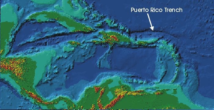
The Puerto Rico trench running from above the Dominican Republic to the East.
Sailing towards Puerto Rico, we come across a natural phenomenon which most guests will not notice as it located under water. It is the Puerto Rico Trench which is one of the deepest places in the world. Laying to the north of Puerto Rico it has a length of 800 kilometers (497 miles) long and a maximum depth of 8,648 meters (28,373 ft.) or 5.373 Miles. Not as deep as the Mariana trench near the Philippines but still deep, very deep. All the Caribbean islands are from volcanic origin (something you can see very well when we will pass the mountains near Soufriere on St. Lucia) but the whole area is dormant. The mountain range which tops are the islands were caused by a minor tectonic plate, the Caribbean plate, pushing over the much larger North American plate. The North part of this minor plate is now sitting on top of the large plate and has thus cut off the direct connection with the earth’s fluid inner core. Not completely as we still have a very active Volcano on Montserrat, more to the south east, which crated a lot of mayhem a few years ago. The Puerto Rican trench is a crack on the North side of this plate and goes much deeper down than the ocean floor around it, which is not shallow either with depths of up to 5 or 6 thousand feet. Because of the tectonic plate movement and the depth, landsides are easily possible, creating tsunamis and also earth quakes can occur.
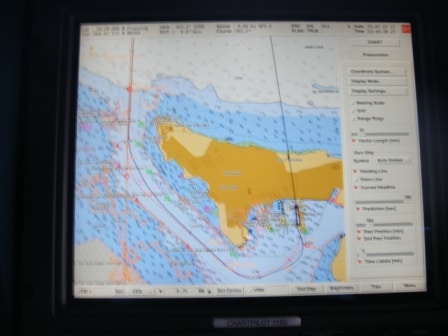
Our course (red) when going in, as seen on the Electronic chart. The black line is the track the ship used last time and you can see with the bulge near the dock that the captain went “high” to compensate for the strong Trade Wind.
When we line up tomorrow morning for going in we will do that several miles from the entrance itself. The sail into port is nearly directly south (the leading lights are 181o, with south being 180o) and to get a feeling for the set of the current, the captain will try to get in the leading lights very early as the entrance is not very wide and the shallows are very close by. Then the pilot will board, outside if it is not too bouncy or otherwise when we are just inside. Once past Morro Castle on the portside, we will lose all the current and most of the wind. Then we have a 50 degree turn to port to head for the downtown docks. San Juan is a very large and natural harbor and there are a lot of docks much deeper into the Laguna than where we are going. Next step is to keep a lookout for small airplanes as they built the runway right in the line of the entrance channel. Then we come to the dock and we turn north again. This will bring the Trade wind full on the sb side of the ship and thus the captain has to ensure that he “stays high” otherwise the ship will drift against the cruise ship docked at pier 3 east. Although we always enjoy visiting the neighbors, drifting against each other is not the way to do it.
We will stay in San Juan until 23.00 hrs. as it is only a short hop to St. Thomas, just around the corner. More about that tomorrow. Weather for tomorrow: Fair chance of showers and 29oC / 84oF with a gentle breeze in the city.

December 6, 2016 at 8:50 pm
There seem to be several islands in the world that have built their runways close to the cruise ship terminals, Captain. I don’t remember which ones you had covered in your blogs. But, I do remember you had to take into consideration the coming and going of airplanes before departing with your ship in some harbour.
December 7, 2016 at 2:58 pm
yes,
like Boston, Oranjestad, San Juan, Castries, just to name a few, where the pilots always check not only what is floating but also what is flying.
Best regards
Capt. Albert