- Captain Albert's Website and Blog -

Ocean Liner History and Stories from the Sea, Past and Present. With an In Depth focus on Holland America Line

Category: excludeRecent (page 1 of 82)

11 Feb. 2019: At Sea.

11 Feb. 2018: At Sea.

Yesterday I boarded the ms Zuiderdam in Willemstad after having been on vacation since December 18 after leaving the ms Nieuw Statendam when it ended its maiden voyage in Ft. Lauderdale.

During my vacation time, the IT gurus of Holland America have been moving my blog to a separate server for operational reasons.  It should not have affected anybody as I am still linked through via the HAL blog but you can also reach me via www.captainalbert.com.

Never a dull moment when you work for Holland America. Continue reading

17 December 2018; Crossing the North Atlantic, day 7.

Today we are exactly a week at sea and we are almost there. North West Providence channel is now rapidly coming closer and that is where we will see land again for the first time. Bahamian Islands to starboard and to port, visible to eye if the weather is clear.

Here at sea the weather was not very clear and Mother Nature had decided not to listen to what the meteo guru’s in their infinite wisdom had pulled out of their computers. On a wide open ocean, it does not take very much to change a regular pattern of weather. And that is what happened last night. I was bravely hoping for a real Caribbean day, with lots of sunshine, and what we got was still a Caribbean day but the rainy version.  A long band of rain had been laying over the east coast of Florida and it was supposed to come over tonight. No problem for us, everybody inside enjoying the music walk and the Bo ‘sun outside enjoying that his ship was de-salted free of charge.

Quiet times at Cape Hatteras. Patches of 12 feet of swell is really nothing compare to what it is capable of.

But the frontal system decided to speed up, most likely caused by the fact that it is unusually quiet at Cape Hatteras at the moment and the weather system was not pulled that way. So it came our way and all morning dark and gloomy clouds were surrounding the ship and on occasion also descending upon the ship. By lunch time it started to clear up but it will not be before tonight that it should all be gone. Unless the weather front decides to stall, then we will still have some of it tomorrow. But still, the seas are fairly calm, we just have some chop and wind caused by the weather front and the ship is riding nicely through it all.

And this is the rain picture we sailed today through the lower tail of the weather system. (Photo courtesy www. Weather.com)

A guest commented today, that he has seen so few ships since leaving Funchal, and he was correct. Although there are plenty ships out there the area is so vast that even if they go the same way, they might just be outside the range of the eye. The earth curves and thus you can only see so far. On the bridge which is about 75 feet above water, we can see between 10 and 15 miles depending on the clarity of the air and the size of the object. At night we can see ships about 6 miles away as that is the requirement for the strength of their navigation lights. On our commercial radars we can pick up a ship at 48 nautical miles and sometimes even up to 96 miles. The Navy has much better gadgets again and can do several hundreds of miles without any problem.

This is a shipping pattern that you can plot if you keep adding the transponder trails to the same route over a period of time. It shows most of the traffic near ports and a general trickle going South East of Freeport, there were we are coming in.

But the main reason for not seeing many ships is, that our route is not a main shipping route. There are not many ships who ply between Funchal and the Bahamas and thus we are really alone. This route only sees traffic in spring and autumn when the cruise ships are migrating. Most ships coming from or going to the American continent, follow the  Gulf Stream  and make an educated guess between sailing in the nicest weather (and making good speed) or  taking a bit of turbulence (and losing some speed) if in the balance they still make the best time. Cargo ship engines are the most efficient when going full speed. So those ships race full speed to their destination and when they arrive, drop the hook if they have to wait for a berth. Then the expensive main engine goes off and a small auxiliary or donkey engine provides the little bit of power that is needed to keep the ship going.  So for them it is not so important to have nice weather but combined circumstances that equate to the lowest fuel consumption.  The Gulf Stream in the back helps them save a considerable amount and thus they start their crossing most of the time just under Cape Hatteras. That does not give the best of weather but they will have following storms and that does delay a ship much less than have to battle against a storm.

A nice aerial photo which shows the Grand Bahama Bank, the islands and other sandy patches. (Photo courtesy NASA, so I assume this was taken from space)

Tomorrow is our last day at sea. Then in the late afternoon we will enter the Bahamas, between South Abaco Island to the North, and Eleuthera Island to the south. The body of water is called the North West Providence channel and are near the gap on the Abaco Island side is called the “hole in the wall” quite appropriately.

16 December 2018; Crossing the North Atlantic, day 6.

As promised by the weather forecast, the wind and swell out there indeed abated. The wind shifted from the West (the very last tail of the storm system) to the South East (the beginning of the Trade winds) and is now behind us but it is not blowing very strongly. Swell can only die down when the wind abates and when that happened in the early morning the swell came down as well a few hours later. Out there the ocean is still not flat (whenever have you seen an ocean that is flat?) but we are now down to the long low rolling low swell of a North Atlantic at its most tranquil.  We still see the occasional white cap, indicating that we have winds somewhere between 3 and 4 Beaufort and that is also normal North Atlantic weather. If you get real calm weather in this area, when the winds are completely becalmed and the seas look oily, then you better brace yourself as that indicates that “silence before the storm”.

The wave/ swell chart for today. Look at all that nice blue. As long as that green stuff near Cape Hatteras is not coming down we will have flat calm weather all the way to Florida.

There are areas around the world where it can be very wind still. But that is not normal for this area located just south of the North Atlantic storm fields. Here you always have a little bit of wind, either being remnants of storm systems, or the northerly rim of the Trade Winds. And we are coming closer and closer to the Trade Wind area. Most people identify the Trade Winds with the Caribbean Sea and that is not incorrect. But the Trade Winds are not there because of the Caribbean, the Caribbean area is simply in the way of the Trade Wind system.

The worlds wind system. As you can see it all curves west ward at the equator. Thank you NOAA.

But let’s first look at the bad weather and swells. Most people will have heard about the roaring forties, furious fifties and screaming sixties. Names out of the good old days of the Tall ship sailing. These names refer to the sea areas in the southern hemisphere between 40/50, 50/60 and 60/70 degrees Latitude. Here the vast open ocean spaces let winds build up unhindered and push the swells up very high and that could make life very unpleasant for the men of steel on their ships of wood. While there is some land in the North (Iceland, Greenland) to the south it is all wide open all the way to Antarctica. That is the reason that there are no cruise ships down there in the northern summer time (which is the southern winter time)

All this wind is blowing in area’s close and closer to the poles. Around the equator things are more benign and that is caused by the inter tropical convergence zone. This area around the equator is also known as the doldrums. The North East Trade winds and the south East trade winds cancel each other out. The old time sailors were not happy in the screaming sixties because the wind blew their sails to shreds, they were also not happy here as the sails did not catch any wind and they would drift around aimlessly. Sometimes for months if they were unlucky.

A rather undignified way of landing a noble animal.

Did the men of steel from those days gone by also have a name for this as well: Yes, they called them the Horse Latitudes. Because when a sailing ship would be becalmed here for a long time and fresh water supplies would run low, the first things that would be killed off to reduce water consumption would be any horses that were on board, bound for the new world. And sailing ships used to carry a lot of horses for the armies in the new world. Some were even landed in the Caribbean. The main port of Aruba at Oranjestad is called Paardenbaai, or Bay of Horses, where they used to come ashore.

But very often horses went by box. an early form of containerization.

We are now just touching the Northern edge of the North East Trade winds and this is a planetary wind which means it blows all year around from the same direction. Where does this wind come from? Well the storm system that went past us to the north for the last few days is moving East pushed by the jet stream on the higher levels. But while doing so, it also displaces air ahead of it and that air/pressure is deflecting down, and then flows back West at a lower latitude. Hence the area we are now entering always has this wind coming from the Sahara area and ending up in the Caribbean.

Holland America Horses, seen here at Half Moon Cay, came the posh way. They walked ashore from a landing craft and live in their own hurricane proof horse shelter. The ship in the background is the ms Eurodam. (Courtesy Holland America Line)

That makes taking the southerly route in the winter so ideal. You avoid the North Atlantic storms, and you get some wind and current in the back while in the Trade Wind Area. Why do we like the more northern crossing in the summer? Unless the cruise schedule calls for Madeira or the Cape Verdes, it is a shorter route and we get a considerable push from the Gulf Stream.

Also we now get a nice push from the elements; I do not think our guests are in a hurry to get home early as the weather is now turning our Trans-Atlantic into a Caribbean Cruise.

15 December 2018; Crossing the North Atlantic, day 5.

We are running away from the nasty storm that passed us far to the north. But they say the sting is in the tail and the tail just got us. The wave field came down a bit further and because we were past it already, the waves were now coming behind us. When the swell hits a ship either on the port quarter or the starboard quarter, then it can develop a cork screw motion; so the ship starts to yaw. It is not a completely regular moment as it depends when and under which angle the following swell will catch the ship and lift it up or let it go down. How much the ship is affected depends on how much speed the swell/wave has and also how fast the ship travels. In principle the ship could go at the optimum speed and would ride the waves, or better said, surf the waves and there would be no movement at all. But as the velocity of the waves is seldom constant (normally there is interference from other waves) it is nearly impossible to make that work. But we are running away from the wave field and thus the ships motion already started to come down around lunch time, the accompanying wind, started to abate as well and we should really enter very quiet waters now.  As the captain said during the voyage from the bridge, this is very good weather for December, and I can only agree with him.

The wave picture of today. You can see how much the wave field has spread out, and as we were expecting a few days ago that we would just skirt the edge of it, we are now somewhat inside it. But it will not for long. (Courtesy www.stormsurf.com)

This means that the ship can count on a normal crossing for the remaining days and we are heading for a 03.30 arrival at the pilot station on the morning of the 19th. That is quite early and we will be together with the Caribbean Princess and the Costa Deliziosa. Around those three Queens of the Seas is a whole slew of cargo ships going in and out and then we had better be early than too late. On top of that we will have our first USCG inspection. Of those there are two each year but this is a special one as it is the first time as the ship is entering a US port for the first time ever.

The USCG inspectors will arrive at 08.00 hrs.  and will stay all day long until just before departure as they will also want to witness the Guest Boat drill. The ship will also have a full CBP crew inspection as it is also the first time the NSDM crew comes into an USA port. These full inspections take place every 90 days and require a face to face verification of crew member against passport. The CBP normally starts with a cruise ship inspection after 06.00 hrs. and thus it helps if the Nieuw Statendam is fully ready by 06.00 hrs. It will take a while for all 1000 crew to get through and in the meantime leaving guests will have breakfast and then disembark, the ship will have a turn over to get ready for the new guests and all the activities of a regular turn over day will take place.

Crew boat drill. All starboard side lifeboats are being lowered in the shipyard during trainings. The boats go down in alternating sequence so they will not sail into each other when sailing away. From the moment the captain orders “abandon ship” we have 30 minutes to get everybody inside and the boat into the water.

And then as soon as all the disembarking guests are off, the famous moment of the zero count, the USCG will want to see a full emergency drill, Fire, mustering, and abandon ship; all the legally required routines. So the turn over activities will dramatically slow down while all 1000 crew will be on hand to show the USCG that they are fully proficient in their duties. I will not be involved as I have to “help” with the zero count. Because I hop from ship to ship, traveling over USA soil (most of the time crossing the dock from one side to the other) I have a special Visa that allows me to do so. Normal crew has a visa that just allows them to travel to ship – straight in, and then leave the ship—straight out. That does not work for me, so I have another sort of Visa which allows me the freedom to travel from ship to ship inside the USA. But that Visa means that I am not regarded by the CBP as a crew member, I am considered a non-revenue Pax. And thus I have to disembark with the Guests in the morning, so the ship can reach the zero count as quickly as possible.

Holland America has being doing boat drills for a very long time. This is a drill on board the ss Statendam (I) around the turn of the century. We had the lifeboats so we exercised but in the days before the Titanic the rules were not so strict, hence it was not required for the crew to wear life jackets, or safety harnesses against falling over the side.  (Own collection)

After the drill, the USCG inspectors will want to see all the safety equipment. See if all watertight doors are closing and if all the fire screen doors are closing etc. etc. And that will take all day. For a big ship, there is normally a group of about 8 or more who will attend. They are very good in working with the ship to ensure that the guests can still sail on time and normally that works out very well. So behind the scenes the crew is preparing and refreshing their memory from the pre sailing drills in Italy and all will be ready.

But we still have 16, 17 and 18 December to go and the last few days of the crossing promise to be very good. But then the past 5 days since we started the crossing from Malaga have not been bad either; certainly not for December.

14 December 2018; Crossing the North Atlantic, day 4.

Today we have another nice day at sea. The weather followed the weather forecast and the bridge reported that indeed some rain did fall. But in accordance with our wishes did fall during the night and today is another dry, nice and partly cloudy / partly sunny day. The “swell tail” of the storm system did come down a bit more to our location and the waves increased in a few feet height. But the direction of the waves also turned more towards the bow and thus we now have the occasional pitch. Although it is still very minimal for the time of year. So we are still lucky and the weather forecast looks very good. The nasty storm system is moving rapidly north and nothing new is brewing, as of yet, off Cape Hatteras so we can expect seas to smooth out and winds to abate. Who would have expected that in the middle of December?

As you can see they were having a nasty day in Ireland. The wave front came a bit further down than expected but we are sailing away from it. (Diagram courtesy www.Stormsurf.com)

The day at sea continued with all the regular ships activities. A few highlights:

09.30 Coffee with the Ladies at Sea. Our crew is made up of about 30% female crew members.

10.00 EXC talk: Cuba, then and now, with a guest speaker.

11.30 Get creative in the Microsoft Studio. (= learn to impress your grandchildren)

13.00 America’s Test kitchen

15.00 EXC talk: French, Canada to Colonial Empire, with a guest speaker

Trivia games in the morning and afternoon

16.30 Tiny Little Big Band plays.

19.00 Pool movie & Music Walk gets going.

All comes in the daily program called When & Where and which has recently been revamped again to a nice format that fits in the pocket.

And then I do not mention what shops, Spa, Casino, Art, wine, and other interesting things are taking place. And today there was also the Mariners lunch……… which must have been busy as we have a very high number of Mariners on board.

The When & Where. It can be folded like a Harmonica along 4 folds and fits then perfectly in the pocket.

My highlight of the day was checking seaman’s books. The Dutch law has some very strict criteria about controlling seaman’s books and compliance with certification and once during my tenure on board a ship I go through all of them, to ensure that the Crew Office has it all complete. If something is overlooked, then we still have time to correct it before we arrive in Fort Lauderdale. The basic things every crew member needs are: Health Certificate, Labor contract, a safety certificate, and then it goes up by the seniority and the severity of function. Especially the Deck and Engine Officers bear the brunt of those certification requirements as they have to be proficient in firefighting and in safety training and have to have their licenses to do their job. Last time I counted I had 23 certificates of various standing, either legally required or required by the company. Our company has a whole training system via computer learning to ensure that crew members are aware of the latest company requirements and are knowledgeable in everything that goes on.  Courses in ethics, basic safety, Noro virus, are related to all, and then specialized trainings such as wine courses for the BLD department. Of all those licenses the COC or Certificate of Competence is the most important one. This indicates that the flag state has recognized that the bearer of a COC had all the underlying certificates required and is qualified to carry out the function he/she has been appointed to. All compulsory certificates have a 5 year renewal date and thus much to our regret we lose every year 14 days or so from our vacation time to go on refresher courses.  The company also has a slew of required or desired certificates but most of the time they can be refreshed on board.

This is my driving license, my Certificate of Competence, for any ship in the world as it is without limitations. But the Flag State might require some additional things for special ships such as tankers.

So the good ship Nieuw Statendam is sailing with the nice speed of 16 knots towards Fort Lauderdale and we have another four glorious sea days to go. The guests seem to be very happy, although I had one guest asking if there was any option to do a bit of sightseeing while on the way, so there was something else to see than just waves. I promised him that I would take it up with the head office and that we would do our best to have a large mountain on the route, next time we come this way.

2018 December 13; Crossing the North Atlantic, day 3

We are on day 3 of our crossing and the good weather is holding. There was a small increase in the “wobbliness” of the ship as we are facing a longer swell than yesterday. Still from the North West and hence on that 45o angle on the bow so that makes the ship move a little bit in both directions. Not much but just enough to feel that we are on a ship.  The only way you can really see it, is to find a vantage point higher up near the bridge and then look aft. Then you can see that the ships movement is made up of several components.  The ship goes up and down, it goes left and right, and sometimes it makes a small circular motion.

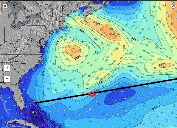
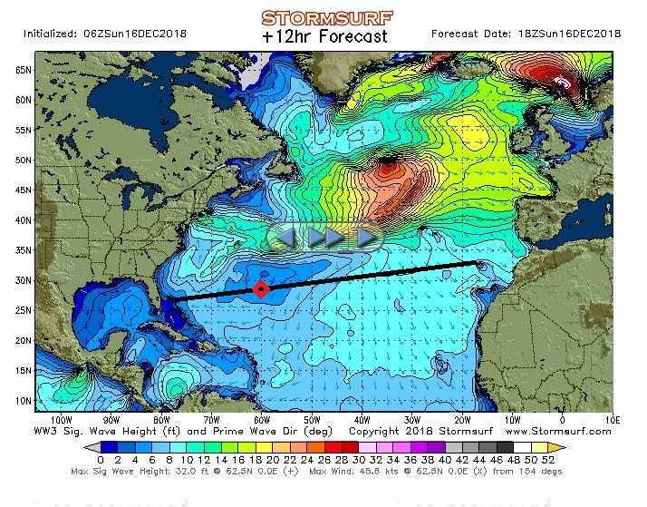
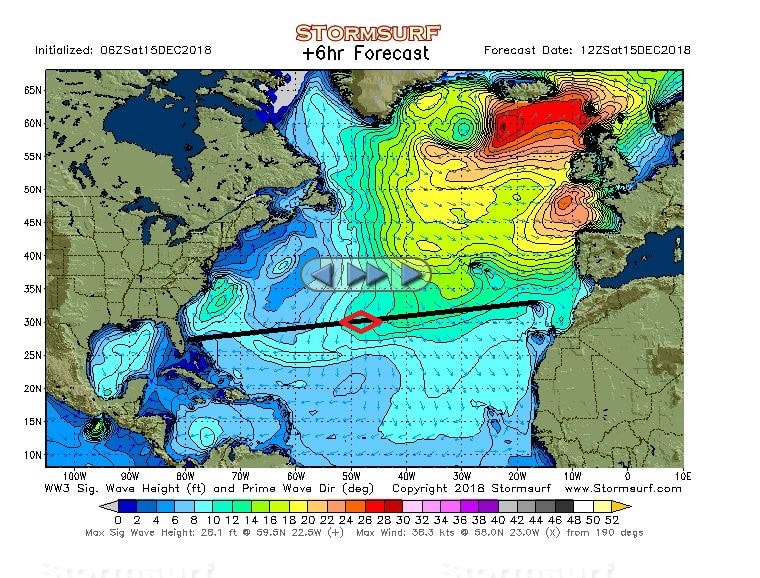
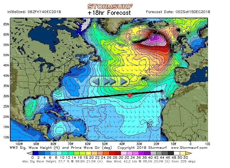
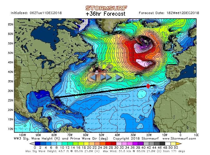
As you can see from the surf chart below, the very nasty storm to the north has developed some sort of tail and the 14 feet swell height boundary is now just touching the area we sail in and that gives a bit more movement. And nothing we can do about it as this sort of tail is hard to predict and thus the Captain cannot just start sailing south on the off chance that it might happen. But we still have wonderful weather so why should he?

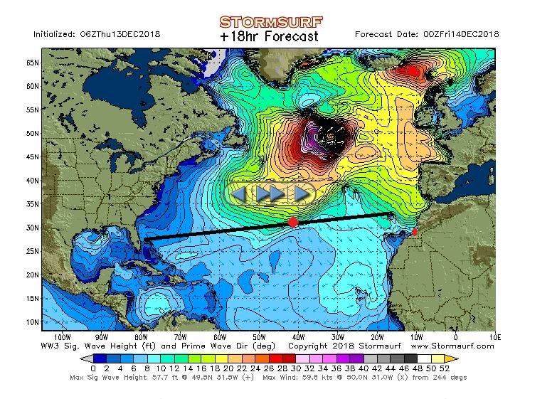
The North Atlantic Wave fields as expected around midnight. We are just on the edge and as it is a large area the boundary is not clearly set. Further up north is not a place to be with a ship. In the good old days when these weather charts where not out there, the Trans Atlantic Liners just ploughed through with scant regard for the “happiness” of those on board. (Diagram courtesy www.stormsurf.com)

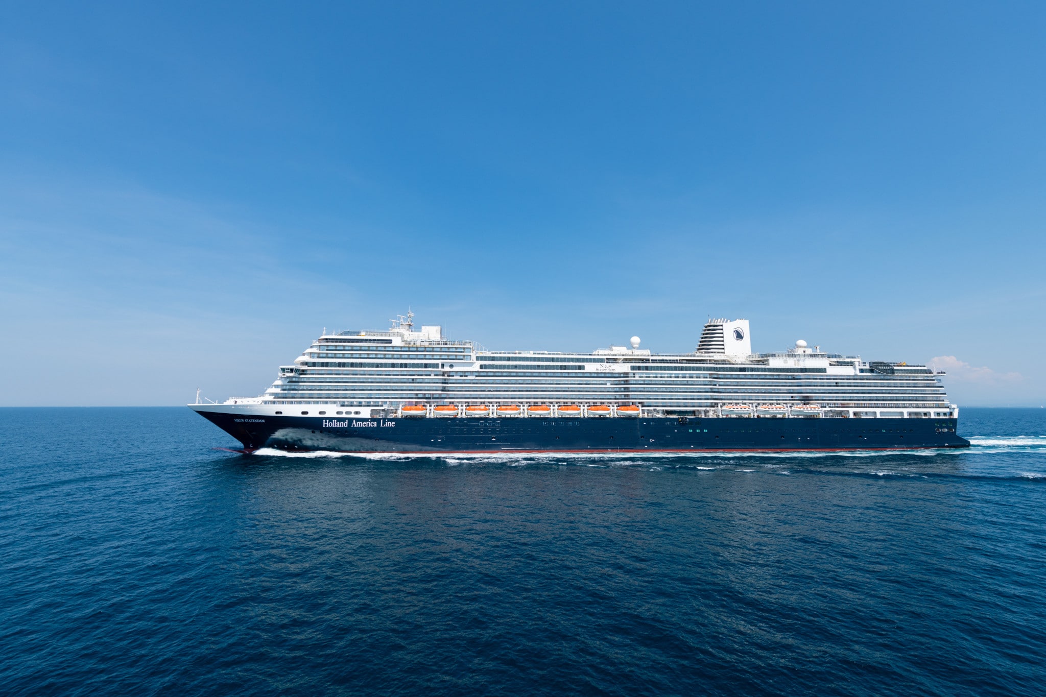
Yesterday’s story about weight and buoyancy brings us to the next item: How big is the ship? Also about this topic there is a lot of confusion, especially when it comes to the word tonnage. Passenger ships are rated in tonnage and a lot of people think that the number given is the weight of the ship. It is not.

Our Nieuw Statendam:

99,836 Gross Register Tons, 68,042 Nett Register Tons, Dead weight: 7840 tons, Displacement 64,802 tons at summer draught.

All these tonnages can cause confusion but a ship is measured in different ways to figure out various volumes and real weights as that has consequences for taxes or licenses or other regulatory requirements. Calculating these various tonnages is highly complicated so I will describe it a general way and might skirt the corners of the exact rulings a little bit to make it understandable.

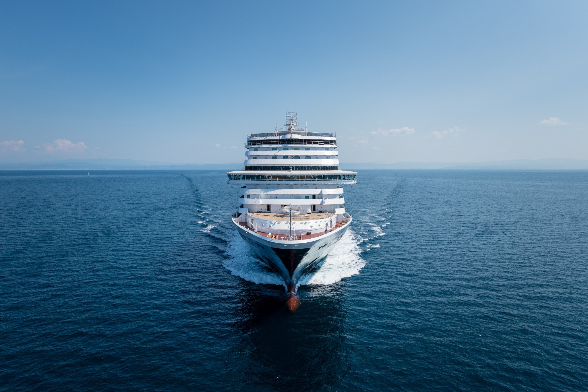
When we talk about the size of a cruise ship, we mean the GRT, for the Nieuw Statendam that is 99,836 tons, so just under the 100,000. A measurement that is important for Venice as they have a cap on cruise ships over the 100,000. Thus Venice uses this measurement for their regulatory requirement. Gross Tonnage refers to all the enclosed spaces on board. This gives the strange situation that when we open the Magrodome, then this tonnage would change as the whole Lido Deck is now open to the outside. But the rules have foreseen this and ships with Magrodome are calculated with the Dome closed.

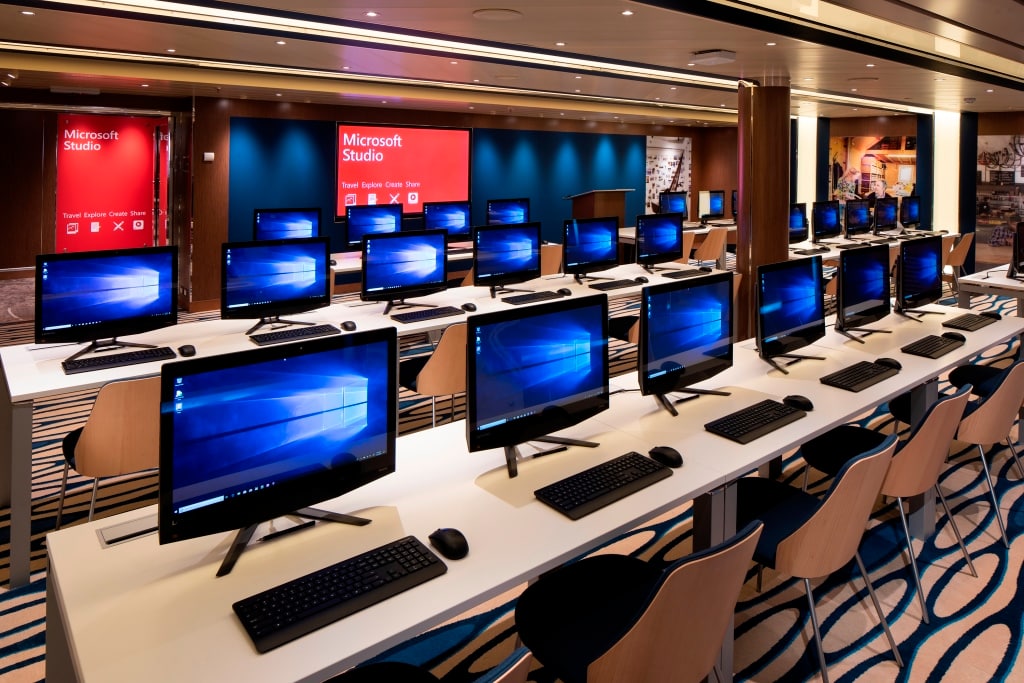
This is the Microsoft Workshop. In use for our cargo so part of the NRT. (Photo Courtesy Holland America Line)

Then the NRT or Netto tonnage. This is a calculation of all the cargo spaces on board. A cruise ship is not a cargo ship but our public areas generate revenue as “our cargo” enjoys themselves there. So roughly 2/3 of our ships volume is given over to our guests and anything in relation to that. The figure is derived at by subtracting all non cargo spaces (such as engine spaces, kitchens etc.) from the GRT.

Then we have DWT or Dead weight: this is what we carry as weight with us, such as oil, water, stores and supplies and also the weight of our guests and crew. As every person on board can have a different weight, an average of 75 kg. is used.

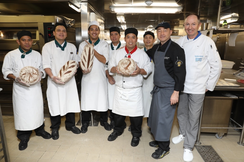
This the Bakery with the bakery team and two corporate trainers. Although the  guests enjoy the results of their labors, the bakery is not a cargo space and is thus part of the volume derived at when you subtract the NRT from the GRT. (Photo courtesy Holland America Line)

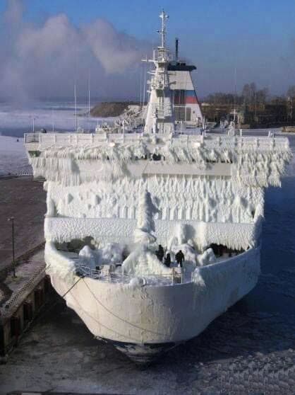
And then there is the displacement and that is the actual weight of the ship. This is always given in relation to a draught or draft. Why, because the ships weight pushes water away and seawater weighs more per ton than fresh water and brackish water is different again. Design draughts for a ship also vary as the ship sinks in less in seawater (seawater has more buoyancy) than fresh water and safety requirements might describe a different maximum draft in the summer as in the winter. (As we saw yesterday if ice would settle on a ship it would increase the weight and thus the draft)

I think this rather strange bulge in the tail of this nasty storm is caused by its intensity as it has black and white colors on the diagram. The wave heights are around 50 feet or more, caused by 60 knots of wind and all that energy has to go somewhere. Because of it, the weather is expected to change a little bit. The wind direction will follow this edge of the storm and will turn to the north and we might get the rainy tail of it all and thus some rain could fall. Not good for our guests who have been sitting in the sunshine in the past few days, but it will make the Bo ‘sun happy as it is an ideal help with getting the salt off the decks. We might have to keep the Magrodome closed tomorrow and increase our tonnage.

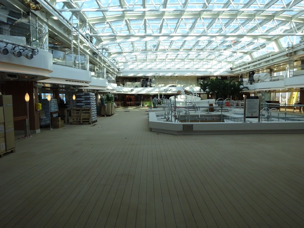
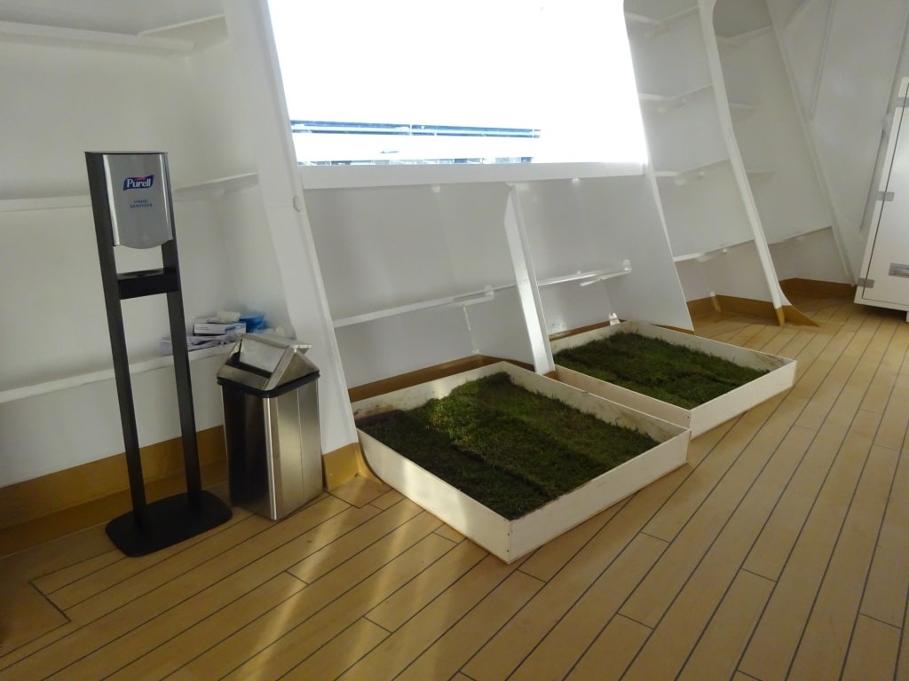
The ships Magrodome. The Close or Open option could greatly affect the measurements if the rules had not foreseen it. This photo was taken during the building period when they just had started loading the pots and plants. All that garden soil in those bags, does affect the displacement of the ship.

12 December 2018; Crossing the North Atlantic, day 2.

Another nice day to savor. Today we observed a long running swell, which was a little higher than predicted and came in under the angle of about 45o on the sb. bow. If that happens then you get a little bit of pitching (bow up and down movement) and a little bit of rolling (sideways movement). For the rolling we have stabilizers but for the pitching nothing has been invented yet. The angle of the swell never remains exactly the same, so we had varying degrees of one or the other. But it was all minimal and I had to stand still and concentrate to feel it. (And in the meantime being overtaken in full speed by guests hurrying to breakfast). The forecast for the next 24 hrs. is also good again although it seems, based on the two day experience since leaving Funchal) that the swell is a little bit higher than then Storm wave forecast gives. But if you look at the wave chart there is not much to worry about.

North Atlantic waves today. Being an Irish fisherman would not be my favorite job today.

Today I was asked and not for the first time, the Nieuw Statendam has 8 meters under water and more than 35 meters above water, why do we not fall over? Easy to ask, not so easy to answer because when you look at the ship, she is indeed very high.

This is a shot from the Ships trial trips in August. As you can see perfect weather to test a ship out. (Photo courtesy Holland America / Fincantieri)

Going back to the old days, the old sailing ships with their high masts and all the wind force on the sails they did not fall over either. They had weight, either cargo or ballast deep in the hull that kept the ship upright. So in principle a cruise ship should not fall over either. Secondly there is the hull. It is watertight and it creates buoyancy and that keeps a ship floating. As long as there is more buoyancy, which pushes the ship up, than there is gravity which pushes the ship down, the ship will stay afloat. There is of course a moment when the two forces cancel each other out and it only needs a little push for gravity to win and there the ship goes.  It sinks.

You can try this with a tin can in the bath tub. No water inside and the can will bob on the water and it floats. Start pouring water inside, this is called ballasting, and the tin can will settle. The right amount of water and there will be a perfect balance between sitting in the water (not bobbing up and down anymore) and not falling over either. That is what the stability officer does on board, figuring out the most perfect balance.

This is the tank layout of the S class ships. Blue is what is normally under water and purple is the part of the ship that is watertight to keep water from coming in. With our ships that is where the blue hull goes to white. In the double bottom we have Potable water, ballast water and fuel to keep the ship nice and steady in the sea.

If you keep filling the tin can with water then eventually the tin can will sink. Gravity has won from buoyancy. It is not only gravity that has influence, wind can do it as well, pushing against the superstructure and helping the gravity.  Now cruise company’s (read the guests) want more and more balconies and they are not good for wind. With a flat wall it can already be bad but some of the wind is deflected up or down. With balconies the wind “bites” into those little boxes and is not deflected anymore. Very nasty.

Apart from wind, ice is also not good for stability. It adds weight and if the design of the ship = stability does not takes this into account then things can go horribly wrong.

Thus we need a solution if a ship still needs to have more decks to have more balconies. You can add weight, in the low part of the ship, but then the draft increases. Nowadays we want to keep the ships draft around 8 to 8.5 meters otherwise there will be a lot of cruise ports (such as in the Caribbean) which will become a real problem. The other solution is to go sideways; make the ship wider. Then the weight gets distributed over a larger area, that improves buoyancy and the ship does not have to sink in that far. We increase the buoyancy. And that is what is done nowadays. (Try it again in the bath tub by comparing an oblong tin can, versus a round tin can of the same volume. You will need less water to make the oblong tin can stable.

As a result the Pinnacle Class is wider than the Vista Class because the Koningsdam and the Nieuw Statendam are higher. As a result the Vista Class fits in the old Panama Locks and the Pinnacle Class does not. A lot of the new cruise ships do not fit in those locks anymore. In Amsterdam they are building a new lock, the biggest one in the world, to ensure that larger cruise ships can still visit the City.


Another shot of the Nieuw Statendam on her trials last August. (Photo Courtesy: Holland America / Fincantieri)

How wide you go with the ship is basically a company decision. The wider you go, the more spare stability you have and the more steady the ship is. But you still have to go into port and harbor entrances are not always that wide either, and it also increases the resistance through the water and that costs more fuel. So a compromise is always needed. The hull form of the Pinnacle Class ships is very steady and a delight for any stability officer as there is very little need to play around with ballast to keep an optimum situation. The Nieuw Statendam is basically stable at all times.

Until so far my lecture for today……………………………………..

Tomorrow is another day at sea, with very little change. Things are looking very good.

11 December 2018; Crossing the North Atlantic, day 1.

We made a good start of the crossing, there is hardly any wind and only a very low swell running of about 6 -8 feet in height, and that swell got slightly less during the day as well. We have partly cloudy skies with a mix of Cumulus and stratus clouds. They indicate that far away things are not exactly happy, but here all is well in the world. Madeira is at a latitude that is slightly higher than Fort Lauderdale and thus we are sailing on a course of 262o which is just 8 degrees less than due west.  As we have 8 sea days to play with the ship is sailing along at a sedate speed of 16 knots and that gives everybody a comfortable ride.  Cruising is often about seeing the world but lots of cruise guests also enjoy the sea days when the ship becomes a destination in itself. The Nieuw Statendam has a lot to offer so I do not think that people will be bored while on board. One of our old captains used to say: “Doing Nothing is also doing Something” and I saw a lot of our guests doing exactly that.

Nasty things on the North Atlantic. This Is the prediction for the next 24 hrs. plus. As long as we stay out of the light green, we will have a smooth crossing. (Courtesy: www.Stormsurf.com)

I am doing my best to help out so I gave a little lecture about the High Days of Trans-Atlantic Travel which in my opinion was between 1900 and 1960 when the airplane became dominant on the North Atlantic. (In 1958 as many people traveled by plane as by ship and by 1959 the plane had won the battle). Part of that Heyday was the push by governments to have their national predominant ships on the North Atlantic. The fastest, the most luxurious, often statements of what economic capability a country had. The way the ships were built, the lavishness of the interiors full with national art and the way they were run, was all about National Pride. Great Britain, France, Italy and Germany were the countries battling it out. The Blue Riband, denoting the fastest ship on the North Atlantic went from ship to ship and thus from country to country. Some company’s were proud to fly it (French Line) and some company’s (Cunard) officially ignored its existence but kept building fast ships nevertheless.

This is one of our big ships, the ss Rotterdam (IV) from 1908. This painting is now in the archives of the Rotterdam Maritime Museum. (Photo courtesy Schaart Photographers)

Holland America was never much involved with this. The Netherlands was a small country in Europe and it’s size as an Empire came from the Far East and the Caribbean, not from its location in Europe. Still we built big and luxurious ships but the ships had to pay for themselves as the Dutch Government was not throwing money away just for the fun of showing off. So while the Blue Riband might bring a lot of attention, it often needed a lot of money from the national government to keep these ships going as they burnt excessive amounts of coal and later fuel.

The exponential increase in power needed to make a ship go faster and faster.

Ships speed versus power needed is not a straight increase, but is a curve that gets steeper and steeper the fast you want to go. Our Nieuw Statendam does 16 knots on 2 engines, but would need all 4 engines to reach the 22.5 – 23 knots she is rated for, so two more engines of the same size to gain 6 more knots in speed. Hence the Old Ocean Liners needed 160,000 horsepower to get to the Blue Riband speed of 30 to 35 knots.


The final Blue Riband holder, the ss United States, was rumored to be able to go over 40 knots and her boilers could produce 240,000 Hp.  That gave a fuel bill of over an 1000 tons a day. That ship was 54000 tons in volume while your Nieuw Statendam is 99,000 tons and runs on a daily consumption in the region of 80 to 90 tons depending on the number of engines going.

The ss United States. The last true holder of the North Atlantic Speed record. She is still out there. Docked in Pennsylvania and maybe she will be used for something again in the future.

The only way to reduce the need for that power is to reduce the resistance in the water and hence the invention of  hydrofoils, catamarans and related ships. So since the United States, three of those boats have gone faster over the North Atlantic and claimed the blue Riband. But I do not agree with that as the quest for North Atlantic speed was in conjunction with carrying paying passengers and mail across the pond and not just for going for the record with a modified speed boat which would never commercially operate on that service.

This is currently the fastest commercial craft that sailed the North Atlantic. But is is not an ocean liner and she never was employed there as such.

But it is all relative. The ss United States could have done Funchal to Fort Lauderdale in just over 3 days, while we are going to take 8. But then we are not in a hurry as this is a cruise and not a Bus service to get to the next business meeting on time. As long we get their by the 19th. it is all fine by me, as I have a flight home that day.

Weather: looks good, smooth seas and little winds.

10 December 2018; Funchal, Madeira / Portugal.

Last night we went an hour back so we are now on English time but also on Portuguese time. Although Madeira is really just in another time zone, it is kept in the same time zone as the mother country. Hence the sun did not rise very early this morning when the ship arrived. But sailing into Funchal in the dark is very nice as well, as the houses of the town are clustered around the port and go all the way up the mountain. At night they might switch most of the lights off, but Madeirans also have breakfast and then the lights in the houses come on again. Plus we had the whole day to admire Funchal in daylight anyway.

A Google earth view of the port from a day with two cruise ships inside. One looks like a Princess ship (shopping trolley Class) and the other one a Celebrity ship. We were docked all the way in with our nose almost at the bus stop. (Blue square) The Ex Westerdam was across at the berth where it says CR7.

Funchal is a nice port and a sheltered port from most of the North Atlantic weather as the large mountain range shields it from what blows out there. Only when the storm comes too much to the South or South-South –West then the bad weather reaches into the port and ships cannot get in. In my whole career I think I had to cancel only once as there was too much swell running into the port, to stay safely alongside. Even when docked all the way in, there where we are now.  Funchal throws a very good New Year’s Eve Fireworks party and sometimes 7 or 8 cruise ships (mainly from England) then gather here for the event. And then it is keeping fingers crossed that there is no storm ranging which prohibits the fireworks to go off and/or the ships to remain drifting in position.

While I was figuring out how to stop a fire in the Main Galley by pushing shut down buttons in the right sequence. I saw something white coming by and was then delighted to see the Marella Dream in port. Why because she is my old ship the Westerdam (II) which we had in service from 1988 to 2004. Built as the Homeric for Home Lines, she came to Holland America in 1988 when HAL bought Home Lines out. That company had two ships, the Homeric and Atlantic. The Homeric was a beautiful ship so we kept it, the Atlantic was of less interest as it was not built that well and hence the company chartered it out and later sold it. The last thing I heard about her was that she lay half sunk in an Indian port.

I was 2nd Sr. Officer on the Westerdam (II) when we returned to her builder in Papenburg Germany for the stretch. You can easily see the added section as the windows — in the middle — are larger.

When we bought the Homeric we also found out that the ship has been intended to be bigger but as she had to fit in Front Street Hamilton, Bermuda, that did not happen. So Holland America grabbed the change to have her stretched as we were battling Carnival at that time and needed to be as cost effective as we could, and larger ships give economies of scale. While the Homeric with 42000 tons was already the biggest ship Holland America ever had; after the 100 feet stretch she went up to 52000 tons and remained the biggest ship in the fleet until the arrival of the S class. She was very well built and by use very well maintained, hence she is still out there. Holland America handed her over to Costa where she became the Costa Europa and then she ended up with Tui / Thomson as a package holiday ship for the English market, called the Thomson Dream. Here she was re-united with her former fleet mates the Noordam (III) and the Nieuw Amsterdam (III) who had also gone into Thomson charter. Last year I suddenly saw her in Greece as the Celestial Elysius but now she is back under the name Marella Dream as the Thomson Company rebranded itself under the Marella name.

A His & Hers ??? on Deck 3 aft ? Even doggies get the 5 star treatment with HAL.

While out on the deck, I also noticed the grass boxes for our Guide and Service dogs. I believe we have five on board for this crossing, including Tosca, the Dutch Blind Guide dog, who is well on her way to go over 400 days.  Normally the carpenter makes one big box, now we have two, so I am wondering if this is a HIS and HER box.  Would not be amazed as our crew does have a good sense of humor.

We sailed right on the dot of 17.00 hrs. and started our 8 day crossing to Fort Lauderdale. Of most interest is of course the “wobbly-ness” of the ocean. For the first 48 hrs.it looks as if we have good smooth seas with swell less than 10 feet. But the computer model forecasts another storm being generated at Cape Hatteras. That storm will not reach us but with the forecast track, we might just skirt the 14 feet swell boundary and that we could feel. But it will all depend on the angle of the waves to how the stabilizers can deal with it.

09 December 2018; At Sea.

Yesterday in Malaga all the movers and shakers of our company left the ship, to return to Seattle and their daily chores, and the crew continued with their focus on making this a memorable maiden voyage or premiere cruise as marketing calls it. On board are 2019 guests and 1026 crew and that is about 40 crew over the regular Table of Personnel as there is still extra support on board to fine tune things and carry out last minute enhancements.  I think some of them are leaving tomorrow and the rest in Ft. Lauderdale which will include Yours Truly as nobody likes me around during Christmas as I cause drills to happen instead of Christmas songs.

Various ferry crossing while going through the Straits.

The bridge reported that things were very quiet in the Straits of Gibraltar last night with just the regular ferry traffic crossing the Straits. Ferries are normally easy to deal with. You know where they are going, you know they do not like to change course as that costs time, so if you yourself change course timely, even if it is not really you who has to, then you seldom have a problem. They are happy that they can keep their time table and yourself have made your own life a lot easier just by being a little bit proactive.


To keep those in check who have not learned this lesson yet, there are Vessel Traffic Separation Zones, our highways at seas which separate east and west bound traffic, and there is Tarifa traffic. This is a calling in and monitoring station which keeps an eye on all the traffic in the Straits and is located in the Spanish port of Tarifa. For the linguists among us, Tarifa gave us the word tariff, as it was a major tax collecting point in the entrance to the Mediterranean in the good old days.

The ships highways at sea. Inbound stays on the African side, outbound on the European side.

To “change course even when you do not have to” is also sort of the company’s safety philosophy and I hope also of the rest of the cruise industry. We carry humans on board and it is then all about minimizing risk. We do that with the ships itself and we also train our tender drivers this mantra and that is one of the reasons you see our tenders sometimes waiting for traffic while they really do not have to do that, as they have the right of way. But better safe than sorry. When our tender drivers are out there with their valuable loads of guests, the mantra goes:

Stop or turn away for: canoes, sailing boats, larger ships, tugboats, basically for anything of which you are not certain what they are going to do or who are much less maneuverable then you are. When you meet one of the tenders of your own ship, follow the Rules of the Road as you know that your colleague will do the same.

As you can see very nasty weather on the North Atlantic but we had to sail through a bit of that green stuff as we are on a south westerly course. The small wave field dissolved  late morning

Although I had predicted smooth seas, it did not turn out completely that way. They have a whopper of a storm in Western Europe at the moment: Schiphol / Amsterdam airport was closed for a while and the swell of that storm came a bit further south than the simulation of yesterday predicted. So instead of having 10 feet swell, what we normally do not notice, it just touched the 14 feet and that made the Nieuw Statendam move just a little. Not much but just enough to feel that she is a ship and not an apartment building. I do not think that it affected many guests, as at 07.00 hrs. this morning, when I went for breakfast the Lido was already in full swing.


When you make a North Atlantic crossing the captain can basically select out of three options: The straight line over the Globe, which is in reality a curved line as the World is round. This is called a Great Circle route and is the shortest as it follows the contours of the earth. Then you can follow the straight line in the chart, this is called a Rhumb line but it is a longer route. It is a number of miles longer as a flat chart can never give the same surface as a globe, due to the way the globe’s features are projected on this piece of paper. Because of the earth curvature it goes further south and it keeps you away further away from the bad weather of the North North Atlantic. Then the 3rd option is to follow the “flat water” route, the route advised by meteorologists. That route will take you much further to the South, sometimes very far to the south and is much longer. So the Captain has to decide what is best for the crossing. Smooth Seas where possible, low fuel consumption where possible, arrival on time for certain. But that is something for after Funchal.

We are now on a Rhumb line = straight line to Madeira and Funchal. Trying to do a Great Circle here would not bring any gains, as the distance it too short. So we head straight for Madeira. This island belongs with four other islands to Portugal but is located far to the south of the mother land; hence we can make this crossing with nice weather.

Weather for Funchal 67oF / 19oC, mainly Sunny and no wind, nor rain expected. Tomorrow we will look at the rest of the crossing.

Older posts